

<< Our Photo Pages >> Vigstein - Standing Stone (Menhir) in Norway in Akershus
Submitted by kenntha88 on Thursday, 02 October 2014 Page Views: 1740
Neolithic and Bronze AgeSite Name: VigsteinCountry: Norway Fylke: Akershus Type: Standing Stone (Menhir)
Nearest Village: Nannestad
Latitude: 60.211600N Longitude: 11.075828E
Condition:
| 5 | Perfect |
| 4 | Almost Perfect |
| 3 | Reasonable but with some damage |
| 2 | Ruined but still recognisable as an ancient site |
| 1 | Pretty much destroyed, possibly visible as crop marks |
| 0 | No data. |
| -1 | Completely destroyed |
| 5 | Superb |
| 4 | Good |
| 3 | Ordinary |
| 2 | Not Good |
| 1 | Awful |
| 0 | No data. |
| 5 | Can be driven to, probably with disabled access |
| 4 | Short walk on a footpath |
| 3 | Requiring a bit more of a walk |
| 2 | A long walk |
| 1 | In the middle of nowhere, a nightmare to find |
| 0 | No data. |
| 5 | co-ordinates taken by GPS or official recorded co-ordinates |
| 4 | co-ordinates scaled from a detailed map |
| 3 | co-ordinates scaled from a bad map |
| 2 | co-ordinates of the nearest village |
| 1 | co-ordinates of the nearest town |
| 0 | no data |
Internal Links:
External Links:
")
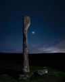
Just next to a small residential neighbourhood close to the Gardermoen airport is a pretty standing stone. It is located in a wheat field but only around 10 metres from the road. I could not get close to the stone but photographed it from a distance.
There are some local legends connected to the stone:
A legend says that one night a long time ago, a freed slave came to the farm and asked for shelter. The farmer refused him, and chased him out the door. The servant went away, but when he came back to the farm, he turned around and called a curse upon the farmer and the farm. They would see that he could not be chased away so easily, and that it would go that bad with those trying to remove him. And the day after, the slave turned into stone and is still standing there as the standing stone.
And there it stood until sometime in the 1800s, when a landowner on Vigstein farm were in need of some foundation stones for his barn and he used Vigsteinen stone. There are several versions of what happened next. A tradition says that one or more houses burned, another that one or more of the cows died in the barn. Anyway, Vigsteinen was taken out of the foundation and put in place in the field where it has stood since.
The stone is around 1,90m in height, around 65cm wide at the base and around 22cm thick. It has a rectangular cross section with a straight cut top.
You may be viewing yesterday's version of this page. To see the most up to date information please register for a free account.
")
")
")
")
")
")
")
")
")
")
")
")
")
")
Do not use the above information on other web sites or publications without permission of the contributor.
Click here to see more info for this site
Nearby sites
Click here to view sites on an interactive map of the areaKey: Red: member's photo, Blue: 3rd party photo, Yellow: other image, Green: no photo - please go there and take one, Grey: site destroyed
Download sites to:
KML (Google Earth)
GPX (GPS waypoints)
CSV (Garmin/Navman)
CSV (Excel)
To unlock full downloads you need to sign up as a Contributory Member. Otherwise downloads are limited to 50 sites.
Turn off the page maps and other distractions
Nearby sites listing. In the following links * = Image available
180m ENE 63° Kneppefeltet-Vigsteinmoen* Barrow Cemetery
1.1km SSW 193° Kjosholtet* Barrow Cemetery
4.1km WSW 246° Lysthaugen* Long Barrow
7.2km SSE 165° Villashaugen* Round Barrow(s)
7.7km SSE 159° Hertelshaugen* Round Barrow(s)
8.0km SSE 155° Rakni's Mound* Round Barrow(s)
8.0km SSE 163° The Prince's Mound* Round Barrow(s)
8.7km NW 320° Vålaug* Round Barrow(s)
9.6km NW 323° Bårhaugkampen Hillfort* Hillfort
10.4km NNE 26° Tollhaugen* Round Barrow(s)
11.7km SE 138° Bekkedalsgutua* Round Barrow(s)
12.0km SE 137° Skinnfellbråtan* Barrow Cemetery
12.2km S 177° Torshov* Barrow Cemetery
12.6km SE 138° Åssand* Round Barrow(s)
12.8km SE 132° Fonbekkhagan* Barrow Cemetery
17.0km S 172° Brotnuhaugen-Snilehaugen* Round Barrow(s)
22.9km ESE 106° Hennihaugen* Round Barrow(s)
24.0km S 184° Sten-Tærud* Barrow Cemetery
24.2km S 184° Skedsmo Kirke Phallitic Stone* Standing Stone (Menhir)
24.5km WNW 291° Haakenstadlinna-Kongshaug* Round Barrow(s)
24.6km SSE 158° Valsmoen* Barrow Cemetery
25.4km S 176° Asak Cemetery* Barrow Cemetery
26.4km SSE 158° Bingsfossen Helleristninger* Rock Art
27.0km SSE 150° Lille Huseby og Kjempehaugen* Round Barrow(s)
27.2km SSE 150° Hellerudåsen cemetery* Barrow Cemetery
View more nearby sites and additional images


 We would like to know more about this location. Please feel free to add a brief description and any relevant information in your own language.
 Wir möchten mehr über diese Stätte erfahren. Bitte zögern Sie nicht, eine kurze Beschreibung und relevante Informationen in Deutsch hinzuzufügen.
 Nous aimerions en savoir encore un peu sur les lieux. S'il vous plaît n'hesitez pas à ajouter une courte description et tous les renseignements pertinents dans votre propre langue.
 Quisieramos informarnos un poco más de las lugares. No dude en añadir una breve descripción y otros datos relevantes en su propio idioma.