

<< Our Photo Pages >> Otahuhu Pa - Hillfort in New Zealand
Submitted by DrewParsons on Monday, 05 August 2013 Page Views: 4790
Iron Age and Later PrehistorySite Name: Otahuhu Pa Alternative Name: Mt Richmond Pa, R11/13Country: New Zealand Type: Hillfort
Nearest Town: Auckland Nearest Village: Otahuhu
Latitude: 36.93224S Longitude: 174.839740E
Condition:
| 5 | Perfect |
| 4 | Almost Perfect |
| 3 | Reasonable but with some damage |
| 2 | Ruined but still recognisable as an ancient site |
| 1 | Pretty much destroyed, possibly visible as crop marks |
| 0 | No data. |
| -1 | Completely destroyed |
| 5 | Superb |
| 4 | Good |
| 3 | Ordinary |
| 2 | Not Good |
| 1 | Awful |
| 0 | No data. |
| 5 | Can be driven to, probably with disabled access |
| 4 | Short walk on a footpath |
| 3 | Requiring a bit more of a walk |
| 2 | A long walk |
| 1 | In the middle of nowhere, a nightmare to find |
| 0 | No data. |
| 5 | co-ordinates taken by GPS or official recorded co-ordinates |
| 4 | co-ordinates scaled from a detailed map |
| 3 | co-ordinates scaled from a bad map |
| 2 | co-ordinates of the nearest village |
| 1 | co-ordinates of the nearest town |
| 0 | no data |
Internal Links:
External Links:
I have visited· I would like to visit
DrewParsons has visited here
")
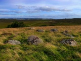
Otahuhu Pa was a Maori defended settlement located amongst the several cones and craters of Mt Richmond in the Auckland suburb of Otahuhu. The site is named after the tribal leader O-Tahuhu who was the son of chief Manaia who arrived in the Moekaraka Waka or ocean going migration canoe which landed near present day Goat Island. The pa controlled an important north to south trading route and was close to three portage sites. It also had good fertile volcanic soil for agriculture. There has been extensive quarrying at Mt Richmond but it is still possible to see the terraces, defensive banks and some kumara pits on the various volcanic cones in this park. There is a good surfaced walkway through the lower parts of the park where cattle roam freely.
References: S Bulmer, Sources for the Archaeology of the Maaori Settlement of the Taamaki Volcanic District, Dept of Conservation, Wellington, 1994
Auckland City Planning Papers: Mt Richmond Domain
You may be viewing yesterday's version of this page. To see the most up to date information please register for a free account.
")
")
")
")
")
Do not use the above information on other web sites or publications without permission of the contributor.
Click here to see more info for this site
Nearby sites
Click here to view sites on an interactive map of the areaKey: Red: member's photo, Blue: 3rd party photo, Yellow: other image, Green: no photo - please go there and take one, Grey: site destroyed
Download sites to:
KML (Google Earth)
GPX (GPS waypoints)
CSV (Garmin/Navman)
CSV (Excel)
To unlock full downloads you need to sign up as a Contributory Member. Otherwise downloads are limited to 50 sites.
Turn off the page maps and other distractions
Nearby sites listing. In the following links * = Image available
4.5km N 0° Maungarei Stonefields* Ancient Village or Settlement
4.5km N 8° Maungarei Pa* Hillfort
5.4km WSW 249° Mangere Mountain Pa* Hillfort
5.9km NW 311° Cornwall Park Rongo Stone* Standing Stone (Menhir)
6.2km NW 306° Maungakiekie Pa* Hillfort
7.5km NW 316° Te Kopuke Pa* Hillfort
7.6km NW 322° Remuera Pa* Hillfort
7.8km NNE 32° Tahuna Torea* Ancient Village or Settlement
8.0km NNE 20° Taurere Pa* Hillfort
8.3km NW 309° Epsom Modern Megalith* Modern Stone Circle etc
9.0km NW 312° Maungawhau* Hillfort
9.4km WNW 283° Puketapapa Pa* Hillfort
9.7km NW 325° Auckland Museum* Museum
12.5km NNE 23° Motukorea Cone Pa* Hillfort
19.4km NE 45° Matarahui Bay Pa* Hillfort
20.2km NNW 342° Rahopara Pa* Hillfort
21.3km NE 37° Mokemoke Pa* Hillfort
25.5km NW 314° Te Taou Pa* Hillfort
30.9km NNW 342° Okura 784 Settlement & Midden* Artificial Mound
31.6km NNW 342° Dacre Point Pa* Hillfort
32.9km NNW 344° Rarowhara Pa* Hillfort
33.5km NNW 349° Little Manly East Point Pa* Hillfort
34.0km N 353° Rakauananga Pa* Hillfort
34.7km ENE 68° Men's Bay North Pa* Hillfort
34.8km NNW 347° West Manly Pa* Hillfort
View more nearby sites and additional images


 We would like to know more about this location. Please feel free to add a brief description and any relevant information in your own language.
 Wir möchten mehr über diese Stätte erfahren. Bitte zögern Sie nicht, eine kurze Beschreibung und relevante Informationen in Deutsch hinzuzufügen.
 Nous aimerions en savoir encore un peu sur les lieux. S'il vous plaît n'hesitez pas à ajouter une courte description et tous les renseignements pertinents dans votre propre langue.
 Quisieramos informarnos un poco más de las lugares. No dude en añadir una breve descripción y otros datos relevantes en su propio idioma.