<< Our Photo Pages >> Remuera Pa - Hillfort in New Zealand
Submitted by DrewParsons on Tuesday, 21 August 2012 Page Views: 2706
Iron Age and Later PrehistorySite Name: Remuera Pa Alternative Name: R11/16Country: New Zealand Type: Hillfort
Nearest Town: Auckland Nearest Village: Remuera
Latitude: 36.87795S Longitude: 174.787380E
Condition:
| 5 | Perfect |
| 4 | Almost Perfect |
| 3 | Reasonable but with some damage |
| 2 | Ruined but still recognisable as an ancient site |
| 1 | Pretty much destroyed, possibly visible as crop marks |
| 0 | No data. |
| -1 | Completely destroyed |
| 5 | Superb |
| 4 | Good |
| 3 | Ordinary |
| 2 | Not Good |
| 1 | Awful |
| 0 | No data. |
| 5 | Can be driven to, probably with disabled access |
| 4 | Short walk on a footpath |
| 3 | Requiring a bit more of a walk |
| 2 | A long walk |
| 1 | In the middle of nowhere, a nightmare to find |
| 0 | No data. |
| 5 | co-ordinates taken by GPS or official recorded co-ordinates |
| 4 | co-ordinates scaled from a detailed map |
| 3 | co-ordinates scaled from a bad map |
| 2 | co-ordinates of the nearest village |
| 1 | co-ordinates of the nearest town |
| 0 | no data |
Internal Links:
External Links:
I have visited· I would like to visit
DrewParsons has visited here

Although Maori sites like Remuera Pa and settlement are much more recent compared to European hillforts (Maori settlement of New Zealand is dated to around 1250 AD) the people who inhabited them lived in a neolithic environment and faced similar challenges to those earlier European cultures. So there was the same recourse to defense involving palisaded ditches and embankments located on hilltops with settlements clustered around the site. These more modern New Zealand sites can give an insight into how older European sites might have been established.
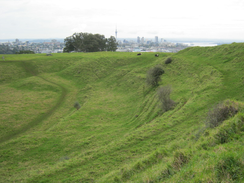
Remuera Pa, whose original name was Ohinerangi (The dwelling place of Rangi), still has well preserved ditches and embankments and hilltop earthworks which would have served as a redoubt. No archaeological excavations have been undertaken at the site which now forms part of a public park with cattle sometimes grazing in it. The pa is located on Mt Hobson, an extinct volcanic cone located in the suburb of Remuera. It was an ideal place for early Maori migrants to settle given that it had obvious defensive qualities coupled with its proximity to forest and sea food sources and rich volcanic soil for growing kumera and similar crops brought by the Maori from their ancestral Hawaiki homeland in distant Polynesia.
A similar story of rivalry and conquests by hostile tribes feature in the Auckland region with the Waiohua occupants of this pa killing and eating a young visiting Hauraki tribal chieftainess (the name Remu-era means burnt edge of a garment referring to the charred remains of the hapless girl). By 1741 the Waiohua chief Kiwi Tamaki was killed in a battle by members of the Ngati Paoa and Ngati Whatua tribes and control of this and other local pa went to the invaders. They in their turn were routed by the now musket armed northern Nga Puhi tribe led by Honga Hika who devastated the tribes around the Whangaparaoa Peninsula on the way south to Auckland. These attacks largely cleared the Auckland Isthmus except for small pockets of Ngati Whatua and by the 1830s some returning Ngati Paoa. This situation continued until the 1840s saw the advent of European settlers.
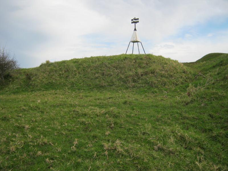
The site can be reached through any of three entrances to the park although car parking is easiest in Dilworth Avenue. From half way down this suburban road there is a steep grass track to the summit of the volcanic cone from where there are grand views across Auckland. Following left (north) around the flat area (below which a water reservoir now exists) you reach the first of the ditch and embankment defensive lines. Sometime cattle are grazing in this area but they are well used to visitors. Further up towards the trig point on the summit more evidence of ditches and embankments remain, whilst below there are the usual terraces of narrow flat land which were used for growing kumera and other crops and for housing.
References:
Mt Hobson / Remuera Management Plan, Auckland City Council
S Bulmer, Sources for the Archaeology of the Maaori Settlement of the Taamaki Volcanic District, Dept of Conservation, Wellington, 1994
You may be viewing yesterday's version of this page. To see the most up to date information please register for a free account.






Do not use the above information on other web sites or publications without permission of the contributor.
Click here to see more info for this site
Nearby sites
Click here to view sites on an interactive map of the areaKey: Red: member's photo, Blue: 3rd party photo, Yellow: other image, Green: no photo - please go there and take one, Grey: site destroyed
Download sites to:
KML (Google Earth)
GPX (GPS waypoints)
CSV (Garmin/Navman)
CSV (Excel)
To unlock full downloads you need to sign up as a Contributory Member. Otherwise downloads are limited to 50 sites.
Turn off the page maps and other distractions
Nearby sites listing. In the following links * = Image available
886m SW 223° Te Kopuke Pa* Hillfort
1.9km WSW 245° Epsom Modern Megalith* Modern Stone Circle etc
2.1km W 270° Maungawhau* Hillfort
2.1km NNW 336° Auckland Museum* Museum
2.2km S 174° Cornwall Park Rongo Stone* Standing Stone (Menhir)
2.5km S 188° Maungakiekie Pa* Hillfort
4.9km ESE 109° Maungarei Stonefields* Ancient Village or Settlement
5.5km ESE 106° Maungarei Pa* Hillfort
5.9km SW 229° Puketapapa Pa* Hillfort
7.5km ENE 79° Taurere Pa* Hillfort
7.6km SE 142° Otahuhu Pa* Hillfort
8.0km S 183° Mangere Mountain Pa* Hillfort
8.7km E 86° Tahuna Torea* Ancient Village or Settlement
11.1km ENE 60° Motukorea Cone Pa* Hillfort
13.3km N 353° Rahopara Pa* Hillfort
18.0km NW 311° Te Taou Pa* Hillfort
19.9km ENE 68° Matarahui Bay Pa* Hillfort
20.7km ENE 58° Mokemoke Pa* Hillfort
23.9km NNW 349° Okura 784 Settlement & Midden* Artificial Mound
24.5km NNW 348° Dacre Point Pa* Hillfort
26.0km N 351° Rarowhara Pa* Hillfort
26.9km N 356° Little Manly East Point Pa* Hillfort
27.7km N 1° Rakauananga Pa* Hillfort
28.0km N 354° West Manly Pa* Hillfort
29.6km N 6° Shakespear Homestead Pa* Hillfort
View more nearby sites and additional images




 We would like to know more about this location. Please feel free to add a brief description and any relevant information in your own language.
 Wir möchten mehr über diese Stätte erfahren. Bitte zögern Sie nicht, eine kurze Beschreibung und relevante Informationen in Deutsch hinzuzufügen.
 Nous aimerions en savoir encore un peu sur les lieux. S'il vous plaît n'hesitez pas à ajouter une courte description et tous les renseignements pertinents dans votre propre langue.
 Quisieramos informarnos un poco más de las lugares. No dude en añadir una breve descripción y otros datos relevantes en su propio idioma.