


<< Our Photo Pages >> Yar Tor SE - Multiple Stone Rows / Avenue in England in Devon
Submitted by TheCaptain on Friday, 28 November 2003 Page Views: 7369
Neolithic and Bronze AgeSite Name: Yar Tor SECountry: England County: Devon Type: Multiple Stone Rows / Avenue
Nearest Town: Princetown Nearest Village: Dartmeet
Map Ref: SX68187388 Landranger Map Number: 191
Latitude: 50.549779N Longitude: 3.86201W
Condition:
| 5 | Perfect |
| 4 | Almost Perfect |
| 3 | Reasonable but with some damage |
| 2 | Ruined but still recognisable as an ancient site |
| 1 | Pretty much destroyed, possibly visible as crop marks |
| 0 | No data. |
| -1 | Completely destroyed |
| 5 | Superb |
| 4 | Good |
| 3 | Ordinary |
| 2 | Not Good |
| 1 | Awful |
| 0 | No data. |
| 5 | Can be driven to, probably with disabled access |
| 4 | Short walk on a footpath |
| 3 | Requiring a bit more of a walk |
| 2 | A long walk |
| 1 | In the middle of nowhere, a nightmare to find |
| 0 | No data. |
| 5 | co-ordinates taken by GPS or official recorded co-ordinates |
| 4 | co-ordinates scaled from a detailed map |
| 3 | co-ordinates scaled from a bad map |
| 2 | co-ordinates of the nearest village |
| 1 | co-ordinates of the nearest town |
| 0 | no data |
Internal Links:
External Links:
I have visited· I would like to visit
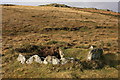
TheCaptain visited on 11th Apr 2019 - their rating: Cond: 2 Amb: 3 Access: 3 The Yar Tor triple stone row is much clearer to see than I remember it being decades ago, when I can barely remember finding much at all. Almost certainly what has become known as the Yar Tor SE rows is a section of the main triple row which has become separated from the main part of the rows. Looking all aound at the top end, by the moneypit cairn, I could find nothing of another set of rows, but I didn't spend too long looking and the gorse here was vicious!
Catrinm visited - their rating: Cond: 2 Amb: 3 Access: 4
Average ratings for this site from all visit loggers: Condition: 2 Ambience: 3 Access: 3.5
")
Most probably one and the same set of rows as Yar Tor NW, but various reaves have been driven through breaking them up.
Update August 2019: Both the Stone Rows of Great Britain and Prehistoric Dartmoor Walks have visited this site and agree it is part of one long stone row with Yar Tor NW (see nearby sites below). For more information see the Stone Rows of Great Britain's website for Yar Tor, which includes a description, photographs and a plan of the row and its associated cairns. SRoGB adds: "(this is) a triple stone row measuring at least 250m long, including at least 124 mainly small-sized stones together with some medium and a few large-sized stones situated in a col between high ground to the west and east with landscape and sea view reveals" - see Sea Views at Yar Tor for details of the latter.
This row is also recorded as Pastscape Monument No. 442883 and scheduled as Historic England List ID 1003288 (Yar Tor stone row and adjacent cist). HE gives the co-ordinates for both ends of this triple alignment with two terminal cairns (one of which contains a cist) as SX 68066 74043 and SX 68197 73855. The Devon and Dartmoor HER also includes a record for the MDV6459 (Yar Tor Triple Stone Row).
The row is also featured on the Prehistoric Dartmoor Walks (PDW) website see their entry for the Yar Tor Stone Row, which includes a photograph and description, plus links to other reference sources.
You may be viewing yesterday's version of this page. To see the most up to date information please register for a free account.
")
")
")
")
Do not use the above information on other web sites or publications without permission of the contributor.
Nearby Images from Geograph Britain and Ireland:
©2009(licence)
©2008(licence)
©2010(licence)
©2007(licence)
©2009(licence)
The above images may not be of the site on this page, they are loaded from Geograph.
Please Submit an Image of this site or go out and take one for us!
Click here to see more info for this site
Nearby sites
Key: Red: member's photo, Blue: 3rd party photo, Yellow: other image, Green: no photo - please go there and take one, Grey: site destroyed
Download sites to:
KML (Google Earth)
GPX (GPS waypoints)
CSV (Garmin/Navman)
CSV (Excel)
To unlock full downloads you need to sign up as a Contributory Member. Otherwise downloads are limited to 50 sites.
Turn off the page maps and other distractions
Nearby sites listing. In the following links * = Image available
15m S 175° Money Pit cairn* Stone Circle (SX6818173865)
56m SW 223° Money Pit Cairns* Cairn (SX68147384)
199m NW 324° Yar Tor NW* Multiple Stone Rows / Avenue (SX6806674043)
325m W 279° Yar Tor Summit* Cairn (SX67867394)
371m WNW 292° Yar Tor Enclosure* Causewayed Enclosure (SX67847403)
488m NE 48° Corndon Down Cairns* Barrow Cemetery (SX68557420)
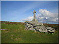
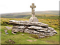
494m SE 138° Ouldsbroom Cross* Ancient Cross (SX6850173504)
706m SE 131° Sherril Down Multiple Stone Rows / Avenue (SX687734)
723m SW 229° Yar Tor Prehistoric Homestead* Ancient Village or Settlement (SX67627342)
939m NNE 24° Corndon Down N Cairns* Barrow Cemetery (SX68587473)
1.1km SE 125° Sherberton Common Multiple Stone Rows / Avenue (SX691732)
1.4km NNW 339° Sherwell Long Barrow* Long Barrow (SX677752)
2.2km S 188° Aller Brook* Cist (SX67807168)
2.3km S 181° Holne Moor North Ring Cairn (SX68097162)
2.3km W 267° Huccaby Rings Inner* Ancient Village or Settlement (SX6585473819)
2.3km SSW 206° Combestone Tor* Rock Outcrop (SX671718)
2.7km W 280° Huccaby Rings Outer* Ancient Village or Settlement (SX6554474428)
2.9km SSW 193° Holne Moor* Multiple Stone Rows / Avenue (SX6743171042)
2.9km SSW 203° Holne Ridge 5* Cairn (SX66967120)
3.0km SSW 203° Holne Ridge 6* Cairn (SX66927111)
3.1km SSW 201° Horn's Cross* Ancient Cross (SX66987103)
3.1km SSW 203° Holne Ridge 7* Barrow Cemetery (SX66927105)
3.1km SSW 206° Holne Ridge 2* Cairn (SX6675171091)
3.1km SSW 206° Holne Ridge NE* Multiple Stone Rows / Avenue (SX66757109)
3.1km SSW 208° Holne Ridge North* Cist (SX6664171138)
View more nearby sites and additional images


 We would like to know more about this location. Please feel free to add a brief description and any relevant information in your own language.
 Wir möchten mehr über diese Stätte erfahren. Bitte zögern Sie nicht, eine kurze Beschreibung und relevante Informationen in Deutsch hinzuzufügen.
 Nous aimerions en savoir encore un peu sur les lieux. S'il vous plaît n'hesitez pas à ajouter une courte description et tous les renseignements pertinents dans votre propre langue.
 Quisieramos informarnos un poco más de las lugares. No dude en añadir una breve descripción y otros datos relevantes en su propio idioma.