

<< Our Photo Pages >> Ouldsbroom Cross - Ancient Cross in England in Devon
Submitted by AngieLake on Tuesday, 01 March 2005 Page Views: 5295
Early Medieval (Dark Age)Site Name: Ouldsbroom Cross Alternative Name: Ollsbrim CrossCountry: England County: Devon Type: Ancient Cross
Nearest Town: Ashburton Nearest Village: Dartmeet
Map Ref: SX6850173504
Latitude: 50.546472N Longitude: 3.857348W
Condition:
| 5 | Perfect |
| 4 | Almost Perfect |
| 3 | Reasonable but with some damage |
| 2 | Ruined but still recognisable as an ancient site |
| 1 | Pretty much destroyed, possibly visible as crop marks |
| 0 | No data. |
| -1 | Completely destroyed |
| 5 | Superb |
| 4 | Good |
| 3 | Ordinary |
| 2 | Not Good |
| 1 | Awful |
| 0 | No data. |
| 5 | Can be driven to, probably with disabled access |
| 4 | Short walk on a footpath |
| 3 | Requiring a bit more of a walk |
| 2 | A long walk |
| 1 | In the middle of nowhere, a nightmare to find |
| 0 | No data. |
| 5 | co-ordinates taken by GPS or official recorded co-ordinates |
| 4 | co-ordinates scaled from a detailed map |
| 3 | co-ordinates scaled from a bad map |
| 2 | co-ordinates of the nearest village |
| 1 | co-ordinates of the nearest town |
| 0 | no data |
Internal Links:
External Links:
I have visited· I would like to visit
PAB would like to visit
TheCaptain visited on 11th Apr 2019 - their rating: Cond: 3 Amb: 4 Access: 5
AngieLake have visited here
")
Travelling from Poundsgate to Dartmeet, and after reaching the higher ground and passing a carpark on your left, you will see a quaint old farm house (with a modern barn) on your right, which I am almost sure has a sign reading 'Babeny' (stables?) attached to it. (Babeny itself is a couple of miles to the right from there.) Looking at the map, this would be 'Ollsbrim' farm. There are two turnings to the right coming up, and you could use either. Just past the farm is a narrow road leading off to the right, which is signposted 'Sherrill, Babeny'. If you take that one, you can turn almost immediately left again, and the cross is down that road on the left, adjacent to the road you were on earlier. Or, carry on along the road, turning sharp right at the second turning, and the cross is beside you. Coming up the steep hill from Dartmeet to Poundsgate, you will have reached the high ground, and passed a carpark on your right, close to Sharp Tor (like its name, unmissable - also to the right of the road). The first turning to your left after that (takes you to Widecombe via Ponsworthy, or again, Sherrill, Babeny) is immediately next to the cross, on the junction of those roads. I parked and walked to it from the Sharp Tor carpark.
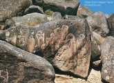
Although rather a sorry sight now, it is in a very scenic spot. Harry Starkey writes:
"In Crossing's day it stood at Town Farm, Leusdon, doing duty as a gatepost. It was still in the same position when Masson Phillips wrote in 1937. The cross was restored to its present and probably original position in the 1950s. The cross is a tall one, nearly six feet tall I should think, and rude as to construction. To facilitate its use as a gatepost, both arms were knocked off and are still missing. According to Crossing this desecration took place in 1825, the cross being conveyed to the farm, which is about two miles distant, on a sledge drawn by four oxen. The place where the cross stands is also named Ouldsbroom Cross and a farm of the same name is about a quarter of a mile away to the east. The Coffin Stone is also about a quarter of a mile distant, to the SW, about a hundred yards south of the road. There is no doubt in my mind that Ouldsbroom Cross stands in its proper position marking the path to Widecombe Church."
(These were known as 'lich paths' or 'lich ways'. Crossing writes of 'The Lich Path' that linked early settlements on the east of Dartmoor with distant Lydford church, where they had to carry the coffins of their dead for burial. Later the rules were changed to allow them to go to Widecombe church instead, which was about 8 miles closer!)
Crossing adds to this:
"There is mention of John, of Ollesbrom in the fourteenth century, and that is probably the correct form of the name."
You may be viewing yesterday's version of this page. To see the most up to date information please register for a free account.
")
")
")
")
")
")
Do not use the above information on other web sites or publications without permission of the contributor.
Click here to see more info for this site
Nearby sites
Key: Red: member's photo, Blue: 3rd party photo, Yellow: other image, Green: no photo - please go there and take one, Grey: site destroyed
Download sites to:
KML (Google Earth)
GPX (GPS waypoints)
CSV (Garmin/Navman)
CSV (Excel)
To unlock full downloads you need to sign up as a Contributory Member. Otherwise downloads are limited to 50 sites.
Turn off the page maps and other distractions
Nearby sites listing. In the following links * = Image available
224m ESE 116° Sherril Down Multiple Stone Rows / Avenue (SX687734)
482m NW 317° Money Pit cairn* Stone Circle (SX6818173865)
492m NW 312° Money Pit Cairns* Cairn (SX68147384)
494m NW 318° Yar Tor SE* Multiple Stone Rows / Avenue (SX68187388)
670m ESE 116° Sherberton Common Multiple Stone Rows / Avenue (SX691732)
692m NW 320° Yar Tor NW* Multiple Stone Rows / Avenue (SX6806674043)
698m N 3° Corndon Down Cairns* Barrow Cemetery (SX68557420)
774m WNW 303° Yar Tor Summit* Cairn (SX67867394)
843m NW 307° Yar Tor Enclosure* Causewayed Enclosure (SX67847403)
882m W 263° Yar Tor Prehistoric Homestead* Ancient Village or Settlement (SX67627342)
1.2km N 2° Corndon Down N Cairns* Barrow Cemetery (SX68587473)
1.9km NNW 333° Sherwell Long Barrow* Long Barrow (SX677752)
1.9km S 191° Holne Moor North Ring Cairn (SX68097162)
2.0km SSW 200° Aller Brook* Cist (SX67807168)
2.2km SW 218° Combestone Tor* Rock Outcrop (SX671718)
2.7km W 275° Huccaby Rings Inner* Ancient Village or Settlement (SX6585473819)
2.7km SSW 202° Holne Moor* Multiple Stone Rows / Avenue (SX6743171042)
2.8km SSW 212° Holne Ridge 5* Cairn (SX66967120)
2.9km SSW 212° Holne Ridge 6* Cairn (SX66927111)
2.9km SSW 210° Horn's Cross* Ancient Cross (SX66987103)
2.9km SSW 211° Holne Ridge 7* Barrow Cemetery (SX66927105)
3.0km SW 214° Holne Ridge 2* Cairn (SX6675171091)
3.0km SW 214° Holne Ridge NE* Multiple Stone Rows / Avenue (SX66757109)
3.0km SW 217° Holne Ridge North* Cist (SX6664171138)
3.1km WNW 286° Huccaby Rings Outer* Ancient Village or Settlement (SX6554474428)
View more nearby sites and additional images


 We would like to know more about this location. Please feel free to add a brief description and any relevant information in your own language.
 Wir möchten mehr über diese Stätte erfahren. Bitte zögern Sie nicht, eine kurze Beschreibung und relevante Informationen in Deutsch hinzuzufügen.
 Nous aimerions en savoir encore un peu sur les lieux. S'il vous plaît n'hesitez pas à ajouter une courte description et tous les renseignements pertinents dans votre propre langue.
 Quisieramos informarnos un poco más de las lugares. No dude en añadir una breve descripción y otros datos relevantes en su propio idioma.