

<< Our Photo Pages >> Bargloyer Steinkiste - Chambered Tomb in Germany in Lower Saxony, Bremen
Submitted by AlexHunger on Sunday, 30 October 2005 Page Views: 3402
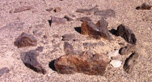
Neolithic and Bronze AgeSite Name: Bargloyer SteinkisteCountry: Germany Land: Lower Saxony, Bremen Type: Chambered Tomb
Nearest Town: Bremen Nearest Village: Bargloy
Latitude: 52.888883N Longitude: 8.392102E
Condition:
| 5 | Perfect |
| 4 | Almost Perfect |
| 3 | Reasonable but with some damage |
| 2 | Ruined but still recognisable as an ancient site |
| 1 | Pretty much destroyed, possibly visible as crop marks |
| 0 | No data. |
| -1 | Completely destroyed |
| 5 | Superb |
| 4 | Good |
| 3 | Ordinary |
| 2 | Not Good |
| 1 | Awful |
| 0 | No data. |
| 5 | Can be driven to, probably with disabled access |
| 4 | Short walk on a footpath |
| 3 | Requiring a bit more of a walk |
| 2 | A long walk |
| 1 | In the middle of nowhere, a nightmare to find |
| 0 | No data. |
| 5 | co-ordinates taken by GPS or official recorded co-ordinates |
| 4 | co-ordinates scaled from a detailed map |
| 3 | co-ordinates scaled from a bad map |
| 2 | co-ordinates of the nearest village |
| 1 | co-ordinates of the nearest town |
| 0 | no data |
Internal Links:
External Links:
I have visited· I would like to visit
CharcoalBurner89 visited on 19th Oct 2021 - their rating: Cond: 3 Amb: 3 Access: 4 Well-preserved stone box from the Bronze Age. Here the capstone shows cups.
Autun visited on 11th Aug 2021 - their rating: Cond: 3 Amb: 3 Access: 4 A surprisingly small capstone on top of a sizable mound.
johnstone visited on 7th Sep 2017 - their rating: Cond: 3 Amb: 3 Access: 4
Martin_L have visited here
Average ratings for this site from all visit loggers: Condition: 3 Ambience: 3 Access: 4
")
Positional co-ordinates scaled from a map source. 2 Meter by 1.5 Meter early bronze age Chambered tomb
You may be viewing yesterday's version of this page. To see the most up to date information please register for a free account.
")
")
")
")
")
")
")
")
")
")
")
")
")
")
")
")
")
")
")
")
")
")
")
Do not use the above information on other web sites or publications without permission of the contributor.
Click here to see more info for this site
Nearby sites
Click here to view sites on an interactive map of the areaKey: Red: member's photo, Blue: 3rd party photo, Yellow: other image, Green: no photo - please go there and take one, Grey: site destroyed
Download sites to:
KML (Google Earth)
GPX (GPS waypoints)
CSV (Garmin/Navman)
CSV (Excel)
To unlock full downloads you need to sign up as a Contributory Member. Otherwise downloads are limited to 50 sites.
Turn off the page maps and other distractions
Nearby sites listing. In the following links * = Image available
1.1km NNE 25° Bargloyer Brookbäke Grab (4)* Round Barrow(s)
1.1km NNE 22° Bargloyer Brookbäke Steingrab (2)* Chambered Tomb
1.1km NNE 23° Bargloyer Brookbäke Steingrab (3)* Chambered Tomb
1.1km N 9° Bargloyer Brookbäke Steingrab (1)* Chambered Tomb
1.3km NW 322° Wildeshausen Hohe Steine* Chambered Tomb
1.6km W 272° Holzhausen Kellersteine Grab 2* Chambered Tomb
2.0km W 276° Holzhausen Kellersteine Grab 1* Chambered Tomb
3.8km WSW 257° Thoelstedt Steingrab* Chambered Tomb
4.1km SE 134° Kleinenkneter Steine 1* Chambered Tomb
4.2km ESE 112° Pestruper Gräberfeld* Barrow Cemetery
4.2km SE 133° Wellohsberg Steingrab* Chambered Tomb
4.2km SE 134° Kleinenkneter Steine 2* Passage Grave
4.3km WSW 256° Schmeersteine Huegelgrab (1)* Round Barrow(s)
4.3km WSW 258° Schmeersteine Huegelgrab (3)* Round Barrow(s)
4.3km WSW 256° Schmeersteine Huegelgrab (2)* Round Barrow(s)
4.3km WSW 255° Schmeersteine Grosssteingrab* Chambered Tomb
4.6km W 274° Visbeker Braut* Long Barrow
4.6km N 359° Doetlingen-Badberg Steingrab Chambered Tomb
4.7km NNW 345° Glaner Braut 3* Chambered Tomb
4.7km WSW 249° Varnhorn Muehlensteine* Chambered Tomb
4.7km NNW 346° Glaner Braut 2* Chambered Tomb
4.8km NNW 345° Glaner Braut 1* Chambered Tomb
4.8km NNW 345° Glaner Braut 4* Chambered Tomb
5.2km SSE 153° Kleinenkneten Steingrab 3 Chambered Tomb
5.2km NNE 14° Gerichtsstaette Steingrab* Chambered Tomb
View more nearby sites and additional images


 We would like to know more about this location. Please feel free to add a brief description and any relevant information in your own language.
 Wir möchten mehr über diese Stätte erfahren. Bitte zögern Sie nicht, eine kurze Beschreibung und relevante Informationen in Deutsch hinzuzufügen.
 Nous aimerions en savoir encore un peu sur les lieux. S'il vous plaît n'hesitez pas à ajouter une courte description et tous les renseignements pertinents dans votre propre langue.
 Quisieramos informarnos un poco más de las lugares. No dude en añadir una breve descripción y otros datos relevantes en su propio idioma.