 with our Megalithic Portal iPhone app")

<< Our Photo Pages >> Gerichtsstaette Steingrab - Chambered Tomb in Germany in Lower Saxony, Bremen
Submitted by Martin_L on Tuesday, 11 May 2010 Page Views: 2860
Neolithic and Bronze AgeSite Name: Gerichtsstaette Steingrab Alternative Name: Sprockhoff 945, Gerichtsstätte GroßsteingrabCountry: Germany Land: Lower Saxony, Bremen Type: Chambered Tomb
Nearest Town: Wildeshausen Nearest Village: Dötlingen Aschenbeck
Latitude: 52.934380N Longitude: 8.410230E
Condition:
| 5 | Perfect |
| 4 | Almost Perfect |
| 3 | Reasonable but with some damage |
| 2 | Ruined but still recognisable as an ancient site |
| 1 | Pretty much destroyed, possibly visible as crop marks |
| 0 | No data. |
| -1 | Completely destroyed |
| 5 | Superb |
| 4 | Good |
| 3 | Ordinary |
| 2 | Not Good |
| 1 | Awful |
| 0 | No data. |
| 5 | Can be driven to, probably with disabled access |
| 4 | Short walk on a footpath |
| 3 | Requiring a bit more of a walk |
| 2 | A long walk |
| 1 | In the middle of nowhere, a nightmare to find |
| 0 | No data. |
| 5 | co-ordinates taken by GPS or official recorded co-ordinates |
| 4 | co-ordinates scaled from a detailed map |
| 3 | co-ordinates scaled from a bad map |
| 2 | co-ordinates of the nearest village |
| 1 | co-ordinates of the nearest town |
| 0 | no data |
Internal Links:
External Links:
I have visited· I would like to visit
CharcoalBurner89 visited on 18th Oct 2021 - their rating: Cond: 3 Amb: 3 Access: 4 Judgment was often held here in the village. Therefore the name. Otherwise, the system is poorly preserved, even if it is still clearly recognizable.
johnstone visited on 4th Sep 2017 - their rating: Cond: 2 Amb: 3 Access: 4
Martin_L have visited here
Average ratings for this site from all visit loggers: Condition: 2.5 Ambience: 3 Access: 4
")
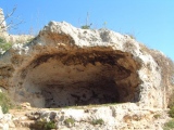
Just to the South of these remaining chamber part a capstone is lying turned upside down. According to the research of Sprockhoff et al. the chamber has preserved all orthostats except for the Southern chamber-endstone and the southernmost orthostat of the eastern side . In consequence chambers' original size would have been approx. 6m x 3,5m (clear size approx. 4m x 1,5m). However as the southern chamber end is uncertain and also the shape of the earthwork is hard to determine it of course is hard to prove this thesis without data from excavation. There also is no data regarding a possible enclosure. The sites' name “Gerichtstätte” could be translated as “place of tribunal” deriving from the local use in historic times.
The tomb is nicely situated inside a small wood, but next to the village. The next house is just twenty metres away. It could be an excellent site if someone would decide to put the remaining capstone back on its orthostats.
Reference: Sprockhoff, Schwieger in: Körner, G. (Ed.), Sprockhoff, E. Atlas der Megalithgräber Deutschlands, Teil 3: Niedersachsen-Westfalen, Habelt, Bonn, 1975, p. 135, Atlasblatt 158
You may be viewing yesterday's version of this page. To see the most up to date information please register for a free account.
")
")
")
")
")
")
")
")
Do not use the above information on other web sites or publications without permission of the contributor.
Click here to see more info for this site
Nearby sites
Click here to view sites on an interactive map of the areaKey: Red: member's photo, Blue: 3rd party photo, Yellow: other image, Green: no photo - please go there and take one, Grey: site destroyed
Download sites to:
KML (Google Earth)
GPX (GPS waypoints)
CSV (Garmin/Navman)
CSV (Excel)
To unlock full downloads you need to sign up as a Contributory Member. Otherwise downloads are limited to 50 sites.
Turn off the page maps and other distractions
Nearby sites listing. In the following links * = Image available
1.3km WSW 250° Doetlingen-Badberg Steingrab Chambered Tomb
1.9km W 280° Doetlingen Steenbarg Chambered Tomb
2.1km WNW 286° Doetlingen Steingrab* Passage Grave
2.4km W 259° Glaner Braut 2* Chambered Tomb
2.5km W 261° Glaner Braut 4* Chambered Tomb
2.5km W 260° Glaner Braut 1* Chambered Tomb
2.5km WSW 258° Glaner Braut 3* Chambered Tomb
4.1km SSW 195° Bargloyer Brookbäke Steingrab (1)* Chambered Tomb
4.1km S 191° Bargloyer Brookbäke Steingrab (3)* Chambered Tomb
4.1km SSW 191° Bargloyer Brookbäke Steingrab (2)* Chambered Tomb
4.2km S 191° Bargloyer Brookbäke Grab (4)* Round Barrow(s)
4.2km NW 309° Egypten Steingrab* Chambered Tomb
4.5km SSW 207° Wildeshausen Hohe Steine* Chambered Tomb
5.2km SSW 194° Bargloyer Steinkiste* Chambered Tomb
5.3km NNW 335° Ohe 'Die Berge' Huegelgraeberfeld* Barrow Cemetery
5.7km SSW 209° Holzhausen Kellersteine Grab 2* Chambered Tomb
5.8km SSW 214° Holzhausen Kellersteine Grab 1* Chambered Tomb
6.1km NNW 342° Neerstedt Hexenstein* Rock Art
7.1km SSE 158° Pestruper Gräberfeld* Barrow Cemetery
7.5km SW 231° Visbeker Braut* Long Barrow
7.7km SW 220° Thoelstedt Steingrab* Chambered Tomb
7.7km SE 144° Ruedebusch Huegelgraeberfeld* Barrow Cemetery
7.9km W 274° Hespenbusch Hügelgräberfeld* Barrow Cemetery
8.0km SW 222° Schmeersteine Huegelgrab (3)* Round Barrow(s)
8.1km SSE 168° Kleinenkneter Steine 1* Chambered Tomb
View more nearby sites and additional images


 We would like to know more about this location. Please feel free to add a brief description and any relevant information in your own language.
 Wir möchten mehr über diese Stätte erfahren. Bitte zögern Sie nicht, eine kurze Beschreibung und relevante Informationen in Deutsch hinzuzufügen.
 Nous aimerions en savoir encore un peu sur les lieux. S'il vous plaît n'hesitez pas à ajouter une courte description et tous les renseignements pertinents dans votre propre langue.
 Quisieramos informarnos un poco más de las lugares. No dude en añadir una breve descripción y otros datos relevantes en su propio idioma.