
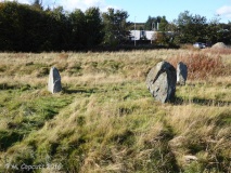

<< Our Photo Pages >> Raes Of Clune - Stone Circle in Scotland in Aberdeenshire
Submitted by cosmic on Monday, 11 November 2002 Page Views: 8495
Neolithic and Bronze AgeSite Name: Raes Of Clune Alternative Name: Clune WoodsCountry: Scotland County: Aberdeenshire Type: Stone Circle
Map Ref: NO7946894949 Landranger Map Number: 38
Latitude: 57.045157N Longitude: 2.340018W
Condition:
| 5 | Perfect |
| 4 | Almost Perfect |
| 3 | Reasonable but with some damage |
| 2 | Ruined but still recognisable as an ancient site |
| 1 | Pretty much destroyed, possibly visible as crop marks |
| 0 | No data. |
| -1 | Completely destroyed |
| 5 | Superb |
| 4 | Good |
| 3 | Ordinary |
| 2 | Not Good |
| 1 | Awful |
| 0 | No data. |
| 5 | Can be driven to, probably with disabled access |
| 4 | Short walk on a footpath |
| 3 | Requiring a bit more of a walk |
| 2 | A long walk |
| 1 | In the middle of nowhere, a nightmare to find |
| 0 | No data. |
| 5 | co-ordinates taken by GPS or official recorded co-ordinates |
| 4 | co-ordinates scaled from a detailed map |
| 3 | co-ordinates scaled from a bad map |
| 2 | co-ordinates of the nearest village |
| 1 | co-ordinates of the nearest town |
| 0 | no data |
Internal Links:
External Links:
I have visited· I would like to visit
Chrus visited on 1st Jan 0000 - their rating: Cond: 3 Amb: 5 Access: 3
")
Nearby is a large cairn
You may be viewing yesterday's version of this page. To see the most up to date information please register for a free account.
")
")
")
")
")
")
")
")
")
")
")
Do not use the above information on other web sites or publications without permission of the contributor.
Click here to see more info for this site
Nearby sites
Key: Red: member's photo, Blue: 3rd party photo, Yellow: other image, Green: no photo - please go there and take one, Grey: site destroyed
Download sites to:
KML (Google Earth)
GPX (GPS waypoints)
CSV (Garmin/Navman)
CSV (Excel)
To unlock full downloads you need to sign up as a Contributory Member. Otherwise downloads are limited to 50 sites.
Turn off the page maps and other distractions
Nearby sites listing. In the following links * = Image available
149m NW 305° Clune Wood* Cairn (NO7934695036)
1.3km ESE 110° Elsick Mounth* Ancient Trackway (NO807945)
1.9km E 88° South Brachmont Artificial Mound (NO814950)
3.1km NNW 331° Park House* Class I Pictish Symbol Stone (NO77979765)
3.3km SSW 202° Cairn-mon-earn* Cairn (NO782919)
4.1km WSW 258° Cairnfauld* Stone Circle (NO754941)
5.0km SE 145° Auquhollie* Standing Stone (Menhir) (NO82339080)
5.4km W 267° Barns Enclosure Ancient Village or Settlement (NO741947)
5.5km WNW 282° Milton of Crathes* Class I Pictish Symbol Stone (NO741961)
5.6km WSW 257° Cairnshee Wood* Cairn (NO740937)
5.7km W 261° Cairnshee Enclosure Souterrain (Fogou, Earth House) (NO738941)
5.7km SE 139° Raedykes NW* Stone Circle (NO832906)
5.8km WNW 287° Warren Field* Ancient Village or Settlement (NO73939670)
5.8km SE 140° Raedykes SE* Stone Circle (NO832905)
5.8km SE 140° Campstone Hill Ring Cairn (NO832905)
5.8km ENE 64° Standingstones* Standing Stones (NO847975)
6.2km W 278° Balbridie Neolithic Timber Hall Ancient Village or Settlement (NO733959)
6.6km WSW 246° East Mulloch Stone Circle (NO734923)
6.7km SE 135° Raedykes Roman Camp* Hillfort (NO842902)
6.9km SSE 155° Glenton Hill Enclosure Ancient Village or Settlement (NO823887)
7.0km W 262° Tilquhillie Stone Circle (Remains)* Stone Circle (NO72529402)
7.0km WSW 241° Westerton Hut Circle Ancient Village or Settlement (NO733916)
7.3km SE 137° Newbigging Earthwork Ancient Village or Settlement (NO844896)
7.3km W 263° Tilquhillie Standing Stone* Standing Stone (Menhir) (NO72239410)
7.6km S 173° Clochanshiels Ancient Village or Settlement (NO803874)
View more nearby sites and additional images


 We would like to know more about this location. Please feel free to add a brief description and any relevant information in your own language.
 Wir möchten mehr über diese Stätte erfahren. Bitte zögern Sie nicht, eine kurze Beschreibung und relevante Informationen in Deutsch hinzuzufügen.
 Nous aimerions en savoir encore un peu sur les lieux. S'il vous plaît n'hesitez pas à ajouter une courte description et tous les renseignements pertinents dans votre propre langue.
 Quisieramos informarnos un poco más de las lugares. No dude en añadir una breve descripción y otros datos relevantes en su propio idioma.