<< Our Photo Pages >> Tilquhillie Standing Stone - Standing Stone (Menhir) in Scotland in Aberdeenshire
Submitted by cosmic on Tuesday, 31 March 2009 Page Views: 6822
Neolithic and Bronze AgeSite Name: Tilquhillie Standing Stone Alternative Name: Recumbent Stone CircleCountry: Scotland County: Aberdeenshire Type: Standing Stone (Menhir)
Nearest Town: Banchory
Map Ref: NO72239410
Latitude: 57.037150N Longitude: 2.45921W
Condition:
| 5 | Perfect |
| 4 | Almost Perfect |
| 3 | Reasonable but with some damage |
| 2 | Ruined but still recognisable as an ancient site |
| 1 | Pretty much destroyed, possibly visible as crop marks |
| 0 | No data. |
| -1 | Completely destroyed |
| 5 | Superb |
| 4 | Good |
| 3 | Ordinary |
| 2 | Not Good |
| 1 | Awful |
| 0 | No data. |
| 5 | Can be driven to, probably with disabled access |
| 4 | Short walk on a footpath |
| 3 | Requiring a bit more of a walk |
| 2 | A long walk |
| 1 | In the middle of nowhere, a nightmare to find |
| 0 | No data. |
| 5 | co-ordinates taken by GPS or official recorded co-ordinates |
| 4 | co-ordinates scaled from a detailed map |
| 3 | co-ordinates scaled from a bad map |
| 2 | co-ordinates of the nearest village |
| 1 | co-ordinates of the nearest town |
| 0 | no data |
Internal Links:
External Links:
")
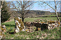
This stone is situated in a gap in a consumption dyke near Tilquhillie Castle. (A consumption dyke is a extra thick, high stone wall made to use up the stones cleared off the fields; nearer Aberdeen the stones were actually carted down to the harbour and "exported" to places like London).
Depite the alternative name RCAHMS insist there is no evidence to suggest it was part of a circle.
It is given as 1.7m tall.
You may be viewing yesterday's version of this page. To see the most up to date information please register for a free account.
")
")
Do not use the above information on other web sites or publications without permission of the contributor.
Nearby Images from Geograph Britain and Ireland:
©2015(licence)
©2009(licence)
©2009(licence)
©2006(licence)
©2009(licence)
The above images may not be of the site on this page, they are loaded from Geograph.
Please Submit an Image of this site or go out and take one for us!
Click here to see more info for this site
Nearby sites
Key: Red: member's photo, Blue: 3rd party photo, Yellow: other image, Green: no photo - please go there and take one, Grey: site destroyed
Download sites to:
KML (Google Earth)
GPX (GPS waypoints)
CSV (Garmin/Navman)
CSV (Excel)
To unlock full downloads you need to sign up as a Contributory Member. Otherwise downloads are limited to 50 sites.
Turn off the page maps and other distractions
Nearby sites listing. In the following links * = Image available
300m ESE 105° Tilquhillie Stone Circle (Remains)* Stone Circle (NO72529402)
1.6km E 90° Cairnshee Enclosure Souterrain (Fogou, Earth House) (NO738941)
1.8km ESE 102° Cairnshee Wood* Cairn (NO740937)
1.9km S 179° Esslie The Lesser* Stone Circle (NO72259215)
2.0km ENE 72° Barns Enclosure Ancient Village or Settlement (NO741947)
2.1km NNE 30° Balbridie Neolithic Timber Hall Ancient Village or Settlement (NO733959)
2.1km SSE 147° East Mulloch Stone Circle (NO734923)
2.6km S 191° Esslie The Greater* Stone Circle (NO71729159)
2.7km SSE 156° Westerton Hut Circle Ancient Village or Settlement (NO733916)
2.7km NE 43° Milton of Crathes* Class I Pictish Symbol Stone (NO741961)
2.9km S 176° Garrol Wood* Stone Circle (NO72409117)
3.1km NNE 33° Warren Field* Ancient Village or Settlement (NO73939670)
3.2km E 90° Cairnfauld* Stone Circle (NO754941)
3.5km S 183° Midtown Ancient Village or Settlement (NO720906)
3.9km S 190° Midtown Ancient Village or Settlement (NO715903)
4.5km WNW 297° Inchmarlo* Standing Stone (Menhir) (NO68249613)
6.3km ESE 110° Cairn-mon-earn* Cairn (NO782919)
6.4km W 260° Bucharn* Round Cairn (NO65949300)
6.7km ENE 58° Park House* Class I Pictish Symbol Stone (NO77979765)
7.2km E 82° Clune Wood* Cairn (NO7934695036)
7.3km E 83° Raes Of Clune* Stone Circle (NO7946894949)
8.5km E 87° Elsick Mounth* Ancient Trackway (NO807945)
9.2km E 84° South Brachmont Artificial Mound (NO814950)
9.2km NW 307° Glassel* Stone Circle (NO64909969)
10.5km SE 129° Clochanshiels Ancient Village or Settlement (NO803874)
View more nearby sites and additional images


 We would like to know more about this location. Please feel free to add a brief description and any relevant information in your own language.
 Wir möchten mehr über diese Stätte erfahren. Bitte zögern Sie nicht, eine kurze Beschreibung und relevante Informationen in Deutsch hinzuzufügen.
 Nous aimerions en savoir encore un peu sur les lieux. S'il vous plaît n'hesitez pas à ajouter une courte description et tous les renseignements pertinents dans votre propre langue.
 Quisieramos informarnos un poco más de las lugares. No dude en añadir una breve descripción y otros datos relevantes en su propio idioma.