<< Our Photo Pages >> Tilquhillie Stone Circle (Remains) - Stone Circle in Scotland in Aberdeenshire
Submitted by hamilton on Monday, 16 January 2012 Page Views: 8894
Neolithic and Bronze AgeSite Name: Tilquhillie Stone Circle (Remains) Alternative Name: The Druid StoneCountry: Scotland County: Aberdeenshire Type: Stone Circle
Map Ref: NO72529402 Landranger Map Number: 38
Latitude: 57.036449N Longitude: 2.454423W
Condition:
| 5 | Perfect |
| 4 | Almost Perfect |
| 3 | Reasonable but with some damage |
| 2 | Ruined but still recognisable as an ancient site |
| 1 | Pretty much destroyed, possibly visible as crop marks |
| 0 | No data. |
| -1 | Completely destroyed |
| 5 | Superb |
| 4 | Good |
| 3 | Ordinary |
| 2 | Not Good |
| 1 | Awful |
| 0 | No data. |
| 5 | Can be driven to, probably with disabled access |
| 4 | Short walk on a footpath |
| 3 | Requiring a bit more of a walk |
| 2 | A long walk |
| 1 | In the middle of nowhere, a nightmare to find |
| 0 | No data. |
| 5 | co-ordinates taken by GPS or official recorded co-ordinates |
| 4 | co-ordinates scaled from a detailed map |
| 3 | co-ordinates scaled from a bad map |
| 2 | co-ordinates of the nearest village |
| 1 | co-ordinates of the nearest town |
| 0 | no data |
Internal Links:
External Links:
 (PID:86153)")
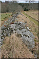
The RCAHMS book Great Crowns of Stone makes a strong case for the stone circle in the fields close to Tilquhillie Castle having been a recumbent type stone circle. The photos show the likely recumbent stone now resting, discarded, on a consumption dyke between the two fields to the SE of Tilquhillie castle.
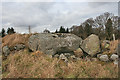
"A recumbent stone circle probably once stood in one of the improved fields to the ESE of Tilquhillie Castle, but the stones were cleared before 1855 (see below) and the recumbent, a block known as The Druid Stone (Ritchie 1919, 71), lies discarded on a consumption dyke 275m SE of the Castle (NO 7252 9402). Measuring about 2.5m in length by 1.3m in breadth and 0.8m in thickness, what was the even summit of the block now forms its WNW side. What is probably a second stone from the circle has been re-erected in a gap between another two consumption dykes 35m SW of the Castle (NO 7223 9410); it presents a strongly curved profile and stands 1.65m high."
Source: RCAHMS
Golux adds: The circle was recorded, as a ruin, by Ritchie in 1919 but in his somewhat confused description he had failed to identify the recumbent stone and had posited the nearby standing stone as a flanker to a recumbent without evidence.
You may be viewing yesterday's version of this page. To see the most up to date information please register for a free account.
 (PID:86152)")
Do not use the above information on other web sites or publications without permission of the contributor.
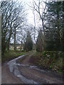
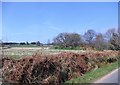
Nearby Images from Geograph Britain and Ireland:
©2016(licence)
©2016(licence)
©2006(licence)
©2014(licence)
©2017(licence)
The above images may not be of the site on this page, they are loaded from Geograph.
Please Submit an Image of this site or go out and take one for us!
Click here to see more info for this site
Nearby sites
Key: Red: member's photo, Blue: 3rd party photo, Yellow: other image, Green: no photo - please go there and take one, Grey: site destroyed
Download sites to:
KML (Google Earth)
GPX (GPS waypoints)
CSV (Garmin/Navman)
CSV (Excel)
To unlock full downloads you need to sign up as a Contributory Member. Otherwise downloads are limited to 50 sites.
Turn off the page maps and other distractions
Nearby sites listing. In the following links * = Image available
300m WNW 285° Tilquhillie Standing Stone* Standing Stone (Menhir) (NO72239410)
1.3km E 86° Cairnshee Enclosure Souterrain (Fogou, Earth House) (NO738941)
1.5km ESE 102° Cairnshee Wood* Cairn (NO740937)
1.7km ENE 66° Barns Enclosure Ancient Village or Settlement (NO741947)
1.9km S 188° Esslie The Lesser* Stone Circle (NO72259215)
1.9km SSE 153° East Mulloch Stone Circle (NO734923)
2.0km NNE 22° Balbridie Neolithic Timber Hall Ancient Village or Settlement (NO733959)
2.5km SSE 162° Westerton Hut Circle Ancient Village or Settlement (NO733916)
2.6km SSW 198° Esslie The Greater* Stone Circle (NO71729159)
2.6km NE 37° Milton of Crathes* Class I Pictish Symbol Stone (NO741961)
2.8km S 182° Garrol Wood* Stone Circle (NO72409117)
2.9km E 88° Cairnfauld* Stone Circle (NO754941)
3.0km NNE 27° Warren Field* Ancient Village or Settlement (NO73939670)
3.5km S 188° Midtown Ancient Village or Settlement (NO720906)
3.9km SSW 195° Midtown Ancient Village or Settlement (NO715903)
4.8km WNW 296° Inchmarlo* Standing Stone (Menhir) (NO68249613)
6.0km ESE 110° Cairn-mon-earn* Cairn (NO782919)
6.5km NE 56° Park House* Class I Pictish Symbol Stone (NO77979765)
6.6km W 261° Bucharn* Round Cairn (NO65949300)
6.9km E 81° Clune Wood* Cairn (NO7934695036)
7.0km E 82° Raes Of Clune* Stone Circle (NO7946894949)
8.2km E 86° Elsick Mounth* Ancient Trackway (NO807945)
8.9km E 83° South Brachmont Artificial Mound (NO814950)
9.5km NW 306° Glassel* Stone Circle (NO64909969)
10.2km SE 130° Clochanshiels Ancient Village or Settlement (NO803874)
View more nearby sites and additional images


 We would like to know more about this location. Please feel free to add a brief description and any relevant information in your own language.
 Wir möchten mehr über diese Stätte erfahren. Bitte zögern Sie nicht, eine kurze Beschreibung und relevante Informationen in Deutsch hinzuzufügen.
 Nous aimerions en savoir encore un peu sur les lieux. S'il vous plaît n'hesitez pas à ajouter une courte description et tous les renseignements pertinents dans votre propre langue.
 Quisieramos informarnos un poco más de las lugares. No dude en añadir una breve descripción y otros datos relevantes en su propio idioma.