 with our Megalithic Portal iPhone app")


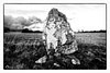
<< Text Pages >> Cromlech du Moulin du Duc - Stone Circle in France in Bretagne:Finistère (29)
Submitted by holger_rix on Wednesday, 11 May 2016 Page Views: 738
Neolithic and Bronze AgeSite Name: Cromlech du Moulin du DucCountry: France
NOTE: This site is 2.57 km away from the location you searched for.
Département: Bretagne:Finistère (29) Type: Stone Circle
Nearest Town: Châteaulin Nearest Village: Moulin Du Duc
Latitude: 48.283935N Longitude: 3.925034W
Condition:
| 5 | Perfect |
| 4 | Almost Perfect |
| 3 | Reasonable but with some damage |
| 2 | Ruined but still recognisable as an ancient site |
| 1 | Pretty much destroyed, possibly visible as crop marks |
| 0 | No data. |
| -1 | Completely destroyed |
| 5 | Superb |
| 4 | Good |
| 3 | Ordinary |
| 2 | Not Good |
| 1 | Awful |
| 0 | No data. |
| 5 | Can be driven to, probably with disabled access |
| 4 | Short walk on a footpath |
| 3 | Requiring a bit more of a walk |
| 2 | A long walk |
| 1 | In the middle of nowhere, a nightmare to find |
| 0 | No data. |
| 5 | co-ordinates taken by GPS or official recorded co-ordinates |
| 4 | co-ordinates scaled from a detailed map |
| 3 | co-ordinates scaled from a bad map |
| 2 | co-ordinates of the nearest village |
| 1 | co-ordinates of the nearest town |
| 0 | no data |
Be the first person to rate this site - see the 'Contribute!' box in the right hand menu.
Internal Links:
External Links:
Stone Circle in Bretagne:Finistère (29)
Coat Caër, Lannédern, Châteaulin, Finistère, Brittany
Source: T4T35
Information and Pictures:
t4t35.fr
You may be viewing yesterday's version of this page. To see the most up to date information please register for a free account.
Do not use the above information on other web sites or publications without permission of the contributor.
Nearby Images from Flickr
The above images may not be of the site on this page, but were taken nearby. They are loaded from Flickr so please click on them for image credits.
Click here to see more info for this site
Nearby sites
Click here to view sites on an interactive map of the areaKey: Red: member's photo, Blue: 3rd party photo, Yellow: other image, Green: no photo - please go there and take one, Grey: site destroyed
Download sites to:
KML (Google Earth)
GPX (GPS waypoints)
CSV (Garmin/Navman)
CSV (Excel)
To unlock full downloads you need to sign up as a Contributory Member. Otherwise downloads are limited to 50 sites.
Turn off the page maps and other distractions
Nearby sites listing. In the following links * = Image available
6.6km NNE 18° Roc'h Cléguer menhir* Standing Stone (Menhir)
6.9km N 356° An-Eured-Ven* Stone Row / Alignment
8.2km NE 56° Allée couverte de Be Keor Passage Grave
8.5km NNW 338° Le Rocher du Diable* Standing Stone (Menhir)
9.9km NE 35° Brennilis Menhirs* Standing Stones
10.1km SSW 200° Allée Couverte dite Loch-ar-Ronfl* Passage Grave
10.4km NNE 33° Ty ar Boudiquet Dolmen* Burial Chamber or Dolmen
10.6km NE 38° Menhir de Kermorvan Standing Stone (Menhir)
10.8km S 179° Dolmen de Pendréau* Burial Chamber or Dolmen
11.5km NE 46° Leintant menhir* Standing Stone (Menhir)
11.5km NE 46° Alignement de Leintant Stone Row / Alignment
11.9km NE 50° Menhir du Roz Perez* Standing Stone (Menhir)
12.1km NE 45° Dolmen de Coat Mocun Burial Chamber or Dolmen
12.1km NNE 32° Tumulus de Kerelcan* Round Barrow(s)
12.2km NE 48° Dolmen de Plouénez Burial Chamber or Dolmen
12.5km NE 47° Menhir de Coat Mocoun (sud)* Standing Stone (Menhir)
12.6km NE 46° Menhir de Coatmocun (Huelgoat)* Standing Stone (Menhir)
12.6km NE 35° Kerelcun Menhir* Standing Stone (Menhir)
12.7km NE 45° Coatmocun north menhir Standing Stone (Menhir)
12.7km ENE 60° Menhir de Kervic Standing Stone (Menhir)
12.8km NE 46° Menhir de Coatmocun * Standing Stone (Menhir)
12.9km NE 51° St-Guinec menhir* Standing Stone (Menhir)
13.2km NNW 347° Mougau Bihan* Passage Grave
14.4km S 174° Tumulus de Ty-Floc'h* Chambered Cairn
14.6km N 2° Dolmen de Keradalan Burial Chamber or Dolmen
View more nearby sites and additional images


 We would like to know more about this location. Please feel free to add a brief description and any relevant information in your own language.
 Wir möchten mehr über diese Stätte erfahren. Bitte zögern Sie nicht, eine kurze Beschreibung und relevante Informationen in Deutsch hinzuzufügen.
 Nous aimerions en savoir encore un peu sur les lieux. S'il vous plaît n'hesitez pas à ajouter une courte description et tous les renseignements pertinents dans votre propre langue.
 Quisieramos informarnos un poco más de las lugares. No dude en añadir una breve descripción y otros datos relevantes en su propio idioma.