

<< Our Photo Pages >> Picardy Stone - Class I Pictish Symbol Stone in Scotland in Aberdeenshire
Submitted by jeffrep on Thursday, 21 February 2008 Page Views: 17307
Early Medieval (Dark Age)Site Name: Picardy Stone Alternative Name: Myreton Farm, InschCountry: Scotland
NOTE: This site is 0.126 km away from the location you searched for.
County: Aberdeenshire Type: Class I Pictish Symbol Stone
Nearest Town: Aberdeen Nearest Village: Insch
Map Ref: NJ60993026 Landranger Map Number: 29
Latitude: 57.361136N Longitude: 2.65009W
Condition:
| 5 | Perfect |
| 4 | Almost Perfect |
| 3 | Reasonable but with some damage |
| 2 | Ruined but still recognisable as an ancient site |
| 1 | Pretty much destroyed, possibly visible as crop marks |
| 0 | No data. |
| -1 | Completely destroyed |
| 5 | Superb |
| 4 | Good |
| 3 | Ordinary |
| 2 | Not Good |
| 1 | Awful |
| 0 | No data. |
| 5 | Can be driven to, probably with disabled access |
| 4 | Short walk on a footpath |
| 3 | Requiring a bit more of a walk |
| 2 | A long walk |
| 1 | In the middle of nowhere, a nightmare to find |
| 0 | No data. |
| 5 | co-ordinates taken by GPS or official recorded co-ordinates |
| 4 | co-ordinates scaled from a detailed map |
| 3 | co-ordinates scaled from a bad map |
| 2 | co-ordinates of the nearest village |
| 1 | co-ordinates of the nearest town |
| 0 | no data |
Internal Links:
External Links:
I have visited· I would like to visit
radrad would like to visit
SolarMegalith visited on 18th Feb 2018 - their rating: Cond: 4 Amb: 4 Access: 5
SandyG visited on 22nd Sep 2013 - their rating: Cond: 4 Amb: 2 Access: 5
megalithicmatt visited on 1st Jan 2009 - their rating: Cond: 4 Amb: 3 Access: 5 Good stone, pity about the metal railing surround.
Klingon visited - their rating: Cond: 5 Amb: 5 Access: 5
NickyD jeffrep HaggisAction have visited here
Average ratings for this site from all visit loggers: Condition: 4.25 Ambience: 3.5 Access: 5
")
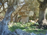
The Picardy Stone has the following symbols carved into it: the double disc and Z-rod; the serpent and Z-rod; and the mirror. When excavated in the 19th Century, it was found that the stone was set in a cairn beneath which was a rectangular grave.
The Picardy Symbol Stone is located between Huntly and Inverurie off the B9002 on a beautiful tree-lined minor road north of the village of Insch in Aberdeenshire in Scotland.
For details, visit: http://www.archaeoptics.co.uk/products/ecms/326.html
You may be viewing yesterday's version of this page. To see the most up to date information please register for a free account.
")
")
")
")
")
")
")
")
")
")
")
")
")
")
")
Do not use the above information on other web sites or publications without permission of the contributor.
Click here to see more info for this site
Nearby sites
Key: Red: member's photo, Blue: 3rd party photo, Yellow: other image, Green: no photo - please go there and take one, Grey: site destroyed
Download sites to:
KML (Google Earth)
GPX (GPS waypoints)
CSV (Garmin/Navman)
CSV (Excel)
To unlock full downloads you need to sign up as a Contributory Member. Otherwise downloads are limited to 50 sites.
Turn off the page maps and other distractions
Nearby sites listing. In the following links * = Image available
1.1km WSW 254° Candle Hill* Stone Circle (NJ59912997)
1.6km SE 126° Inschfield* Stone Circle (NJ623293)
1.8km SSW 209° Stonehead* Stone Circle (NJ601287)
1.8km S 184° Dunnideer Circle* Stone Circle (NJ60862844)
2.1km S 171° Dunnideer Fort* Vitrified Fort (NJ613282)
2.7km NE 49° Colpy Stone Circle (NJ630320)
2.9km SSW 195° Hill of Christ's Kirk* Hillfort (NJ60182742)
3.1km SSE 162° Wantonwells* Stone Circle (NJ619273)
3.5km ENE 59° Culsalmond Stone Circle (NJ640320)
4.3km W 270° Wardhouse Ancient Village or Settlement (NJ567303)
4.7km ESE 105° South Lediken* Cairn (NJ655290)
5.0km SSE 152° Broomend Stone Circle Stone Circle (NJ63302579)
5.1km SSE 158° Westside Stone Circle Stone Circle (NJ62832552)
5.1km SSW 200° Braehead Circle* Stone Circle (NJ592255)
5.3km E 95° Newton House* Class I Pictish Symbol Stone (NJ6623929732)
5.4km ENE 61° Mummer's Reive* Cairn (NJ65723281)
5.8km SSE 154° Newton Stone Circle Stone Circle (NJ63512503)
5.9km SSW 211° Johnston, The Ringing Stone* Standing Stone (Menhir) (NJ57902517)
6.0km WSW 246° Ardlair (Pictish Stone)* Class I Pictish Symbol Stone (NJ55472784)
6.1km SE 125° Hatton Of Ardoyne* Stone Circle (NJ65982676)
6.1km S 185° Loanend* Stone Circle (NJ604242)
6.2km WSW 247° Ardlair (Circle)* Stone Circle (NJ55272794)
6.6km SSW 197° Leslie Stone Circle (NJ590240)
6.6km SE 125° Westerton of Petmathen* Standing Stone (Menhir) (NJ664264)
6.8km WSW 242° The Sunken Kirk, Seggieden Stone Circle (NJ54912708)
View more nearby sites and additional images


 We would like to know more about this location. Please feel free to add a brief description and any relevant information in your own language.
 Wir möchten mehr über diese Stätte erfahren. Bitte zögern Sie nicht, eine kurze Beschreibung und relevante Informationen in Deutsch hinzuzufügen.
 Nous aimerions en savoir encore un peu sur les lieux. S'il vous plaît n'hesitez pas à ajouter une courte description et tous les renseignements pertinents dans votre propre langue.
 Quisieramos informarnos un poco más de las lugares. No dude en añadir una breve descripción y otros datos relevantes en su propio idioma.