



<< Our Photo Pages >> Black Hill Cairns - Cairn in England in Devon
Submitted by AngieLake on Friday, 20 July 2012 Page Views: 9851
Neolithic and Bronze AgeSite Name: Black Hill CairnsCountry: England County: Devon Type: Cairn
Nearest Town: Bovey Tracey Nearest Village: Haytor Vale
Map Ref: SX762788
Latitude: 50.595758N Longitude: 3.750504W
Condition:
| 5 | Perfect |
| 4 | Almost Perfect |
| 3 | Reasonable but with some damage |
| 2 | Ruined but still recognisable as an ancient site |
| 1 | Pretty much destroyed, possibly visible as crop marks |
| 0 | No data. |
| -1 | Completely destroyed |
| 5 | Superb |
| 4 | Good |
| 3 | Ordinary |
| 2 | Not Good |
| 1 | Awful |
| 0 | No data. |
| 5 | Can be driven to, probably with disabled access |
| 4 | Short walk on a footpath |
| 3 | Requiring a bit more of a walk |
| 2 | A long walk |
| 1 | In the middle of nowhere, a nightmare to find |
| 0 | No data. |
| 5 | co-ordinates taken by GPS or official recorded co-ordinates |
| 4 | co-ordinates scaled from a detailed map |
| 3 | co-ordinates scaled from a bad map |
| 2 | co-ordinates of the nearest village |
| 1 | co-ordinates of the nearest town |
| 0 | no data |
17 photos by 2 photographers
Internal Links:


External Links:


I have visited· I would like to visit
Christopher7717 would like to visit
Couplands visited on 3rd Oct 2024 - their rating: Cond: 2 Amb: 5 Access: 3
AngieLake have visited here
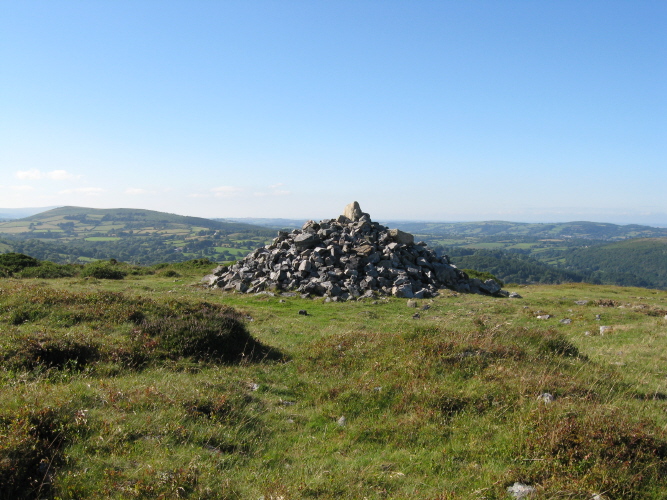
About 12 cairns lie within 400m of each other, most sited below the crest (the first three to the south separated by an aberrant reave, which fades away on the slopes of the ridge).
The four largest cairns (see plan to be posted) are 1-4, and are marked on the OS map. They are still an impressive sight, despite the regular remodelling of the stones by visitors. The edges appear partly intact and the similarity of the diameters (about 16.5m) suggests that this dimension is close to the original.
The above info was taken [but not exactly copied] from Butler's invaluable 'Dartmoor Atlas of Antiquities, Vol 1 - The East'.
He goes on to describe the other, smaller cairns there, which I've not copied on the plan.
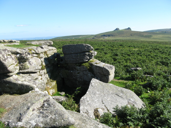
The visit, on a beautiful, sunny, breezy afternoon in July was very uplifting. Great views, including the sight of Trendlebere Stone Row in the valley below Cairn 4. Ample parking at SX771778, and following the marked footpaths on the OS map (Outdoor Leisure 28, Dartmoor), I took the one nearest the line of the first three boundary stones, then headed to the summit where [Butler's] Cairn 1 was visible.
Five of the cairns on Black Hill are scheduled as Historic England List ID 1004577.
The following cairns are featured on the Prehistoric Dartmoor Walks (PDW) website; see their entries for:
Black Hill 4 Cairn at SX 76281 78963 ("Cairn with modern stoneheap at north end. Diameter 17.0 meters, height 0.7 meters"). Also recorded as Pastscape Monument No. 444984.
Note: Join a cairn survey and repair party for a guided walk, Sat 28th July and on the same day a talk by archaeologist Jane Marchand about the discoveries at Tottiford Reservoir and White Horse Hill Cist
You may be viewing yesterday's version of this page. To see the most up to date information please register for a free account.







Do not use the above information on other web sites or publications without permission of the contributor.
Click here to see more info for this site
Log in or create a free account to see nearby ancient sites our visitors rate highly
All Nearby sites
 Click here to view sites on an interactive OS map
Download sites to:
KML (Google Earth)
GPX (GPS waypoints)
CSV (Garmin/Navman)
CSV (Excel)
To unlock full downloads you need to sign up as a Society Member. Otherwise downloads are limited to 50 sites.
Turn off the page maps and other distractions
Nearby sites listing. In the following links * = Image available
600m NE 43° Trendlebere Down Stone Row Cairn* Cairn (SX7662079230)
637m NE 40° Trendlebere Down* Multiple Stone Rows / Avenue (SX76627928)
776m SSE 147° Haytor Down Ring Cairn (SX76617814)
852m SW 225° Smallacombe Rocks Settlement* Ancient Village or Settlement (SX7558378211)
1.6km W 268° Hound Tor Deserted Medieval Village* Ancient Village or Settlement (SX74627878)
1.8km SW 226° Holwell Tor Settlement Ancient Village or Settlement (SX74887757)
1.9km W 274° Hound Tor Enclosure* Causewayed Enclosure (SX74307897)
2.1km W 268° Hound Tor Ring Cairn* Ring Cairn (SX7409778770)
2.7km NW 307° Bowerman's Nose* Rock Outcrop (SX74108046)
3.3km SW 218° Seven Lords' Lands* Stone Circle (SX74127623)
3.3km W 259° Chinkwell Tor Cairn* Cairn (SX7293078250)
3.4km NE 41° Datuidoc's Stone* Early Christian Sculptured Stone (SX7850081274)
3.4km SW 214° Stentifords Cross* Marker Stone (SX7424076030)
3.5km SW 227° Top Tor Cairns* Cairn (SX7357476472)
3.6km SSW 204° Rippon Tor* Cairn (SX74667558)
3.6km SW 227° Top Tor row Stone Row / Alignment (SX735764)
3.6km N 358° Hunter's Tor Fort* Hillfort (SX7616482412)
3.6km NNE 15° South Harton Cross* Ancient Cross (SX7724982273)
3.6km NE 40° Bishop's Stone (Lustleigh)* Ancient Cross (SX7860281532)
3.8km SW 218° Foales Arrishes* Ancient Village or Settlement (SX73777587)
4.0km NNE 21° Higher Combe Cross* Ancient Cross (SX7776482535)
4.2km SW 224° Tunhill Rocks* Ancient Village or Settlement (SX7318975796)
4.3km SW 219° Blackslade Down Cairn and Cist* Cist (SX7341275510)
4.5km NW 320° Easdon Hill Ring Cairn (SX73358231)
4.6km SW 217° Wittaburrow Cairn* Cairn (SX73347521)
View more nearby sites and additional images


 We would like to know more about this location. Please feel free to add a brief description and any relevant information in your own language.
 Wir möchten mehr über diese Stätte erfahren. Bitte zögern Sie nicht, eine kurze Beschreibung und relevante Informationen in Deutsch hinzuzufügen.
 Nous aimerions en savoir encore un peu sur les lieux. S'il vous plaît n'hesitez pas à ajouter une courte description et tous les renseignements pertinents dans votre propre langue.
 Quisieramos informarnos un poco más de las lugares. No dude en añadir una breve descripción y otros datos relevantes en su propio idioma.