

The Great Stone Circles – How they Work Part 8
Submitted by JACKME on Tuesday, 16 August 2005 Page Views: 3888
Alternative Archaeology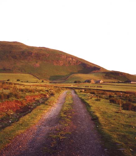
The location of Swinside
Last week I said I have only reported what I have seen. This week I am going to have to make deductions from those observations, which doubtless some of you will say are ‘nonsense’, or are things you know already. Good. That means you are thinking about things and not just accepting someone else’s theory. I am sure that a lot of what I am going to say will apply to most of the Great Circles, so why not go and have a look for yourselves. This week we return to Swinside for which I will not be providing a map as everything is centred upon the grid reference SD172882.For thousands of years the area around Swinside has held a magical attraction to man, with a series of circles near to the present stone circle, and over 30 pre-Roman manmade sites within a two mile radius, as well as many more at greater distances. These sites vary from a single standing stone, to other more complex groups laid out with great care. In addition to these there are countless burial sites, perhaps over 900 for the South Cumbria area as a whole, as was quoted to me some years ago. I am certainly not going to count them! They vary from large round cairns of varying types, down to what look like single grave mounds of stones, which I am told are of a similar date to the Swinside circle. These single grave mounds resemble those I saw in Korea, where ancestor worship was still very strong and they appeared to be placed so that the occupant could watch over the family home.
Why did the ancient people originally choose this area? No one really knows and we can only speculate and make deductions to help our guesses.
It is possible that there was originally a small henge built first. This was not placed on the top of Knott Hill (off the picture to the left) as one might expect, but some 900 metres to the south where the view was very much better and because, it seems, the ancients liked to hide their sites from the unwanted visitor. This early henge did not use a line through Knott Hill, but another line, which is now the track across the moor to Swinside, as seen in the top picture. This has at least two marker stones beside the track and points to the large carved rock on Wrayslack (as pictured here), which has a cut of over a metre deep made along its side for about 4 metres, and can only be seen when in line. It is best viewed when coming back from the circle along the track, or off the Main A595 opposite Hazel Mount drive at SD190869.Please note the rock is not on open access land.
In this next photograph we look down on the Swinside circle and see how the main track leading across the moor does not lead to the circle. The track past the gateway into the circle field points to the left of the trig point on Knott Hill, where there is a possible stone socket. The same position is suggested by several of the other lines that centre upon Knott Hill. The trig point there is concreted onto a rock outcrop away from the old point where this socket is. Obviously the Ordnance Survey would not have known about it, which is quite lucky because if they had used it, the socket would have destroyed.
We continue on across the Duddon estuary, to the henge called ‘The Kirk’ on Kirkby Fell as seen again in this photograph. The sighting of this henge is reason to suppose that there may originally have been another at the Swinside end of this line, particularly in light of the amount of work required to carve the rock on Wrayslack.
The idea that the ancients did not want everybody to find the site at an early time is further borne out by the North Stone (f) on Thwaites Fell which is positioned below the crest when viewed from the old track/road across the Fell. This route would have super ceded the original coastal track marked past Swinside circle, between the places where it is possible to cross the three estuaries.
In the earliest time a network of routes were laid out across the country. These seemed to go from natural marker to natural marker with manmade ones in between. Unfortunately these lines often passed through places which were difficult to walk with comfort, so man being man, they did not follow the lines exactly, but bypassed things like cliffs and very wet or very steep ground. Today it is fun to see why they moved off line. At Swinside several of these old tracks cross close to the circle, but none go through the present circle with the exception of the N/S line, which was not followed as a track in this area. They were following the age-old principle that you don’t build in the middle of the crossroads, but on the corner site, and they did exactly that.
People dowsing at Swinside often pick up lines of force in many places coming from the circle, these are however normally not old tracks, but force lines to the outstations marking the major sun and moon positions, which will be explained in a later article.
Another point of interest in this photo is the faint outline of a large circle in the right hand field (the one with the white cow in it). In Hutchinson Cumberland, published 1794, there is a description of another circle ‘being much dilapidated and to the south’. This is to the south of the farm steadings, not as many have assumed from the present circle. The stones from this large circle were used to build the farm barn in 1808.
All of the Great Circles are built close to the junction of these tracks for example Castlerigg, the Rollrights and Stonehenge . Later road builders have often followed these routes. There are two possible exceptions that I know of. The first being Avebury, where the roads goes through the middle of the henge, but avoid the smaller circles, and Brats Hill on Burnmoor in Cumbria, where the peat has buried any sign of a track system, and no one would want a road there today!
On the 28th November 2004 (near to the MMaSMNS) I watched the moon setting over Raven Crag above stone 49 from Stone 15 at Swinside (see Swinside diagram), and then kept moving, so that the moon was just touching the slope. As frequently happens the cloud blocked the view before it reached the bottom of the slope, but I know now that at this point I was actually close to another small circle, since seen as a cropmark on an aerial photo. On the ground the circle remains as a number of stones, which have been disturbed by field drainage operations.
There is also an observation place in the next field for watching the sun do the same thing, as was seen on 21st June 2004.
I suggest they may have given up this small circle because the ground would have been very wet before the modern drainage system was put in and with the increasing population a muddy mess would have been inevitable. Another consequence of the population growing was that they began to built much more impressive structures. The same thing appears to have happened at Burnmoor and Buttermere.
The next article will focus on the North/South line going through the circles in the western half of the county and some of their associated sites.
I will be away in Greenland looking at the Vikings, so there will be a pause for a month, when the next article will be on the North/South line going through the circles in the western half of the county and the pattern of some of their associated sites.
Contents page for the whole series is here
Note: This is the twelfth of a series of previously unpublished articles by retired farmer, Jack Morris-Eyton.


 We would like to know more about this location. Please feel free to add a brief description and any relevant information in your own language.
 Wir möchten mehr über diese Stätte erfahren. Bitte zögern Sie nicht, eine kurze Beschreibung und relevante Informationen in Deutsch hinzuzufügen.
 Nous aimerions en savoir encore un peu sur les lieux. S'il vous plaît n'hesitez pas à ajouter une courte description et tous les renseignements pertinents dans votre propre langue.
 Quisieramos informarnos un poco más de las lugares. No dude en añadir una breve descripción y otros datos relevantes en su propio idioma.