


<< Feature Articles >> Pleiades alignments in Wales? Archaoastronomy at Twmbarlwm and South Gwent
Submitted by Sivertsen on Thursday, 07 July 2011 Page Views: 6987
Iron Age and Later PrehistoryCountry: Wales County: Monmouthshire (Sir Fynwy) Type: HillfortInternal Links:


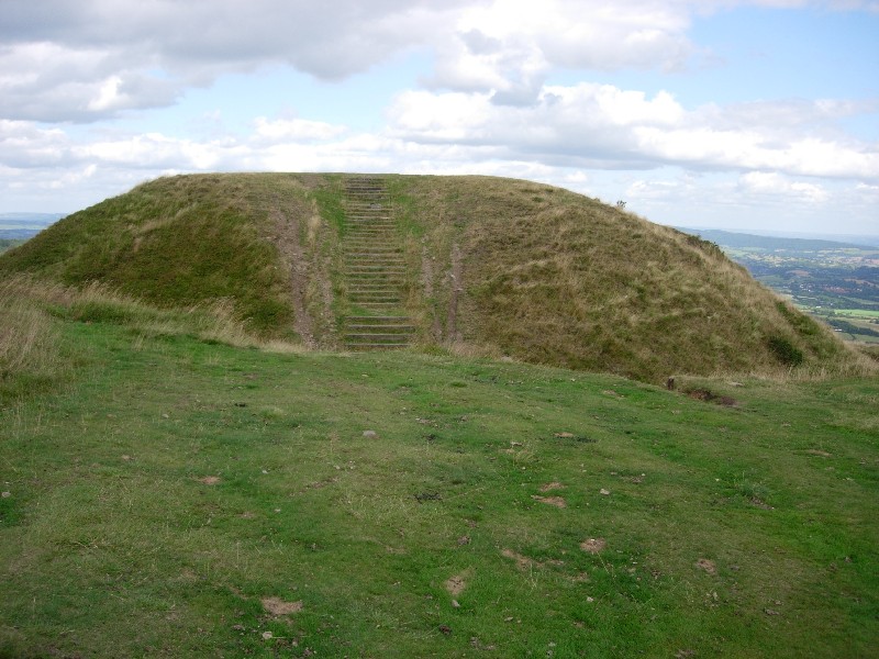
Twmbarlwm is highly visible. It is not the loftiest of the hills in this region but does have a prominence that others fail to display, a bulge. In fact the bulge should be regarded as Twmbarlwm as the hill is some 5 miles long with the far northern region [actually north, north east] being known as Mynydd Llwyd. The highest point Mynydd Twyn-glas is at 1550 feet and the more general central region - Mynydd Maen. Twmbarlwm, while better known due probably to its ‘pimple’ or Norman motte is effectively merely the southern peak at 1370 feet.
The upland region of Twmbarlwm is a flat area that has been surrounded by a ditch. It has therefore been classified as a hill fort, however I do not believe the shallow single ditch was ever deep enough nor wide enough to form any sort of realistic defence against an enemy. Even later Norman enhancements did not turn this into an effective barrier.
This ditch would originally have been the operative part of an animal enclosure meant to keep cattle within its boundaries. Bovine species are very poor at climbing out of ditches and hence a simple ditch is frequently sufficient to keep them in place. This is not dissimilar to the ‘ha ha’ ditch used to keep deer and other animals from grazing lawns around large country houses. The ditch was seemingly deepened a little by the Normans but even then it would not have been a very practical defensive measure.
The Norman motte is at the northern end of this flat area and intruded over the original ditch; and a new ditch section was dug at that end and around the motte as is normal practice. This ditch was deeper and wider than the original around the upland grazing area and was a typical Norman defence construction which the enclosure ditch of course was not.
Use has been made of this bulge on the hilltop, in effect the hilltop itself, since the early Bronze Age. Given findings of flint implements on the hills they were in use even before this era, although perhaps we should allow that flint was still used widely in the Bronze Age as not everyone had access to tools made from this new material.
I hope to show that this hill was used for astronomical sights and stones were erected in the lowlands below to facilitate this purpose. The hilltop was utilised to view the sunset 20 days after the vernal or spring equinox and 20 days before the autumn equinox. This was part of some highly accurate landscape setting out that was complete circa 2500BC with the date derived from the positions of the observed elements of the heavens, in this case the Pleiades.
This hilltop nonetheless has further connections to Bronze Age structures. Here the reference is to Gray Hill to the east of Newport and likewise Gray Hill has some additional apparent connections to Trellech some eight miles to the North.
Long before mining took place on the hillsides of Mynydd Maen, the bulge of the end of the range, Twmbarlwm, was utilised to fix times of year. It has very distinct and far reaching calendrical associations. The sighting effects here are over quite a distance, nearly 13 miles. What is seen is an association with the Pleiades in 2500BC., and with Gray Hill north of Magor in Wentwood, the steep hill overlooking the eastern side of Wentwood reservoir. While the Pleiades were observed by
numerous cultures in the northern hemisphere, what we see on the ground here in South Gwent appears to be unique.
During the Roman period over 2600 years later the then meaningless alignment to Twmbarlwm was again utilised by the Roman engineers who set out Venta Silurum, the Civitas built for the Silures, the local tribe of the area. We call this small town Caerwent.
Once more, between 600-700 years after the Romans left these shores, the Normans utilised the mound at the end of the hill range. In the intervening period between Bronze Age and that of the Normans, a small bank and ditch had been added to the raised area of Twmbarlwm. It seems that the Norman nobility took advantage of this and utilised it as the contained area of a bailey that was a part of the motte and bailey castle atop the hill - the motte being the ‘Twmp’ or ‘Pimple’. There was now a further sighting spot on the hill, the pimple - and this motte was indeed utilised in this manner - a visible assistant in the setting out of further mottes.
As is seen from these very brief notes this hill has been more than a little influential over the millennia with the carbuncle for which it is famed, the 1000 year old ‘Pimple’ or ‘Twmp’, the Norman ‘motte’, visible from as far as Somerset, being but the most recent of sighting points and as we shall reveal, this once more has far reaching consequences.
Let us next, however, transport ourselves back to the era circa 2500BC and reveal what can be discovered by anyone...without digging into the ground. All that is required at this stage to prove the argument to oneself is an OS map 1:25000 scale [most suitable combination of coverage and scale] and an astronomy computer program. Computerised mapping is a wonderful advantage but not essential. In fact much can be accomplished with the free Google Earth although one cannot backdate astronomical events with this program and the OS grid system, not available on Google Earth, is more favourable for this type of work than Latitude and Longitude as positions so denoted are transferable to a CAD program. The investigations seen here have been conducted via CAD with OS positions from computerised maps [Anquet 1:25000 series] transferred to the drawings.
At this point, to keep reading this article, please download the PDF version (4Mb download) as this has all the required diagrams and tables included.
Harry Sivertsen is the author of the books Measurements of the Gods and Deluge:From Genesis to Atlantis, which contain more of his research. These are available via the links to Completelynovel.com. The ebook versions are just £5.99 each and have rated 4/5 stars from readers there.
Read Parts 2 and 3 of this article here
<< The Prehistoric Nidderdale Project
Pleiades alignments in Wales? Archaoastronomy at Twmbarlwm Parts 2 and 3 >>


 We would like to know more about this location. Please feel free to add a brief description and any relevant information in your own language.
 Wir möchten mehr über diese Stätte erfahren. Bitte zögern Sie nicht, eine kurze Beschreibung und relevante Informationen in Deutsch hinzuzufügen.
 Nous aimerions en savoir encore un peu sur les lieux. S'il vous plaît n'hesitez pas à ajouter une courte description et tous les renseignements pertinents dans votre propre langue.
 Quisieramos informarnos un poco más de las lugares. No dude en añadir una breve descripción y otros datos relevantes en su propio idioma.