

Jerimalai
Submitted by bat400 on Tuesday, 26 June 2012 Page Views: 20597
Natural PlacesSite Name: JerimalaiCountry: Indonesia
NOTE: This site is 350.495 km away from the location you searched for.
Type: Cave or Rock Shelter
Nearest Village: Tutuala
Latitude: 8.4S Longitude: 127.250000E
Condition:
| 5 | Perfect |
| 4 | Almost Perfect |
| 3 | Reasonable but with some damage |
| 2 | Ruined but still recognisable as an ancient site |
| 1 | Pretty much destroyed, possibly visible as crop marks |
| 0 | No data. |
| -1 | Completely destroyed |
| 5 | Superb |
| 4 | Good |
| 3 | Ordinary |
| 2 | Not Good |
| 1 | Awful |
| 0 | No data. |
| 5 | Can be driven to, probably with disabled access |
| 4 | Short walk on a footpath |
| 3 | Requiring a bit more of a walk |
| 2 | A long walk |
| 1 | In the middle of nowhere, a nightmare to find |
| 0 | No data. |
| 5 | co-ordinates taken by GPS or official recorded co-ordinates |
| 4 | co-ordinates scaled from a detailed map |
| 3 | co-ordinates scaled from a bad map |
| 2 | co-ordinates of the nearest village |
| 1 | co-ordinates of the nearest town |
| 0 | no data |
Be the first person to rate this site - see the 'Contribute!' box in the right hand menu.
Internal Links:


External Links:


I have visited· I would like to visit
bat400 would like to visit
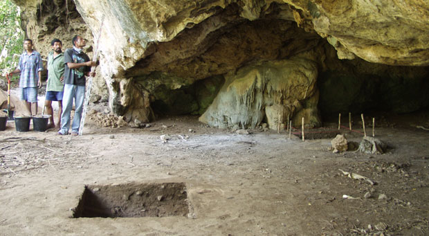
These finds may indicate the specific route of modern humans who pioneered the the route to Austrailia. Approximately 50000 years ago, low ocean levels created a continental shelf, Sunda, creating a contiguous land mass where southeast Asia now lies. But Sahul, the contenental extension of the current Austrailia and New Guinea did not connect to Sunda, so the modern humans were still forced to island hop as they moved farther south. East Timor was one of the Sunda islands.
The people who lived at Jerimalei ate turtles, tuna, and giant rats. Their stone tools, fishhooks, worked shells remain.
Note: The location given is for the general area and does not reflect the specific location of the rock shelter.
Sources:
Sue O'Connor (Australian National University), "New evidence from East Timor contributes to our understanding of earliest modern human colonisation east of the Sunda Shelf", Antiquity, Volume: 81 Number: 313 and "Long-term obsidian use at the Jerimalai rock shelter in East Timor", Archaeology in Oceania, vol. 46, no. 2.
Deborah Smith, "Timor cave may reveal how humans reached Australia" , and "Cave find a stepping stone back to early man".
Note: World’s Oldest Deep-Sea Fishermen, see comment.
You may be viewing yesterday's version of this page. To see the most up to date information please register for a free account.
Do not use the above information on other web sites or publications without permission of the contributor.
Nearby Images from Flickr
The above images may not be of the site on this page, but were taken nearby. They are loaded from Flickr so please click on them for image credits.
Click here to see more info for this site
All Nearby sites
Download sites to:
KML (Google Earth)
GPX (GPS waypoints)
CSV (Garmin/Navman)
CSV (Excel)
To unlock full downloads you need to sign up as a Society Member. Otherwise downloads are limited to 50 sites.
Turn off the page maps and other distractions
Nearby sites listing. In the following links * = Image available
637.7km NW 307° Liang Metanduno Cave* Rock Art
639.1km NW 307° Liang Kobori Cave or Rock Shelter
654.5km S 186° Kalumburu Cave or Rock Shelter
690.7km W 265° Bena Village Megaliths* Ancient Village or Settlement
748.8km W 268° Liang Bua Cave Cave or Rock Shelter
753.5km WSW 258° Rindi Umalulu Burial Chamber or Dolmen
753.6km S 184° Drysdale River National Park Rock Art
766.2km SE 133° Kakadu* Rock Art
767.1km SE 126° Kakadu - Ubirr* Rock Art
769.9km SE 127° Kakadu - Madjedbebe* Cave or Rock Shelter
833.2km ESE 121° Nawarla Gabarnmung rock art site Rock Art
853.3km W 261° Anakalang Burial Chamber or Dolmen
869.7km W 260° Waikabubak East Burial Chamber or Dolmen
872.1km W 260° Waikabubak Burial Chamber or Dolmen
897.0km NE 56° Bitsyari Bay, West Papua* Rock Art
918.8km WNW 294° Leang Pettakere* Cave or Rock Shelter
918.8km WNW 294° Leang Karampuang* Rock Art
918.9km WNW 294° Leang Pettae* Cave or Rock Shelter
924.8km WNW 294° Bulu Sumi Cave* Cave or Rock Shelter
925.0km WNW 294° Leang Sumpang Bita* Cave or Rock Shelter
1009.7km NW 306° Londa Tana Toraja* Rock Cut Tomb
1010.1km NW 306° Ke´te Kesu´ Standing Stones* Stone Circle
1014.2km NW 307° Batu-Batu Standing Stones Standing Stones
1014.2km NW 307° Bori Kalimbuang* Stone Circle
1033.1km NW 305° Pali Standing Stones* Standing Stones
View more nearby sites and additional images


 We would like to know more about this location. Please feel free to add a brief description and any relevant information in your own language.
 Wir möchten mehr über diese Stätte erfahren. Bitte zögern Sie nicht, eine kurze Beschreibung und relevante Informationen in Deutsch hinzuzufügen.
 Nous aimerions en savoir encore un peu sur les lieux. S'il vous plaît n'hesitez pas à ajouter une courte description et tous les renseignements pertinents dans votre propre langue.
 Quisieramos informarnos un poco más de las lugares. No dude en añadir una breve descripción y otros datos relevantes en su propio idioma.