


Abandoned Landscapes - Introduction
Submitted by M_M_Robinson on Monday, 13 November 2006 Page Views: 3222
Multi-periodCountry: Wales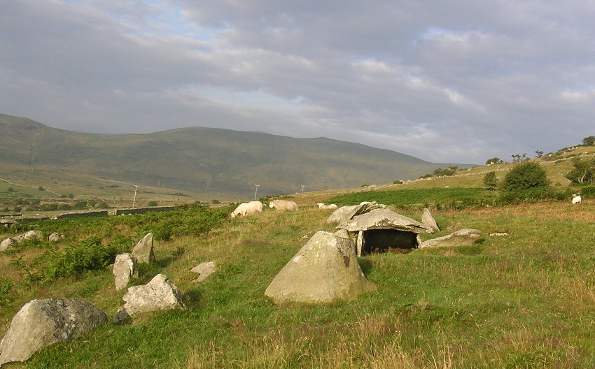
For the present the tide of human colonisation has largely receded from the hills and mountains of North Wales, leaving us as archaeological beachcombers on one of the richest archaeological strands in Europe. I write this journal as an exploration and celebration of this place and of the people who made their lives here in the past.
It is something of an experiment in that the descriptive journeys which form its core are a deliberate attempt to recapture the narrative immediacy and diligent enthusiasm of the journals of the early topographic and antiquarian writers, albeit within the context of modern archaeological research.
Even in such an apparently undeveloped region, the physical landscape has become fragmented by engineered roads, power lines, reservoirs, forests and the like. Nevertheless, unlike much of lowland Britain, we can still see with some clarity the template of the historic landscape and the mosaic of micro-environments from which it is composed [note 1]. What are the defining historical patterns and currents which emerge from a study of these hills? The following is a rapid review of this question:
'Personality’- Mountains and People
The perception of Snowdonia as a place of natural beauty was formalised with its designation as a national park in the 20th century, but its special status was already apparent in Romantic art and literature over 200 years ago, but this area forms only one element of a complex and diverse region. A fascinating and highly relevant pre-modern thumbnail sketch of the landscape is provided by Giraldus Cambrensis. Writing in the late 12th century, he emphasised the role of the estuaries and rivers (naming the Dyfi, Dysynni, Mawddach, Artro, Conwy, Clwyd and Dee), and identified the 'snowy mountains of Eryri' as the ultimate source of these watercourses (Giraldus N.D., 162-3). He also referred approvingly to an 'ancient proverb' which counterpoints the productive arable terrain of Anglesey against the huge tracts of grazing in the uplands:
'As Mona could supply corn for all the inhabitants of Wales, so could the Eryri mountains afford sufficient pasture for all the herds, if collected together.' (ibid 127).
The identity of these contrasting ecological zones is brought more sharply into focus by the proximity of each to the other, and a cultural and economic symbiosis is likely to have existed between them since the Neolithic.
Historically, people of the European uplands tended to be characterised as 'tough, hardy, resilient...adventurous, full of initiative', and were frequently seen as warlike (Pollard 1997, 264-5). Such qualities may have had a basis in fact; a high degree of self-sufficiency and self-reliance would be needed to survive in the often harsh and complex upland environment, and as state societies developed, such independence of spirit would be difficult to stamp out in areas remote from centralised control.
Social Conflict and Warfare
Whilst we should be careful of generalisations, it is true that probably from the Late Iron Age at least, the highlands of Wales represented a physical and symbolic redoubt for tribes and emerging kingdoms. It was at one of the peripheral hillforts that the last resistance to the Roman invasion reached its bloody conclusion; the chronicles of the Early Medieval period are dominated by internal warfare amongst the ruling dynasties, and in the later Medieval period there was chronic strife between the indigenous population and Norman/English state (with a final resurgence in the Glyndwr revolt of the early 15th century). [note 2]
In addition to warfare and raiding there will always have been conflicts and social stresses, especially at local level, in relation to competition for resources, especially pasture. Evans writes: 'The grazing rights on the hills were a source of bitterness in many a Welsh valley. Farmers struggled with one another for a few acres and family feuds that lasted for generations were the result.' (Evans 1948 74). In modern times there was also considerable class-based conflict, for example between small farmers and the large landowners (Evans 1948 24ff, and 73ff; Howell 2000), and between the workers in the mines and quarries and their owners (Perrin 1997).
Whilst to some extent the theme of warfare and conflict can be traced through archaeological evidence such as weapons, hillforts, castles, and more indirectly by abandoned smallholdings, mountain intake walls etc., it doesn't form a major element of this study.
'Marginality'
Upland regions are traditionally viewed as economically and culturally marginal or peripheral to the more densely populated and wealthier lowlands, especially in relation to towns and cities (Pollard 1997 260). Although North Wales has a significant industrialised and urbanised zone on the lowland and upland fringes, it is commonly thought of as such a marginal area - distant from centres of power and economically depressed both in recent and earlier times - but perhaps this issue is not quite as clear cut as may first appear.
Firstly, upland territories were important productive units throughout history, as Winchester explains: 'Far from being empty spaces between settled landscapes of farms and fields, as they have sometimes been viewed, the hills of upland Britain were a valuable and indispensable resource for local communities, yielding extensive grazing reserves, fuel...thatching materials and a variety of other products.' (Winchester 2000, 1), and intensive field survey in the Welsh hills during the last decade or so has revealed a staggering quantity of previously unknown sites, especially of the Medieval and Post-Medieval periods.
Secondly, for most of prehistory (until probably the Late Iron Age when larger-scale polities developed) the concept of marginal regions or territories was irrelevant (or at least subjective) because there was no real centre or heartland in Britain or even Western Europe [note 3].
Thirdly, we need to remember that North Wales as a whole was frequently in the historical mainstream. Specific developments and initiatives of great significance include the largest known Bronze Age copper mines in Europe at the Great Orme, the cordon of Edwardian castles which represent some of the greatest Medieval fortifications in the world, and more recently it was 'the location of some of the key developments of the early stages of the British Industrial Revolution' (most notably the development of innovative techniques of cast iron production in the 18th century at Bersham) (Pollard 1997, 212; Grenter and Williams 1991 219). More generally, from the Post-Medieval period the people of the region embraced the market economy through cattle and wool production. There were several progressive agriculturists in the 18th and 19th century who drained marshes and 'improved' the hill land. In the same period, some of the world's largest mineral and rock extraction sites developed in or around the uplands, supplying raw materials (e.g. slate, copper, lead, coal, water) to feed the adjacent heartlands of the industrial revolution in the Midlands and the North West. (Pollard 1997, 212).
Therefore, applying the blanket term 'marginal' to the region is unhelpful in understanding its complex and frequently dynamic settlement history [note 4].
Environmental Constraints
Notwithstanding the above, it must be admitted that husbandry in the upland landscape has been profoundly affected by environmental constraints. The repertoire of responses to issues such as altitude, weather and soil quality is limited and has led to embedded patterns or 'deep structures' in the archaeological landscape.
The most obvious is that stock raising (mainly cattle and sheep, plus goats and horses) has predominated over arable cultivation. I will argue below that this has been based on the movement of people and animals from lowland to upland either seasonally or daily, and that this practice is the defining characteristic of life in the mountain areas from later prehistory to the 18th century (see Ward 1997 for a review of this issue).
Interestingly, within this broad pattern, whatever stock husbandry regime has been in operation, the different environmental zones or catchments have frequently been put to similar use at different periods. Furthermore, within the upland settlement pattern, we see the repeated reuse of the same favoured locations for seasonal dwellings, stock shelters or other structures, sometimes over thousands of years. Encroachment of permanent settlement into the hills is also a recurring feature, mediated by climatic conditions and population stress. The Bronze Age and the 18th/19th century are typically cited in this context.
Nowadays it is easy to forget how tough life must have been for those living here in pre-modern times. The weather was unpredictable, the environment uncompromising, and society more lawless and unstable. One or two wet seasons, social conflict, or disease or illness in the community or amongst the stock, would bring localised starvation and worse. During times when population levels allowed sustainable transhumance to operate existence may have been no worse than in wealthier lowland areas. However, for those forced through periodic economic or population pressure to clear and cultivate the uplands, subsistence and therefore life itself must have been on a continual knife-edge, often ending in heart-breaking failure. (See for example Thomas 1989 257; Howell 2000; Bil 1990 39).
Connectivity and Communication
As has been implied above, the present remoteness and emptiness of the uplands is an historical novelty. Until relatively recently wide-ranging contacts, travel and exchange into and across these hills has been an intrinsic trait. Mountain communication networks are like those on water or in wetlands - daunting to the uninitiated or the outsider but eminently practical if undertaken with local knowledge, experience and resources.
Horden and Purcell emphasise this contrast between outsider perspectives and the reality of familiar usage:
'Mountains can seem hostile and marginal areas: yet they are actually closely integrated into the patterns of production and communication that abut them. That explains why mountain zones unexpectedly - and even paradoxically - become regions with wide internal coherence and close contact and interchange across what appear, to the outsider, to be formidable physical obstacles.' (Horden and Purcell 2000, 81 and see also 124).
When considering the prehistoric period (and probably more recent times to a lesser degree) we must put aside the conventionally surveyed and orientated map of Britain, and instead seek to construct alternative cognitive geographies. At the grand scale, our area was part of the Irish Sea region, itself a element of the Atlantic region, stretching along the coasts of Western Britain and Ireland, Brittany and western Iberia (Cunliffe 2001 passim). Many of these far-flung places were probably more accessible and familiar to the local population than what is now called southern England or even South Wales. The same applies at the regional and local level - our mental map is dominated by the modern trunk-road communication pattern which obscures 'traditional' networks based on coast-hopping, the estuaries, rivers and natural land routes.
In retrospect I feel that the journal has achieved merely a surface description - of contours, topography and time-weave. Only occasionally have I managed to peer under the skin of long-term historical change to glimpse its deeper muscular contractions and its environmental and human pulses, flows and actions [note 5]. Perhaps a bigger frame including the adjacent lowlands, the Llyn peninsula, Anglesey and the great spaces of Central Wales would have helped by illuminating both contrasts and inter-dependencies. My biggest regret is that I hardly entered the knowledge domains of local and oral history, place names, folklore, and direct experience of 'traditional' husbandry - all aspects so poetically synthesised by Tim Robinson in his magisterial study of Aran on the West coast of Ireland (Robinson 1990, 1995). 'But' as Robinson himself says, 'for a book to stand like an island out of the sea of the unwritten it must acknowledge its own bounds, and turn inward from them, and look into the labyrinth' (1990, 382).
Note 1: The search for pattern and meaning in archaeological landscapes is a long and powerful tradition (see for example Stoddart 2000a, Tilley 1994 24-6 and Thomas 2001 for reviews of this field of study). Waterbolk 1995 offers us a concise definition of 'landscape' as the 'ordered structures man has imposed on his natural environment' .
Looking firstly at the concept of the 'natural environment', in fact this is an ever-moving target always altering its character. This can be through natural agency (e.g. climatic shifts) or as a result of human action (e.g. forest clearance leading to soil degradation). Thus even in the remote uplands the 'natural environment' is a rare commodity; virtually all the components of the upland environment - peat formation, vegetation, drainage, flora, domesticated and wild animals and birds - have been continually altered through human activity and exploitation.
Turning now to the idea of 'ordered structures', this incorporates the traditional concerns of landscape archaeologists such as settlement pattern and economy. But equally legitimately it should relate to cognitive structures. This is an important strand in recent 'phenomenological' thinking in which landscape is perceived as a cultural construct formed by tradition and memory, as a potential map of a societies' vision which can be investigated by looking at the relationship between and within sites, monuments, and the broader landscape (Bruck and Goodman 1999 passim, Evans 1985). This also resonates with current ideas relating to the study of landscapes through 'deep mapping' and the use of indeterminate or flat chronologies (Shanks 2001 299-300; Tilley 1994 74.)]
Note 2: For the site of the last stand of Caratacus see Jones 1991, for general Medieval conflict see Davies 1993, 100-01, and for Glyndwr revolt see Davies 1997.
Note 3 : Graves-Brown (2002) points out that the concept of Wales didn't exist in prehistory and the present economic and political marginality of the Principality in relation to the British state shouldn't colour our thinking about earlier times.
Note 4: This is not to deny that the term is useful in connection with specific issues such as permanent settlement or arable cultivation.
Note 5: see Barker 1995 for a regional study where this has been systematically and successfully tackled.
See here for contents page, or here for the bibliography.
Note: This is part of an original series of articles written by archaeologist M M Robinson.


 We would like to know more about this location. Please feel free to add a brief description and any relevant information in your own language.
 Wir möchten mehr über diese Stätte erfahren. Bitte zögern Sie nicht, eine kurze Beschreibung und relevante Informationen in Deutsch hinzuzufügen.
 Nous aimerions en savoir encore un peu sur les lieux. S'il vous plaît n'hesitez pas à ajouter une courte description et tous les renseignements pertinents dans votre propre langue.
 Quisieramos informarnos un poco más de las lugares. No dude en añadir una breve descripción y otros datos relevantes en su propio idioma.