

Abandoned Landscapes - Bangor to the Severn - (Carneddau, Denbigh Moors, Berwyn)
Submitted by TimPrevett on Friday, 24 November 2006 Page Views: 29020
Multi-periodCountry: Wales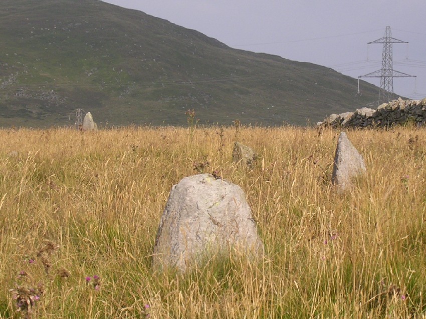
An ancient routeway from Anglesey to the Severn Valley, linking the fertile and well-populated island with the English midlands and beyond, has been suggested by more than one authority (Bowen and Gresham 1967; Watson 1965, 49-50 and Frontispiece map).
This chapter recounts my attempt to follow this route, over hill, pass and valley, on bleak moorland tracks and along modern roads, across the rivers Conwy, Alwen, Dee, and Ceiriog before reaching the border lowland near Oswestry. En route I encountered stretches of ancient worn track, undated stock ways, formal drove roads, packhorse roads, and many archaeological sites.
I remain open-minded about its reality as a significant long-distance prehistoric route, and there is no denying that there are long gaps for which there is little evidence where Taylor's 'zones of movement' concept must be brought into the argument (Taylor 1994, 2-3) [note 1]. Nevertheless it follows real trackways for a good deal of the way and there is much of archaeological interest.
Medieval Bangor and Neolithic Llandegai
Middle-aged ladies in overalls were putting out flowers and sweeping the aisles of the little cathedral in the centre of Bangor when I pushed open the heavy wooden door and peered inside. I sat in a pew for a few moments contemplation, feeling like a pilgrim about to set out on a sacred journey, and then started on my way. I thought it apt to begin from this true town of Wales; not an English plantation like many others but one which grew up around the cathedral in the 12th century with its origins in the 6th century when the monastery of St. Deniol was founded here (Soulsby 1983 76-7).
The first stage of the journey was to be along the Medieval route between Bangor and the village of Llandegai only a mile to the south east, passing by the site of the Llandegai henge monuments. It took less than 5 minutes to walk from the Cathedral along the main street and then steeply up Bishop's Mill road to reach the track where it entered fields and woods on the shoulder of Bangor Mountain. How satisfying and evocative it was to move so rapidly from the heart of the town into countryside, an experience which must have been so familiar to town dwellers in the pre-modern period. The 'mountain' is no more than a small hill, and on the far side the track dissipates into a housing estate but then miraculously reappears, banked on both sides as it dives into dingy, scrubby woodland on the fringes of Llandegai industrial estate. Incongruously, this god-forsaken place with its industrial sheds and high steel fencing once had a powerful religious presence, being the site of a large Late Neolithic ceremonial centre which would not have been out of place on the Wessex Downs.
This complex multi-period site on a flattish plateau on the fringe of the mountain zone was discovered through aerial photography and excavated in the late 1960's before the industrial estate was built on it. There were two Late Neolithic henge’s (a circular ditched enclosure with the bank on the outside, thought to have had communal ceremonial functions), 70-80m in diameter, probably in successive use. The earlier of the two (henge A.) produced a Langdale stone axe placed blade down and an axe-polisher of Pembrokeshire stone, both of which had been ritually deposited. Many cremation burials were found in association with the henges as well as some pits containing distinctive pebbles, whilst the later henge (henge B.) also produced beaker pottery. Connected with this important and long-term ritual usage was a cursus (a pair of parallel banks usually interpreted as processional ways), the terminal of which was located between the henges and its alignment continuing at least 200m to the east where it disappears under Llandegai village.
Rubbish pits associated with a large rectangular building beneath henge B. (and thought to be broadly contemporary with the henge A.) produced fragments of Graig Lwyd axes. Pollen evidence suggested grassland with an absence of cereal pollen in the vicinity, consistent with a pastoral regime. The attractiveness of the terrain for occupation is further indicated by the discovery of a large Iron Age round house and other occupation evidence inside the earlier henge. The final twist in the tale of this site was the discovery of a Medieval cemetery, possibly associated with a now-lost church or chapel, across the cursus alignment. Running between the henges and alongside the cursus was a double-ditched road (abandoned in the early 19th century as a result of the construction of the turnpike through what is now Penrhyn Park), probably the continuation of the Medieval track I had been following (Houlder 1968).
Why was such a religiously significant prehistoric site located here? The excavator described it as 'a natural meeting place of land and sea routes', and he associated the early usage of the site with axe-trading (Houlder 1968, 219). Indeed it can be argued that it formed a geographic nexus between Anglesey, the western coastland, the Ogwen valley (where the Neolithic tomb of Bryn Eglwys is sited three miles to the south), and the high-level routes across the hills to the Conwy valley. Such major religious sites were also usually set in environments favourable for settlement and it is clear that this was the case here. It may be too simplistic to suggest that this was the symbolic start of the routeways across the Carneddau (see this and previous chapter), but it must have been a place well-known, if only by repute, to the network of communities connected by these trails.
Along the ancient track from Aber over Bwlch y Ddeufaen
To reach the routes over the northern Carneddau we first have to cross several miles of broad coastal belt, a zone too wide and flat to have developed a visible track. I followed the minor country roads, mainly pleasant lanes banked high with hedges burgeoning with nettle, briar, foxglove and dog rose. Aber, which stands at the mouth of the Anafon valley guarded by a Medieval motte and overlooked by a hillfort, is the gateway to our route over Bwlch y Ddeufaen (it is a further three miles east along the coast to Llanfairfechan and the Druid's circle track way described in the previous chapter). The steep little road up the valley delivers you to the very edge of the moors and the start of the best-known ancient routeway in North Wales. As so often the weather broke as I approached the high ground and I sat on a wet rock at the road head and ate a miserable lunch, sheltered from the swirling drizzle by my umbrella.
Of all the routeways in North Wales this bears the clearest evidence of long-term usage - deep holloways, prehistoric cairns and standing stones, traces of a Roman road, and later settlements [note 2]. It is the toughness of the terrain combined with a measure of luck which has protected this section from destruction. A turnpike was proposed along the route in 1777, and again it was threatened in the 1960's when it was one of the options for a main route bypassing Conwy. The solution eventually chosen was an immersed tube-tunnel under the estuary which during its construction in the 1980's was the second biggest engineering project in Europe (the largest being the channel tunnel). Unfortunately our route hasn't survived entirely unscathed due to the attraction of its natural line and it now carries 2 power lines and a gas main (Senior 1991, 8-9, 51-2, 76-81, 96-107).
The initial stretch, up and across the shoulder of Foel Dduarth onto the sea-facing slopes of the Carneddau, has been well-known for 200 years and more for its concentration of ancient sites (Bezant Lowe 1912; Pennant 1883; Fenton 1917, 181; and the Colt Hoare Journal in Thompson 1983, 256-7). A myriad of old tracks and holloways thread their way through rough stony ground grass and gorse. One way passes right beside an impressive prehistoric settlement of hut circles within an oval enclosure cut into the slope (site 1, 677716). Nearby are the remains of a Medieval rectangular building although it is difficult to identify (Bezant Lowe 1912, 110-1). Higher up, almost lost in thick gorse and heather is the famous ring cairn of Carnedd y Saeson, visible as two rings of large stones, the outer ring measuring 8-9m across. Two big stone slabs and a hollow in the centre represent a disturbed burial cist (site 2, 678 717, Lynch 1995, 44; RCHMW 1956, 17). Its viewshed is primarily towards Aber. Around here are remains from several periods; more holloways, further cairns, both Bronze Age and Medieval, and stretches of relict, overgrown walling (Lynch 1995, 44, 91-2).
Once around the shoulder of Foel Dduarth, the route is able to follow a more steady course, contouring the gentle sea-facing slope, providing fine views of the Conwy Bay and Puffin Island. The ground here is unimproved, with many large stones, patches of bog and yellow gorse where sheep and wild ponies tug at the rough damp turf in the quietude.
The main track in use nowadays (possibly following the Roman course) is only one of several; at other times the slightly steeper ground above seems to have been favoured, signified by parallel worn furrows, here and there edged with stones, and the presence of adjoining sites. The largest of these is a prehistoric stone-banked enclosure, now partially occupied by a large disused sheep fold, formerly known as Buarth-Merched-Mafon (the sheep-pen of Mafon's daughters) (site 3, Photo 25). Set on a relatively flat area of turf, partly cleared of stones, it displays a couple of scooped areas just outside the fold which were probably structures. About 100m away is a low earth bank running up the hillside which may have been an associated boundary. It is reminiscent of the enclosures in some of the Carneddau cwms and also some I’ve seen to the north of Little Rough Tor on Bodmin Moor. Like these it was perhaps associated with seasonal cattle-folding. Climbing the slope above to find the best view for a photograph I ended up at the same place as H. Foyn who photographed it 90 years ago (Bezant Lowe 1912, 113). Whilst the enclosure looks unchanged, the sheepfold which was in full repair prior to 1912 has suffered badly from collapse and damage (680717) (Bezant Lowe 1912, 107-12; RCHMW 1956, 6).
Near the modern track is the site of an incised stone, probably associated with the prehistoric use of the routeway, but on this rock-strewn terrain locating it is like the bouldery equivalent of looking for a needle in a haystack (Bezant Lowe 1912, 167). After half an hour of fruitless hunting I gave up and concentrated on finding easier targets such as the many cairns along the route, a prehistoric homestead (consisting of 2 hut circles with an enclosing wall), and a little further upslope two unusually small boulder-shelters with associated walls (sites 4 and 5, vicinity of 683719).
A mile and a half before the main bwlch the route has to cross Garreg Fawr, the little toe of the long ridge of Drum. There is a meeting of ways on the top, with a track leading north down to the coast at Llanfairfechan. This is a fine belvedere, particularly towards Three Rivers, the Dinas outcrop and the start of the Druid's Circle trackway. Significantly there are two incised stones at this point, one of which I triumphantly located near the base of an electricity pylon. Another such stone, apparently the most elaborate of the group, is sited on the lower ground half a mile further towards Three Rivers but I haven't been able to find it to confirm this. (Bezant Lowe 1912, 167-8) [note 3].
As it climbs more steeply towards the pass, the modern way is accompanied by braids of much older man-deep V-shaped paths, swamped in the heather, sometimes four or five abreast, forming the most impressive section of early holloways in the region (Photo 26).
Part-way along on the uphill side of the tracks is a bilberry covered marker-cairn with its stony middle dug out (709720). It was raining hard as I approached the top, where I met half a dozen women horse-riders negotiating the gate across the pass, sheathed in glistening, dripping waxed-jackets. We agreed the rain was set in for the day and I stood aside and waited for them to file past, disconcerted by their closeness in this wilderness and the hot pungent smell of the steaming horses.
Standing on the wooden ladder stile beside the gate at this high point I was at the threshold of a new domain; the rock-strewn slopes of Tal y Fan close up on the left, more distant hills on the right, and ahead, contouring around Tal y Fan, the ancient track leading through the thin upland pasture down to the misty green of the Conwy valley and the lead-sheened estuary four miles away. This is a land of striking texture and colour, rich in prehistoric sites. A burial cairn is sited below the pass to the right of the various worn pathways, whilst further down two large standing stones soon come into view. The taller one is about 10ft high, whilst the other one, some way beyond, stands to about 6ft (716718) [note 4].
Approaching them from above like this, their visual impact is not strong. However, climbing up the pass from the Conwy valley, their physical presence is much more impressive as they loom above you like sentinels at a border. Thus I believe they were primarily intended to signify the leaving of this territory rather than to mark its border for those entering. I am reminded of passing through the outskirts of Protestant villages in Northern Ireland a few years ago where the hanging flags and the red white and blue-painted kerbstones and lampposts proclaimed their British identity as much to themselves as to outsiders.
The rough track soon reaches the road head with a small car park, and for a stretch the ancient route has a skin of tarmac with high drystone walls on either side. Here, for the first time the line of the Roman road clearly emerges, contouring the lane a few yards up the slope on the left. Because of the ease of access this stretch is more populous, and I passed a small party of walkers and a young couple with backpacks making their way up to the pass.
A little further on and some stepping stones in the wall on the right led me to an unusually level and clear grassy area about the size of a bowling green where I gradually traced out the shape of the prehistoric circle of Cerrig Pryfaid; only about 20m across and made of very small upright stones, some thin and triangular with a couple of outliers and a suggestion of a central cist (724713, RCHMW 1956 37, site 177). In comparison to the monoliths at the bwlch the stones appear so small and fragile, and that they have remained recognisable for sixty generations or so is remarkable. As with many circles it is in a prescient location, with wide views outwards (south east across the Conwy valley), but itself merging into the landscape from any distance. Although not apparent from the circle itself, it sits atop a rough and jagged small outcrop which has tumbled massive boulders into the now-barren and very marshy Tafolog valley. This may be another example of a 'stone waterfall' (see Darvill and Wainwright 2002).
Near the smallholding of Cae Coch there is an ancient junction of ways. To the left (north) is a path over Tal y Fan, and a minor path heads north east to Caer Bach hillfort [note 5]. Straight ahead is the direct route down to the Conwy valley at Roewen, whilst to the right is a diverging road which we will follow south east, diagonally across to the far side of the Tafolog valley past the major hillfort of Pen y Gaer at its mouth to gain the upper reaches of the Conwy valley (site 18) [note 6].
A landrover pulling a sheep trailer chugged past me and pulled up at Cae Coch. The tarmac rolled on through a forsaken landscape of rough wet pasture and old field walls and enclosures, gradually descending until the wide ribbon of the Conwy estuary came into view and manicured cottage gardens on the outskirts of Llanbedr materialised through the thick mizzle. I stopped under some trees to look at the map and as I stood immobile a sorry-looking bedraggled hare lolloped down the road past my feet, sat close by for a few seconds oblivious to my presence, pondering its own itinerary. Then remembering something forgotten, it turned round and hopped past me up the road again.
Meandering up the Conwy Valley to Llanrwst and Nebo
The hill road drops down to the edge of the flood plain to join the road from Conwy at the village of Tal y Bont. Taking the opportunity of a respite from the rain I commandeered the stone bus shelter, took of my boots and socks and put my weary feet up on the bench. Almost immediately an elderly woman arrived hoping to catch the bus to Conwy where she lived. Looking at my boots and scattered kit, she wistfully confided that 'I used to walk in the hills but I'm too old now'.
Tal y Cafn, two miles downstream was the main crossing of the river but for those heading inland up the valley as I was, the traditional fording point is at Llanrwst, four miles to the south. Nowadays its difficult to avoid road walking this stretch so I fortified myself with a mutant five-fingered kit-kat and a custard pie from the post office and this gave me energy to reach Dolgarrog, home to a large aluminium works. Beside the road is a memorial to the people who died in the disaster on the 2nd November 1925 when the dam high in Cwm Eigiau, built to provide hydro-electricity to the aluminium works, burst its fabric. The huge boulders carried down by the force of the flood still lie on the verges of the road, and great black water pipes, falling steeply like alien tree-roots from the wooded hills, still bring water from the mountains to the works. One of the string of Neolithic tombs along the Conwy valley corridor is located close to the stream nearby but I failed to find it (site 19, 770677).
The old route is assumed to have kept to this side of the river until Llanrwst, but rather than road-slog any further, I decided to cross the river early via a footbridge. This would provide an opportunity to explore a small hillfort near Maenan on the steep east side of the valley in the woods of Coed Tan yr Allt, and to judge if it was sited here to guard a 'lost' river crossing, possibly related to the ancient route. The footbridge, reached along a miserable deserted industrial roadway, proved to be quite a substantial disused steel railway bridge, now carrying two huge pipes with a timber footway between.
Despite this depressing approach the river was a pleasure to meet. Downstream it flowed softly through empty wet green meadows, whilst upstream it emerged from the evening mist and the hills, straddled by a most intense rainbow, one foot dipping in the water and the other shimmering over the wooded slopes on the far side of the valley. Numerous farms and cottages are hidden along the steep zig zagging tracks in this forest, and I spent the next hour lost in their maze looking for somewhere to camp. Nearing exhaustion and despair in the clammy evening haze I was lucky to find an isolated glade on the northern edge of the woodland close to the footpath with a fine view down the Conwy.
As evening fell, a bat - too large to be a pipistrel - picked off insects in the clearing, and the lights of a distant settlement beside the estuary (perhaps a time-warped mirage of Canovium Roman fort), glowed like embers in the dusk. But my camp was much too close to habitation for peace of mind, and I dreamed that a watchman, a dour middle-aged farmer, stood beside the tent, gazing at me in silence through the open door, as rain poured down for hour after hour. By 4.00 clock I was woken to the clear bright morning by the heavy snorting breaths of a gang of lively bullocks grazing around the tent. I lay fitfully dozing in their company until 9.30.
Back on the footpath once more, I headed upwards towards a farm. The stock in the undulating fields were exceptionally skittish, my lone presence scattering sheep and cattle like bagatelle marbles across the ground in all directions. The farmer was waiting for me as I approached a gate into the farmyard; he was an elderly man wearing clean blue overalls, and spoke in a precise, English-sounding accent. He politely pointed out that I'd diverged from the right of way, whereon I apologised, saying that I found following the public paths in this area very difficult. This obviously hit a nerve:
'I was out cutting the hedges on the rights of way at a quarter to six this morning; walkers cause so much damage and don't realise what farmers have to put up with' And so on. To clinch his case he looked pointedly across his lands at the little groups of terrified sheep still charging crazily around in pastures near and far. 'Anyway, I've had my moan' he said at last in a more kindly tone, and he took me across the yard and gave me directions (faultless as it turned out) through the forest to the hillfort and the village of Maenan As a parting gesture I thanked him profusely and waving my hand at the landscape, said what a beautiful place he lived in. This was obviously a blow on a bruise to him. Fixing me with a world-weary and slightly worrying stare he replied 'Do you want to buy it?' I hurried off into the woods, praying that his stock would calm down soon, and pondering on the theory that the mood and character of farm animals was determined by that of the farmer.
Although I quartered the paths in the vicinity of the hillfort it was like looking for a lost Mayan city in the jungle. The undergrowth was too thick and the terrain too uneven for me to locate it - a machete may have helped in the search although a bulldozer would have been much more practical (site 20, 794667) [note 6a]. I reluctantly concluded that this site was too high and distant to ‘guard’ a lost crossing point of the river, and continued to the road at Maenan (barely a hamlet) from where there were three miles of pleasant road walking along the high side of the Conwy valley down to the river at Llanrwst. The steel-railed stock pens of the cattle market on the outskirts of the busy little town are a reminder of its previous role as a market centre (see Soulsby, 1983 172-3). Two days in the outdoors had made me sensitive to the smells of the town - in particular the vinegar and batter from the fish and chip shop and the blood-smell of a nearby butcher. The 'natural' fording point of my route must have been here at Llanrwst, where now stands the elegant but traffic clogged three-arched Pont Fawr, built in the 18th century.
Four more miles of road-slogging is needed to reach Nebo along the course of the Roman road. It rises slowly at first along the rolling, broken terrain of the lush Conwy valley. The village was deserted. Beside the road is a big water tap over a stone basin from which I drank four mugfulls in quick succession.
Prehistoric sites and the drove road along the edge of the Denbigh Moors
We must now leave the Roman road which continues on to Pentrefoelas, to visit the Denbigh moors (Mynydd Hiraethog), the land of the Gorse Glen (Evans 1948). This tract covers about 150 sq. km, much of it around 400m OD but large areas have been sadly blighted by forest plantations, reservoirs, improved pastures encroaching around the edges and several roads penetrating fairly deep into its heartland. Despite this it has an air of bleak emptiness which belies its past [note 7].
The important excavations at Brenig valley to the north east, in advance of reservoir construction, have brought the archaeology of the area to wide attention. One of the sites, Hafod y Nant Criafolen, produced seven rectangular hut foundations with associated enclosures and proved to be a Hafod site of the 15th or 16th century - still the best excavated example of this type of settlement in the principality (985 574) (Allen 1979). Nearby is the well-known earthwork site of Hen Ddinbych consisting of a large Medieval enclosure and the remains of a rectangular structure(990564) (Burnham 1995, 167-8). This is very atypical of region and is perhaps an outlying example of the sheepcotes used for winter accommodation on monastic granges in England (R. Silvester pers. comm; see Dyer 1996). The upper Brenig valley is also rich in Bronze Age ritual sites which formed a sanctuary area. Investigations by Frances Lynch have made this latter area a touchstone for the study of upland ritual complexes.
Prehistoric evidence is not confined to Brenig however for there is a network of barrows and other sites across the moors which give an insight into the mentality of their builders. Lynch identifies three 'founder' barrows on the northern fringe of the moor 'which have an extraordinarily commanding position, visible for miles, dominating the horizon from many points of view... All three are intervisible and so provide a great chain of contact running right across the county. One cannot escape the conclusion that their siting was planned to provide some link between their builders..' (they are Mwdwl Eithin (SH839686), Boncyn Crwn (SH919623) and Gorsedd bran SH969597) (Lynch 1993, 36-7). Indeed, these barrows and others such as Ochry Cefn, which is visible both locally and also across to the other ridge-top cairns, present a chain, almost a line north west/south east across the landscape (see Burnham 1995, 23-4; Ellis Davies 1929, 113)
A string of prehistoric ceremonial sites also lie along the south western fringe of the moor, broadly along the corridor of our ancient trackway. The first of these is Maen Pebyll, a Neolithic chambered tomb (site 21), half a mile from the Roman road along a farm track (and only two miles north east of the much-better preserved Capel Garmon tomb, site 22). It has been much damaged and now consists of a heap of large broken slabs of pitted limestone on a low irregular mound. Passing the farm of Tynewydd I next searched out two cairn circles, barely visible in the long grass although a few stones peeped out here and there (site 23, 848561).
Next came a long meandering mile south west across the moors towards the site of another cairn. This is strange land and I was ill at ease here - part wild, rugged and boggy, and part tamed, walled, fenced and gated, and frustratingly, there was no sign of an early routeway. Although I missed finding the cairn, I did see some of the curious cross-shaped sheep shelters common to this area (site 24, area of 859546). Rather than being in sheltered hollows they seem to have been deliberately sited on exposed locations. Perhaps the local wind conditions are unpredictable and the X shape offers shelter from any direction [note 8, and see note 12 re. the shelters].
Once off the open moor I found myself on a more convincing ancient course - the road leading to the remote farm of Maes Merddyn (?Field of Stagnant Water). This lies on an old drove road, and probably a Roman route, which continues along the south western edge of the moor all the way to Cerrigydrudion (Dutton 1997) [note 9].
This old route continues above the farm as a muddy track following the contours, to become a broad grassy path between walls. For the next few miles the route changes character almost with every step as it weaves back and forth along the edge of the enclosed pasture and the open moor. In places, the ribboned path lines can be seen going under the stone walling, providing clear evidence that this way originated earlier than the enclosure period. Soon it spills onto the unimproved moor and drops down to a ford of Nant y Foel, a churning stream from which I drank cold brown peat-water and filled my bottle for the night. The track curves away up the hill across stark patches of turf and rushes and I felt like an insect picking my way across the hide of a moulting animal. Here I counted at least four V-shaped parallel paths worn in the slope spread over a width of 50 metres indicating much animal traffic in the past.
And then, as it runs alongside the main intake wall and bank, our route is crossed by a deep and wide holloway which rises from the lower ground to climb north over the high moors near the cairns on Pen yr Orsedd, beside Llyn Alwen. The wear on the track is undateable, but adjacent to this wilderness crossroad is a remarkable Bronze Age ritual site - the stone rows and cist of Fridd Can-awen (also known as Hafod y Garreg) (site 25, 878535, Ellis Davies 1929, 382-4). Sited on a gentle slope beside a plantation and with wide views towards and across the Conwy valley, there is little to see nowadays except a large field full of bleating sheep. At first I could glimpse only the odd stone protruding slightly from the turf, but gradually groups of stone came into focus; here a couple, there a dozen or so, some on edge. Far across the field a group of bullocks noticed my presence and cantered towards me in a phalanx, cutting short my inspections [note 10] .
Another stone row site lies only about a quarter of a mile away, across the wide watershed of the moors at a minor saddle beside Cefnen Wen. (site 26, 885537, Ellis Davies 1929, 382-4.). I reached it by following a long field wall but found I was on the wrong side and could view it only by peering over the top. Visually the site is deeply unimpressive, consisting of a few low stones (one standing), and a small cairn. In recompense I did spot what looks like a denuded cairn with a robbed-out box cist on my side of the boundary. This once-large ceremonial site appears to be a correlative reflection of Fridd Can-awen back on the far side of the hill. The latter site overlooks varied, intricate and verdant terrain whilst this site faces north-east to south-east, across undulating land which is now open moor, although several cairns on prominent hills are visible [note 11].
The road to Denbigh is only half a mile away and the farms of Hafod Dinbych and Hafodty Hafod Dre which sit beside it seem close. Nevertheless it was getting late and I was very tired so I pitched camp out of sight nearby and slept alongside the ghosts of the stone row.
Day Three was warm and cloudy, and I left the high moor to regain the drove way. It now becomes a fine green lane between walls, lined with rowan trees, and continues past Fron Isaf through fields onto an open pasture plateau above Llyn y Cwrt which throngs with sheep. Just over a mile to the north is Mwdwl-eithin (the high point of Myndd Hiraethog) with its three cairns. There are worn pathways all across this tract, and along the wide plateau-crest the ground seems disturbed, with several large stones visible, giving the impression of features, perhaps cairns and cists, hidden beneath the turf (907519). This place is what I imagine much of the high moorland in North Wales was like in a Bronze Age summer, with intensive sheep grazing, local tracks, and various prominently-sited monuments and houses. Also on the crest is another of the cross-shaped shelters; this one is ruined and looked much older than the enclosure period and I wondered if these features could represent a much older style of shelter [note 12].
This stretch of the route runs parallel with Telford's A5 and in places is less than half a mile away from the droning modern highway, but this stranded backwater is like a different world, used only by the hill-farmer. At the crossing of the Afon Llaethog (the Milky Stream) are some modern sheep pens, a rusty weighing machine, and a narrow 'passage' of corrugated iron and metal fencing with a gate for separating the sheep which reminds me of the description by Francis Pryor of similar features in the Fens which date to the Bronze Age (Pryor 1996; 1998, 100-105) (917514).
The air was now clear and in the distance ahead was a skyline of undulating hills - the Berwyn - whence I was headed. The drove way soon descends to become a minor road which passes Aelwyd-brys, its yard crammed with lorries and machinery in various states of repair, and thence through the hamlet of Cefn-brith, with its gardens of marigolds and waving brilliant red poppies. Cerrigydrudion was now in striking distance.
As well as the Brenig valley sites, several Bronze Age cairns and find spots are known from the moorland slopes just to the north of here. One of the most interesting discoveries was a ritually deposited dirk: 'The finder was Mrs. Catherine Roberts, wife of Morris Roberts, of Elor Garreg Ganol, a small homestead (now in ruins) just to the north of Ellor Garreg Isaf [sq. 9653]. Mrs Roberts came upon the implement in 1875 while stacking peat at the above spot. It lay point upwards in the bog.' (Ellis Davies 1929, 83).
A fragment of late Bronze Age landscape has also been found above the river Alwen (area of 970510). Three sites, all around 400m, were investigated. One was a circular drystone enclosure about 10m across with a small hut circle at the entrance. This hut was no more than 2-2.5m across, on the floor of which were spreads of charcoal, probably from a hearth dated to sometime between 1200-800 cal. BC, but perhaps only in use for a short period. The excavator suggested it was a shepherd's or cowherd's hafod (Manley 1990). Superficially, this enclosure sounds similar to the better preserved circular folds or stells of the Northern Carneddau, whilst the size of the hut is comparable to the undated boulder lean-to’s and the Post Medieval shepherd’s shelters.
An important Iron Age high status object was found in 1924 inside a cist much closer to the routeway. Known as the Cerrigydrudion hanging bowl, it is nowadays interpreted as a part of a bronze lid (possibly 2 lids) (site 27, 945501, Ellis Davies 1929, 85-90; Gale 1991, 90).
Cerrigydrudion to Cynwyd and over the wild Berwyn ridge
Cerrigydrudion is a cattle-market village on the old line of the A5. The continuing line of our drove way appears to bypass it to the north so I took a detour into the village to buy a drink. Unfortunately it being lunchtime on Sunday the few shops and the garage were closed, but a woman tending the hanging baskets over her porch kindly filled up my water bottle and I returned to the path. Disappointingly this bore little sign of intensive use in the past. Following the route across the A5 and a mile along the hill road we pass the flat-topped hillfort of Caer Caradog (site 28, Ellis Davies 1929, 234-6). Chosen for its commanding location, it sits above an exquisite pastoral landscape with views opening to the north west. A little further on I left the tarmac road and started the two mile slog up and around the eastern side of Mydwl-eithin (the Gorse Haycock), the most southerly outpost of the Denbigh Moors, on a well-defined but wet and boggy sunken trackway (although Waddilove traces the line of a Roman road around its western slopes (1999 48)). As is frequently the case with 'traditional' upland routes, it runs along the divide between improved pasture, populated by sheep and cattle on the lower ground, and the heather and gorse of the open mountain.
Drizzle greeted me as I rounded the hill, but ahead beneath gathering dark clouds, was a new land - the wide green space formed by the confluence of the Alwen and the Dee. The lovely Llantysilio Hills stand to the left and the Berwyn ridge stretches out along the far skyline seven miles away, below which the village of Cynwyd nestles on the lower slopes of the valley. Descending from the hill in this direction I noticed other boot prints on the path, and soon joined the road which took me steeply down through a verdant landscape of trees and buttercup meadows to the village of Maerdy and the crossing of the Alwen at the busy A5. It is another hour or so to Cynwyd along quiet lanes, the pattern of small isolated cottages and farms reminiscent of rural Ireland.
Cynwyd is the traditional crossing point of the Dee, the river now spanned by a three-arched bridge. The thriving village, tiered above the river, with several pubs, a post office and village shop, was quiet in the evening lull. It forms the gateway to the most exposed and wild stretch of the journey, up Ffordd Saeson (the Saxon Road) and over the Berwyn at Bwlch y Cynwyd. Bone-weary I set off up the hill road, the smell of coal fires from the warm homes and the sour beer from the Prince of Wales hanging in the air. To leave habitation behind at eventide for a solitary night in the open is against the human instinct, and on this evening the pull of the village and the unsettled feeling as I headed once more for the moors stayed with me for the rest of the evening.
The route passes the noisy cascades of Rhyader Cynwyd and enters the forest which fills the lower reaches of the valley. Being long, narrow and steeply banked, this is one of those rare conifer plantations which has a true forest character, with views over the swaying tops, and easy through-tracks rather than the usual labyrinthine dead-ends. Beside the road is an ugly rendered bungalow now long boarded-up. I once met a man near here who lived in the village but was born in this habitation, his father working for the forestry company. He walks his dogs here most days. Soon the road passes below the final habitation, a small homestead at Celyngoed, its series of hillside fields hemmed in by the sodden plantations.
Suddenly the road ended and I stood on the threshold of the great barren garden of the Berwyn moorland, the empty, formless fells rising straight ahead, masking the pass two miles away. A worn landrover track twists its way upwards and as I walked, the deeply gouged lines of earlier tracks on either side appeared intermittently like shedded memories deep in the heather (site 29). At the watershed, a gate and stile awaited, although there was no sign of a marker cairn (116393). After crossing the divide, a short descent brought me to the rising-point of the Ceiriog Ddu at the head of remote, permanent waste, from which I drank and filled my water bottle, shivering in the cold June evening. The track forked a little further on and I bore south, straight down the valley parallel with the stream. On the right, sinking into the heather is a ruined stone building with one massive wall about three metres high supported by a heavy stone jamb; this may have been a shepherd's hut but it seems very substantially built for such a use (site 30, c.123389). I tried to pitch the tent nearby but the gusting wind defeated me, reminding me that the open moor is sometimes worse than the mountains for wild-camping as there are no windbreaks.
Forced to continue on into the night, the wind beat towards me as it swept across the moor. Where the nearby Ceiriog Ddu breaks into waterfall I stopped and glanced back. The track, washed clean down to the stone, was alive with silvery flowing rainwater trickling in from the mire, a lifeline in a storm of tough heather, thick bright green bilberry and lonely patches of white cotton grass. As the darkness gathered in this place of bleak perfection, melancholia poured over me, a hopeless elation in which I could sense the spent life-force of every lonely shepherd and every flock that had trodden here. I thought of the words of John Jones, speaking to Borrow in 1854: 'I would rather be a weaver with five shillings a week in Llangollen, than a shepherd with fifteen on the mountain. The life of a shepherd, sir, is perhaps not exactly what you and some other gentlefolks think. The shepherd bears much cold and wet, sir, and he is very lonely; no society save his sheep and dog.' (as quoted by Borrow 1920, 60).
I followed the track towards the big plantation at a ford across a stream. Just uphill, beside the stream, is an unusual concrete-roofed sheep shelter built into the slope where I‘ve seen sheep huddling in the depths of a snowy winter. Nearby is a memorial, rather like a stone pulpit overlooking the stream, to James Darlington, 1854-1933, obviously a man who loved these hills (site 31, Photo 27). The lichen-covered inscription reads 'GO AND DO THOU LIKEWISE' (131374). I dearly wanted to camp near the comforting presence of his spirit but there was no suitable ground so I shuffled on into the forest along the roadway until at about 10.00 I found an open grassy patch near the road. The vegetation was long and wet and the air damp so I lit a midge coil under the tarp. while I cooked tea and then crawled into my sleeping bag and slept like the dead.
At 7.30 in the morning a landrover puttered back and forth along the track; the plantation lies on the edge of the grouse moor so presumably it was a gamekeeper checking the feed bins and perhaps looking for illegal campers. I don't know whether he spotted me or not. My campsite was near Bwlch Dolydd, the point where the old route climbs south east out of the Teirw valley and around the slopes of Bryn Du. After half an hour of pointless wandering back and forth along the forest track and across the sodden moorland I eventually chanced upon this track - a fine example of a 'traditional' route across upland terrain, contouring the hillside in substantial braids. Barely used nowadays (if at all), the trough-like gullies were filled thigh-deep with dripping wet bilberry and heather. As I passed an isolated pair of hawthorn and rowan trees the sunlight overflowed from behind the clouds and irradiated their blossom.
A small standing stone is located just before the track curves round the hill. Carved with letters which looked like CC, this on the parish boundary and also marks the edge of the estates of two great Denbighshire landowners, Watkin Williams-Wynn, and Myddleton family. The CC is derived from the latter’s estate centre at Chirk Castle (see Silvester 2003 82) (149364) ). Adjacent to the stone is a rotting wooden grouse butt, one of several lines which pepper the large scale map - lost and decaying symbols of 'The Long Affray'. Norman Mursell, a young gamekeeper on the Duke of Westminster's estate in the 1930's, later to become head keeper, tells how the shooting parties travelled onto the moor from the village of Llanarmon Dyrffryn Ceiriog, two miles to the south, and the 'guns' would wait in the butts for the grouse to be beaten. These butts were 'quite large hides about seventy yards apart constructed of slate or stone and well covered with turf...' Each had room for up to three people (Mursell 1996 50). As the grouse were shot from one area they would move to another line of butts where the process would be repeated (see grid squares 1140, 1240, 1239, 1339).
Stopping to draw breath I took a final look at the receding Berwyn ridge and then turned the shoulder of the hill onto a flattish heather-covered plateau from where I could see another landscape ahead, sloping down towards the Afon Ceiriog with undulating hills beyond. Ellis Davies records a possible standing stone incorporated into the fence of a small plantation here, and this flat moor top location on a possible liminal crossing point between territories is a classic site for a Bronze Age sanctuary (Ellis Davies 1929, 240). The plantation is gone apart from a few isolated survivors, and the fence is now just a low grassy bank, but the stone is here at a corner (site 32). At another corner is a large fallen stone about 2.5m long also utilised in the boundary. Less than 50m away is the site of a cairn, Carnedd Rhys Goch, but although I could see several mounded grouse butts, it eluded me (158362). Whether or not the stones are in their original position is questionable but as I stood in this lonely place under a brooding overcast sky, it certainly had the resonance of a sanctuary site, in which case there are likely to be more ceremonial features hidden in or beneath the heather.
Across the Ceiriog valley to the border lowlands
Soon the heather moor was left behind and I passed through large enclosed sheepwalks, getting confused by the different tracks and missing two other cairns in the process (Tomen y Gwyddel 175395, and another at 165353). Eventually a straight track led me along the side of an idyllic little glen past the farm of Tyn-y-Mynydd and onto the road to the village of Tregiriog and the bridge over the River Ceiriog. Near the bridge I met a white-haired man, dapper in his clean blue overalls, carrying a long straight stick. He was pleased to talk to me, telling of his 30 years as a shepherd, of the control the local landowners still have over the area, of walkers leaving gates open and allowing cattle to wander onto the moor, and of off-road vehicles ruining the trackways. We parted company and I crossed the bridge from which Borrow watched a herd of pigs happily wallowing in the waters (Borrow 1920, 368-9).
Once over the river the route bears left and climbs gently at first on a metalled road. In places it is accompanied by its predecessor, a sunken-way five metres to the right. The metalling gives out before the farm of Cefn-y-braich-uchaf, where two Alsatians in the yard jerked at their leashes and a young lad roared past on his fume-belching quad bike up the track to the nearby cattle shed. The contours thickened and soon I was on Pen y Gwely, the final hill of the journey [note 13].
The slope eased as I approached an extensive flat green pasture ground passing a spring which fed into a boggy gully. The vicinity of upland springs should always be explored for early remains, and casting about I noticed a low circular pile of small stones in a field on the point of the hill just beyond. Whilst this is probably a more recent field clearance cairn, its siting near the crest, close to a spring and the line of a possible ancient routeway places it in a good position for a prehistoric marker cairn (203338 beside spot height point 440).
Once on the plateau itself the lowland is invisible and you are once more surrounded by hills. The track continues for a kilometre across the cap. Although very marshy in places there is good grazing here; cattle and sheep browsed amongst the thistles in the midday sun. Looking left towards the high point I felt there were things going on here beneath the turf - boundaries and walls perhaps, but I didn't have time or energy to stop and explore [note 14]. Where the track began to drop away on the eastern side of the plateau I kept my eyes peeled for a reflection of the cairn I'd seen on the western side, and in the field on the left just before I reached the plantation I found first one, two, then three small irregular scatters of stones with quartz pieces. There are natural quartz stones hereabouts and the piles I saw are probably just the result of more recent field clearance (216337).
The track descends past a large isolated rusting nissen hut used as a machinery store and sheep shelter, and then grows a tarmac skin as it passes through the hamlet of Llechrydau, apparently an 18th or 19th century estate centre, indicated by the name 'Keepers Cottage' written on one of the stone houses. I had reached the intricate and complex hilly terrain of the border country, and from this point onwards there are no further signs of a defined route apart from a single standing stone some way ahead. The road from Llechrydau runs straight for the next couple of miles, presumably a creation of the linear enclosure-period landscape. Maybe it was because the sun had come out but, though the land is still above 400m, it felt benign and quietly flourishing. I could see no indications of an earlier throughway in the green pasture which stretches away on each side although there is a fine complex of ?Medieval field banks which run close to the right hand side of the road for several hundred metres, and where they finish just before a big plantation, similar features appear on the left (the latter seems to be marked as a big sub-rectangular enclosure on the Explorer map at 234336).
This is still grouse country, as indicated by the appellation 'Grouse Lodge' on a house set back from the road on the right, and the woods look as if they are 'kept'. A few miles north the parkland surrounding Chirk Castle continues the theme of field sports, with its tell-tale names of Fox Covert, Warren Wood and Deer Park (vicinity of 2639).
The lowlands now begin to appear a few miles ahead as a haze of fields and trees. Where the road bends south I continued straight on across fields along a footpath which breaches the remarkable linear earthwork of Offa's Dyke, apparent here as a high field bank across a natural low ridge. Passing it without pause I followed the invisible line of the public footpath through wet grass, shadowed by bleating shaggy sheep, and almost immediately caught sight of Carreg y Big standing stone a few hundred yards ahead (site 33, 254328). Closer inspection revealed its leaning rectangular bulk, 2 metres high. Now in the corner of the field, the hedges mask its presence from some directions but in a cleared landscape it would have been locally prominent from both above and from the vale below and I think it quite possible that it was associated with prehistoric trails to the Ceiriog valley.
The remaining four miles were a foot-jarring road trial, through the quaint village of Pant Glas, south along the horribly busy 'B' road from where the huge inverted pie-tin of Old Oswestry hillfort comes into view (site 34), and then down into the noisy, bustling market town itself. Reaching the high street I passed an elderly man walking painfully slowly using two walking sticks. The school day had just finished and the pavements were thronged with uniformed youngsters. As I sat in the little square near the bus station I noticed the old man again, hobbling round the corner and making towards my bench. He couldn't sit down without help so I held him under the arms and lowered his heavy body onto the seat. We chatted as we waited; his name was Peter and he had two artificial hips. After living in a village outside Oswestry for 60 years he moved to the town 20 years ago and was here to catch the bus to his old home to visit his sister. As I left, a friend of his greeted him heartily, sat down beside him and they were soon deep in conversation.
Note 1: I've divided the route into a number of sections summarising the evidence and my thoughts on their plausibility as part of a connective prehistoric way. Doubtless local fieldworkers would be able to propose alternative courses on the 'thinner' stretches, and could question some of the evidence I have used. Sections 5-6 seek to follow the route of Ffordd Saeson as described by Bowen and Gresham 1967; sections 6-8 more or less follow the route (in reverse) set out by Ellis Davies 1929, 160, and see DRT 1882).
1. Anglesey to the Carneddau trackways - lowland, no evidence although Llandegai henge and cursus may have been implicated.
2. Trackways across the Northern Carneddau - convincing evidence on the moorland stretches (cairns, pass-marker standing stones, stone circles etc.).
3. Conwy Valley to Nebo via Llanrwst - valley terrain, no evidence but possible 'route corridor'
3. Nebo to Cerrigydrudion - Denbigh moors - several Neolithic/Bronze Age monuments in proximity, holloways and drove way. Plausible.
4. Cerrigydrudion to Maerdy (Alwen valley) - passes beneath hillfort (Caer Caradog), worn trackways around Mwdwl-eithen. Plausible.
5. Maerdy to Cynwyd - lowland, no evidence but likely route corridor.
6. Cynwyd to Ceiriog valley (across Berwyns) - heavily worn route over hills, couple of cairns near route later on. Very plausible (although other routes across Berwyns are marked with monuments). 7. Ceiriog valley to Offa’s Dyke - possible cairns, hillfort on Pen y Gwely and standing stone beyond Offa’s Dyke. Possible 'route corridor'.
8. Offa’s Dyke to Oswestry - roads down to lowland, no evidence.
Note 2: The Roman road is thought to run from a lost crossing at Penrhyn to Aber, over the bwlch to Roewen and thence to the fort at Canovium (Waddilove 1999, 330).
Note 3: The main track goes straight over Garreg Fawr but a hollowed path can be traced contouring around the northern end of the hill, then alongside the high field wall on the other side and eventually merging with the main track.
Note 4: This pair of standing stones have been described as Late Bronze Age (Burl 1993 268) although they may be earlier. See also RCHMW Caernarfon 1 1956 36, no. 173
Note 5: This latter path takes a wonderfully lonely but direct course across the empty moors towards the Druid's Circle. The little hillfort of Caer Bach is on a small hillock with a ditch and earth bank and a stone revetment circling the top, enclosing much-degraded enclosures and huts, perhaps accommodating a single extended family and its livestock. Its location is archetypal for the area; in a commanding position on one side of a territory, overlooking the lowland and close to the upland area (RCHMW 1956 130-1 site 452 744729). From here a barely visible route heads north west from the lowland up towards a low saddle on the shoulder of Tal y Fan, passing Maen Penddu standing stone and then towards the Druid's Circle sanctuary area. Clearly the visible remains of the hillfort long post-dates the routeway.
Note 6: The Roewen route, initially a rough sunken track, appears to have been the most important route in prehistory and was also followed by the Roman surveyors. There is a marvellous timeless atmosphere along here; on both sides are traces of past occupation and farming stretching back for thousands of years. Just after a gate across the track a large standing stone comes into view ahead on the upslope to the left of the track. Before reaching it there is a low circular bank forming an enclosure, probably prehistoric. Past the stone is another raised platform with a scatter of stones adjacent to the left of the track.
(6 cont.) A couple of hundred metres further on is Maen Hir, a thin standing stone leaning at a steep angle behind the high drystone wall on the right, and from here the Neolithic burial chamber of Maen y Bardd (also traditionally known as the shepherd's hut or the greyhound kennel) is visible about 20 metres above the track, incorporated into a later boundary bank, itself probably prehistoric (Photo 28). It is a portal dolmen with four upright slabs and a massive capstone. What we see now is only the skeleton of a tomb which would have been covered with stones and soil when it was built, and perhaps with impressive but ephemeral decoration which we cannot now know. It was probably the first stone monument built in this environment, the symbolic pivot of this Neolithic community area, although the route corridor it stands beside is probably much older still.
(6 cont.) It is an evocative place, the weave of the landscape probably being much the same as when the tomb was built. Around and above is rather drab pasture, dotted with scrubby, wind-blasted hawthorns used by sheep seeking shade from the noonday sun. All around are substantial prehistoric field banks topped by low-tumbled stone walls, forming sinuous shapes embedded into the hillside. Overlying these are the straight-surveyed, tall, thin drystone walls of our own age. Below, where the track begins to descend towards the village of Roewen, are the green pastures of the valley side with the river in the hazy distance from where the sound of dogs barking drifts up from a distant farm.
( 6 cont.) Four miles to the north east on the far bank of the estuary (and probably in direct line of sight) is Alloor Molloch, another Neolithic tomb (NGR793748, Bezant Lowe 15-16). Much further up-river is the more famous tomb of Capel Garmon (818544). Both also presumably representing a spiritual focus for their communities (Maen y Bardd, 740717; Bezant Lowe 1912, 22 fig. 10; Crew and Musson 1996, 6; Lynch 1995, 19-20; RCHMW 1956, 37). The field remains around and above Maen y bardd monument include Iron Age - Post Medieval relict field systems and settlements, and ?12th-16th century rectangular long houses within an enclosure with cultivation ridges adjacent, (737717 to 741720; Lynch 1995, 90-1; RCHMW 1956, 28-31). To the south of the track, around Maen y bardd farm, numerous hut circles survive (see Hooke 1997 80-81).
Note 6a: This site, Pen y Castell, is actually an interesting and potentially important site. The Iron Age defences have been subsequently adapted with the addition of a ringwork at the highest point, creating a citadel and outwork, representing a motte and bailey castle or perhaps even an Early Medieval high status defended site (Longley 1997, 50-51).
Note 7: The large ruined shooting lodge at Gwylfa Hiraethog (the Watchtower of Hiraethog), has become a symbol of both the desolation of the high moors and the decline of the aristocracy (947 591). Lord Devonport, whose father built and owned it in the early 20th century describes the last time he saw it in 1966 when 'sheep, sheltering against the gale were lying huddled in the drawing room.' (Devonport 1995 and see also Burnham 1995 24-8; Macarthur 1995).
Note 8: The cairn is a complex ring cairn consisting of a ditch and bank with protruding stones, surrounding a low bank (Lynch in Hubbard 1986 261)].
Note 9: Waddilove argues the case for the entire route from Maes Merddyn to Mwdwl-eithen being on the course of the Roman road from Caer llugwy (near Capel Curig) to Rhug, and describes it in some detail (1999 48ff)].
Note 10: Not far from the modern track is a heap of stones in a hollow, perhaps the result of attempts to clear the stone rows. Interestingly, this hollow seems to turn into a convoluted sunken track which leads north out of the field, beneath the main intake wall and bank and out onto the moorland, heading in the same direction as the wide holloway but 30 metres to one side. Could this be an early version of the pathway associated with the time of the stone rows?
Note 11: I think I could see the two cairns on Pen yr Orsedd a mile to the north (Ellis Davies 1929, 380-1), something on Mwdwl-eithin two miles to the east, where there are three tumuli, and other more distant ones which I couldn't identify.]
Note 12: Curiously, a year after I wrote this I read in 'Current Archaeology' of the apparent discovery of a new class of monument termed 'tri-radial cairns' on the uplands of Northumberland which were thought to form part of the Bronze Age ritual landscape. One example had been excavated and was found to have a cup-marked stone and a quern stone incorporated (Ford et al 2002, 82-5). The next edition had a letter from Frances Lynch gently suggesting that these were in fact relatively modern sheep shelters: 'These three or four-armed structures are not unique to Northumberland but are known from the Denbigh Moors of North Wales where they are certainly relatively modern sheep shelters, designed to protect from all directions of the wind.' . She also cited an example she had excavated at Brenig (Lynch 2002 and 1993 182 and fig. 14.7). I have no doubt she is correct about the function but still harbour the suspicion that as a class of monument they may stretch back into the Medieval period and may frequently lie on much earlier sites.
Note 13: There appear to be several alternative tracks from the high ground down to the river on both sides of the Ceiriog valley in this area, and also several crossing points.
Note 14: the SMR shows the cropmark of a hillfort here (213338) and a standing stone a quarter of a mile further north (21163407).
See here for contents page, or here for the bibliography.
Note: This is part of an original series of articles written by archaeologist M M Robinson.

 We would like to know more about this location. Please feel free to add a brief description and any relevant information in your own language.
 Wir möchten mehr über diese Stätte erfahren. Bitte zögern Sie nicht, eine kurze Beschreibung und relevante Informationen in Deutsch hinzuzufügen.
 Nous aimerions en savoir encore un peu sur les lieux. S'il vous plaît n'hesitez pas à ajouter une courte description et tous les renseignements pertinents dans votre propre langue.
 Quisieramos informarnos un poco más de las lugares. No dude en añadir una breve descripción y otros datos relevantes en su propio idioma.