Featured: Explore Scotland (and everywhere else) with our Megalithic Portal iPhone app

Explore Scotland (and everywhere else) with our Megalithic Portal iPhone app

Random Image


Tap o'Noth

Roads and Trackways of North Wales

Roads and Trackways of North Wales

Who's Online

There are currently, 348 guests and 4 members online.

You are a guest. To join in, please register for free by clicking here

Sponsors

<< Our Photo Pages >> Udal (Grenitote) - Ancient Village or Settlement in Scotland in North Uist

Submitted by Andy B on Sunday, 15 April 2012  Page Views: 9755

Multi-periodSite Name: Udal (Grenitote)
Country: Scotland
NOTE: This site is 1.2 km away from the location you searched for.

County: North Uist Type: Ancient Village or Settlement
 Nearest Village: Greinitobht
Map Ref: NF82387822
Latitude: 57.681274N  Longitude: 7.331006W
Condition:
5Perfect
4Almost Perfect
3Reasonable but with some damage
2Ruined but still recognisable as an ancient site
1Pretty much destroyed, possibly visible as crop marks
0No data.
-1Completely destroyed
2 Ambience:
5Superb
4Good
3Ordinary
2Not Good
1Awful
0No data.
5 Access:
5Can be driven to, probably with disabled access
4Short walk on a footpath
3Requiring a bit more of a walk
2A long walk
1In the middle of nowhere, a nightmare to find
0No data.
3 Accuracy:
5co-ordinates taken by GPS or official recorded co-ordinates
4co-ordinates scaled from a detailed map
3co-ordinates scaled from a bad map
2co-ordinates of the nearest village
1co-ordinates of the nearest town
0no data
3

Internal Links:
External Links:

I have visited· I would like to visit

DrewParsons would like to visit

SandyG visited on 25th Aug 2015 - their rating: Cond: 4 Amb: 5 Access: 1 Definitely a way from it all type of place in a stunning location.

Andy B have visited here

Udal (Grenitote)
Udal (Grenitote) submitted by Creative Commons : Wheelhouse at Udal This is a well-preserved example of an iron age wheelhouse. It was dug partly into the ground. Central stone partitions, like the spokes of a wheel, divided the house into sections. ScotlandsPlaces says that there is evidence of continuous occupation from Neolithic times to the post-medieval period. Copyright Rob Burke and licensed for reuse under the Creative Common... (Vote or comment on this photo)
Archaeology at Udal provides an "unbroken timeline" of occupation from the Neolithic, Bronze Age, Iron Age, Viking, Medieval through to the 1900s. From the Bronze Age, finds included a skeleton and from the Iron Age evidence of metal work. Also from the Iron Age are the remains of homes dubbed 'Jelly Baby' houses because the shape of them looked like the sweets.

Some of the evidence at the site on North Uist was preserved by wind-blown sand dunes.

Archaeologist Ian Crawford excavated Udal between 1963 and 1995.

The earliest Neolithic layers he revealed consisted of a line of stones with a large upright stone nicknamed the great auk stone because of its resemblance to the extinct seabird.

A deep shaft containing quartz pebbles which had been covered over with a whale's vertebrae was also uncovered.

Evidence of a Viking longhouse and later occupation during the 1600s through to the 18th and 19th centuries were also found.

Source: BBC News
Note: Map reference given is for the Wheelhouse shown in the photos

Note: Grant for new research into Western Isles' sand dune-buried artefacts
You may be viewing yesterday's version of this page. To see the most up to date information please register for a free account.

Udal (Grenitote)
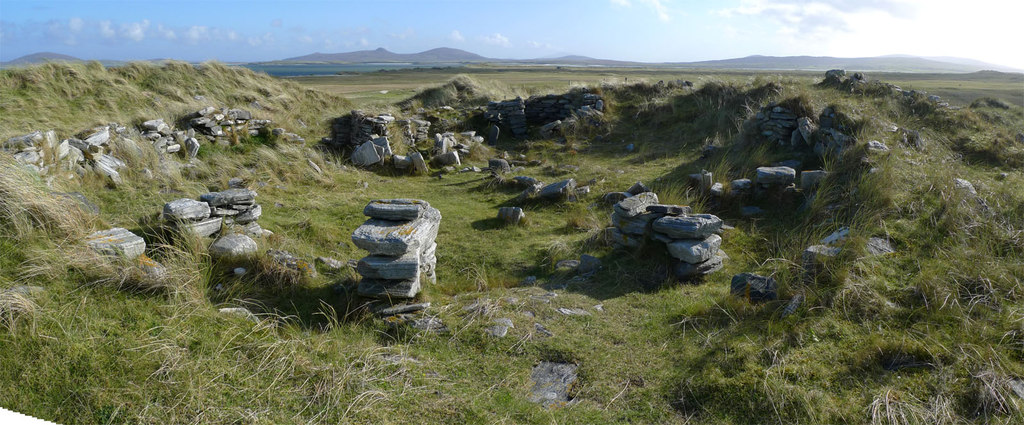
Udal (Grenitote) submitted by Creative Commons : This is a wider view the Wheelhouse at Udal, made by stitching two wide-angle pictures together. It may not be obvious from the picture that the wheelhouse is perched high in a dune. Copyright Rob Burke and licensed for reuse under the Creative Commons Licence. Site in North Uist Scotland (Vote or comment on this photo)

Udal (Grenitote)
Udal (Grenitote) submitted by SandyG : Southern roundhouse. View from above and south west. (Vote or comment on this photo)

Udal (Grenitote)
Udal (Grenitote) submitted by SandyG : Roundhouse standing north of the wheelhouse. View from above and south east. (Vote or comment on this photo)

Udal (Grenitote)
Udal (Grenitote) submitted by SandyG : View from above and north east. (Vote or comment on this photo)

Udal (Grenitote)
Udal (Grenitote) submitted by SandyG : View from above and north.

Udal (Grenitote)
Udal (Grenitote) submitted by SandyG : Structure attached to south west of wheelhouse. View from above and north west.

Udal (Grenitote)
Udal (Grenitote) submitted by SandyG : Wheelhouse. View from above and south.

Udal (Grenitote)
Udal (Grenitote) submitted by SandyG : Excavated roundhouse. This building stands south of the wheelhouse. View from north west (Scale 1m).

Udal (Grenitote)
Udal (Grenitote) submitted by SandyG : Structure attached to the outer south eastern side of the wheelhouse. View from north west.

Udal (Grenitote)
Udal (Grenitote) submitted by SandyG : Wheelhouse. View from north.

Udal (Grenitote)
Udal (Grenitote) submitted by SandyG : Wheelhouse. View from the south.

Udal (Grenitote)
Udal (Grenitote) submitted by SandyG : Settlement remains exposed in the side of a sand dune at NF 82489 78307. View from north east.

Udal (Grenitote)
Udal (Grenitote) submitted by SandyG : Part of the settlement at NF 82553 78343. View from west.

Udal (Grenitote)
Udal (Grenitote) submitted by SandyG : Deep midden deposits are visible in sand dune exposures.

Udal (Grenitote)
Udal (Grenitote) submitted by Creative Commons : Udal midden. The midden is a large heap of shells and some pottery fragments, embedded in sand. It has been excavated, but the amount that remains is impressive. ScotlandsPlaces says that there is evidence of continuous occupation from Neolithic times to the post-medieval period. Copyright Rob Burke and licensed for reuse under the Creative Commons Licence. Site in North Uist Scotla...

Udal (Grenitote)
Udal (Grenitote) submitted by Creative Commons : Midden at Udal. The scale of this enormous midden can be seen by the figure in the distance. Copyright Lis Burke and licensed for reuse under the Creative Commons Licence. Site in North Uist Scotland

Do not use the above information on other web sites or publications without permission of the contributor.
Click here to see more info for this site

Nearby sites

Click here to view sites on an interactive OS map

Key: Red: member's photo, Blue: 3rd party photo, Yellow: other image, Green: no photo - please go there and take one, Grey: site destroyed

Download sites to:
KML (Google Earth)
GPX (GPS waypoints)
CSV (Garmin/Navman)
CSV (Excel)

To unlock full downloads you need to sign up as a Contributory Member. Otherwise downloads are limited to 50 sites.


Turn off the page maps and other distractions

Nearby sites listing. In the following links * = Image available
 3.3km S 181° Dun Toloman Stone Fort or Dun (NF82077492)
 3.5km SSW 203° Dun Skellor Broch or Nuraghe (NF80757507)
 3.7km SSW 214° Sollas, Machair Leathann Ancient Village or Settlement (NF80117533)
 3.7km WSW 238° Leac nan Cailleacha Dubha Standing Stones (NF79087650)
 4.3km WSW 237° Rudh' An Duin Stone Fort or Dun (NF7859376180)
 4.9km ESE 120° Druim na h-Uamha earth house* Souterrain (Fogou, Earth House) (NF86457546)
 5.7km WSW 243° Vallay (N Uist) Rock Art (NF77137600)
 5.8km WSW 245° Bac Mic Connain Stone Fort or Dun (NF76947619)
 5.9km ESE 108° Dun Rosail Stone Fort or Dun (NF87837595)
 6.3km WSW 237° Geirisclett* Chambered Cairn (NF76847520)
 6.3km WSW 239° Bac Mhic Connain Ancient Village or Settlement (NF76737537)
 6.5km SW 228° Garry Iochdrach Ancient Village or Settlement (NF77237427)
 6.5km SW 224° Eilean Maleit Ancient Village or Settlement (NF77487388)
 6.6km SE 138° Maari Standing Stone (Menhir) (NF864729)
 6.7km SW 228° Cnoc A'Comhdhalach Ancient Village or Settlement (NF77087415)
 6.8km E 84° Port nan Long Souterrain (Fogou, Earth House) (NF892784)
 6.9km SW 232° Airigh Mhic Ruairidh* Stone Fort or Dun (NF76597440)
 7.0km E 86° Crois Mhic Jamain* Stone Row / Alignment (NF89397820)
 7.0km SSE 147° Barpa nam Feannag* Chambered Cairn (NF85687204)
 7.3km E 90° Dun an Sticir* Broch or Nuraghe (NF897776)
 7.7km E 95° Beinn A Chaolais Stone Circle (NF900770)
 7.7km SW 223° Buaile Risary Cup Marked Stone Rock Art (NF76697293)
 7.8km SW 223° Buaile Risary Wheelhouse Ancient Village or Settlement (NF76677291)
 7.9km ESE 120° Dun Torcuill Stone Fort or Dun (NF8888573730)
 8.1km SSE 154° Skeal Traval* Stone Row / Alignment (NF8538370672)
View more nearby sites and additional images

<< Stan Low

King's Weston Hillfort >>

Please add your thoughts on this site

An Archaeology of Natural Places

An Archaeology of Natural Places

Sponsors

Auto-Translation (Google)

Translate from English into:

"Udal (Grenitote)" | Login/Create an Account | 5 News and Comments
  
Go back to top of page    Comments are owned by the poster. We aren't responsible for their content.
Re: Rubha an Udail by Andy B on Sunday, 05 July 2020
(User Info | Send a Message)
Hundreds of people have been involved in the
excavation of the Udal site; in 1986 an
exhibition devoted to it was laid on at the British
Museum. Thus the Udal is the most famous
archaeological site in the Uists.

Modem excavation began on the Udal peninsula in 1963
under Iain Crawford, a Cambridge historian, and
continued for most seasons until the mid- I 990s.
Nevertheless, visitors today will find little to
see. Somewhat like Jarlshof in Shetland, the
Udal held the remnants of 5000 years of
settlement, all within a few hundred metres, but
unlike Jarlshof, the Udal was designated a
'research opportunity' by the excavator, and no
attempt was made to conserve the structures.
The Udal splits up into three areas. The earliest
site, called RUX by Crawford, is on the modem
shoreline. It produced Neolithic, Beaker and
Early Bronze Age remains. Inland were two
great mounds of occupation debris, Udal North
and Udal South. Udal North held more recent
structures, Late Iron Age, Pictish, Viking,
Medieval and Post-Medieval remains, arranged
in 30 horizons, spanning near two millennia.
This has been dug to destruction. What remains
resembles a kind of worked-out archaeological
quarry. Between Udal North and South is a
field of deep closely-spaced furrows, scattered
with small stone platforms which held deposits
of cremated bone. Wheelhouse pottery was
found here, and there were also two burials.
Crawford saw the area as the cemetery and
farmland of the last occupiers of Udal South.

More in The Lost Wheelhouses of Uist - a guide to some of the excavated wheelhouses of North & South Uist by Susan Hothersall and Robert Tye.
https://www.academia.edu/356702/
(free registration required)
[ Reply to This ]

Book Review: Life on the Edge: the Neolithic and Bronze Age of Iain Crawford’s Udal by Andy B on Wednesday, 19 December 2018
(User Info | Send a Message)
In 1974, later prehistoric structures, including the remains of a kerb-chambered cairn, were discovered at Udal on the Hebridean island of North Uist. The discovery prompted archaeologist Iain Crawford to undertake a three-year excavation of the site during the early 1990s. This revealed a variety of burial-ritual structures, comprising a stone cist with datable human remains, bowl pits, and two late Neolithic structures incorporated into a larger ritual complex. Crawford also undertook extensive palaeoenvironmental research which revealed clear climate change between the late Neolithic and the early Bronze Age. Using the archaeology and the environmental evidence, he managed to establish a complex narrative for the Udal site.

More at
https://www.archaeology.co.uk/articles/review-life-on-the-edge-the-neolithic-and-bronze-age-of-iain-crawfords-udal-north-uist.htm
[ Reply to This ]

Vote for The Udal at Dig It 2017 by Andy B on Saturday, 17 June 2017
(User Info | Send a Message)
THE UDAL

Take in over 5,000 years of history in a five mile walk! The Udal peninsula and its stunning North Uist landscape setting is one of the longest inhabited areas in northwest Europe, having seen continuous occupation from the first farming communities up to the present day. Excavations have uncovered Neolithic and Iron Age houses, and ritual sites were discovered alongside a Viking fort and a Bronze Age cairn. During the Medieval period, James II of Scotland gave a charter to the MacDonalds of Sleat, which granted possession of North Uist, and named the Udal peninsular as a settlement from which rent could be collected. The whole area is currently being explored and the exciting findings will soon be published.

DON’T MISS
An exhibition of Viking age archaeology including finds from the Udal will be on display at Museum nan Eilean Uist and Barra (Linaclate School, Isle of Benbecula) throughout August 2017.

WHAT KIND OF DAY OUT SHOULD I EXPECT?
Adventurous – People have lived here for thousands of years for a reason! Grab your camera and get out to the peninsula to see it with your own eyes.

WHERE?
North Uist, Na h-Eileanan Siar (Outer Hebrides)

UPCOMING EVENTS
Uist: Island Archaeology in Focus -
https://islandsbooktrust.org/pages/uist-2017-island-archaeology-in-focus

http://www.archaeology.co.uk/specials/the-timeline-of-britain/the-udal.htm

https://www.facebook.com/DigIt2017/photos/a.989156824553423.1073741853.318049228330856/990036424465463/?type=3&theater
[ Reply to This ]

Re: Grant for new research into Western Isles' sand dune-buried artefacts by mpwpir on Sunday, 15 April 2012
(User Info | Send a Message)
An interesting study.
Congratulations.
Alfredo Pirondini
E-mail: mpwpir@gmail.com
[ Reply to This ]

Grant for new research into Western Isles' sand dune-buried artefacts by Andy B on Friday, 13 April 2012
(User Info | Send a Message)
Archaeology at Udal provides an "unbroken timeline" of occupation from the Neolithic, Bronze Age, Iron Age, Viking, Medieval through to the 1900s.

Some of the evidence at the site on North Uist was preserved by wind-blown sand dunes.

Archaeologist Ian Crawford excavated Udal between 1963 and 1995.

Crawford's collection is in the care of Western Isles local authority, Comhairle nan Eilean Siar.

The comhairle believes the site on the Grenitote peninsula to be one of the most important of its kind in the world.

It said the preservation of relics by being buried under sand was rare outside of the Middle East.

The comhairle has received £85,000 from the Museum Association's Esmee Fairbairn Collections Fund to carry out the most complete post-excavation research to be done so far on the site and its finds.

Historic Scotland is assisting with the study.

Money from the grant will also be used to investigate the potential for an archaeological resource centre on North Uist.
Viking re-enactors Evidence of Viking occupation included a longhouse

Councillor Archie Campbell said the £85,000 grant would help islanders and the comhairle achieve a vision.

He said: "The local community has been waiting nearly 50 years to learn about what was discovered beneath the sand dunes and to see the finds for themselves.

"Long before the material was released by Ian Crawford the community made it clear that their wish was for the collections to be returned to the islands on a permanent basis.

"This grant will go towards achieving that vision by funding a feasibility study into the potential of the Udal collections as the basis for an archaeological resource centre and the impact it would have on the islands' economy."

Deborah Anderson, regional archaeologist with the comhairle, welcomed the funding towards better understanding the collection.

She said: "This is an assemblage which is not just important to the Outer Hebrides but which is essential to help date other collections from the west coast of Scotland and Ireland.

Source:
http://www.bbc.co.uk/news/uk-scotland-highlands-islands-16056541

with thanks to Coldrum and bat400 for info
[ Reply to This ]

Your Name: Anonymous [ Register Now ]
Subject:


Add your comment or contribution to this page. Spam or offensive posts are deleted immediately, don't even bother

<<< What is five plus one as a number? (Please type the answer to this question in the little box on the left)
You can also embed videos and other things. For Youtube please copy and paste the 'embed code'.
For Google Street View please include Street View in the text.
Create a web link like this: <a href="https://www.megalithic.co.uk">This is a link</a>  

Allowed HTML is:
<p> <b> <i> <a> <img> <em> <br> <strong> <blockquote> <tt> <li> <ol> <ul> <object> <param> <embed> <iframe>

We would like to know more about this location. Please feel free to add a brief description and any relevant information in your own language.
Wir möchten mehr über diese Stätte erfahren. Bitte zögern Sie nicht, eine kurze Beschreibung und relevante Informationen in Deutsch hinzuzufügen.
Nous aimerions en savoir encore un peu sur les lieux. S'il vous plaît n'hesitez pas à ajouter une courte description et tous les renseignements pertinents dans votre propre langue.
Quisieramos informarnos un poco más de las lugares. No dude en añadir una breve descripción y otros datos relevantes en su propio idioma.