


<< Our Photo Pages >> Battle of the Medway Stone - Modern Stone Circle etc in England in Kent
Submitted by coldrum on Friday, 02 May 2008 Page Views: 10925
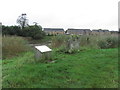
Modern SitesSite Name: Battle of the Medway StoneCountry: England County: Kent Type: Modern Stone Circle etc
Nearest Town: Snodland Nearest Village: Burham
Map Ref: TQ710619
Latitude: 51.330486N Longitude: 0.453136E
Condition:
| 5 | Perfect |
| 4 | Almost Perfect |
| 3 | Reasonable but with some damage |
| 2 | Ruined but still recognisable as an ancient site |
| 1 | Pretty much destroyed, possibly visible as crop marks |
| 0 | No data. |
| -1 | Completely destroyed |
| 5 | Superb |
| 4 | Good |
| 3 | Ordinary |
| 2 | Not Good |
| 1 | Awful |
| 0 | No data. |
| 5 | Can be driven to, probably with disabled access |
| 4 | Short walk on a footpath |
| 3 | Requiring a bit more of a walk |
| 2 | A long walk |
| 1 | In the middle of nowhere, a nightmare to find |
| 0 | No data. |
| 5 | co-ordinates taken by GPS or official recorded co-ordinates |
| 4 | co-ordinates scaled from a detailed map |
| 3 | co-ordinates scaled from a bad map |
| 2 | co-ordinates of the nearest village |
| 1 | co-ordinates of the nearest town |
| 0 | no data |
Internal Links:
External Links:
I have visited· I would like to visit
Majick123 visited on 1st May 2012 - their rating: Cond: 3 Amb: 3 Access: 3 The foot path lies along side the old church of St. Mary, Burham. The stone a good few hundred yards along the path, running alongside the river.
")
A stone set up as a memorial to the Battle of the Medway in 43 AD when British tribes under the command of Caratacus tried to halt the advancing Roman legions and failed.
http://www.burhamvillage.com/historybattleofmedway.htm
http://www.btlse.co.uk/node/5
http://www.kafs.co.uk/magazine/issue6%20Kent.htm
You may be viewing yesterday's version of this page. To see the most up to date information please register for a free account.
")
")
Do not use the above information on other web sites or publications without permission of the contributor.
Nearby Images from Geograph Britain and Ireland:
©2010(licence)
©2010(licence)
©2010(licence)
©2010(licence)
©2014(licence)
The above images may not be of the site on this page, they are loaded from Geograph.
Please Submit an Image of this site or go out and take one for us!
Click here to see more info for this site
Nearby sites
Key: Red: member's photo, Blue: 3rd party photo, Yellow: other image, Green: no photo - please go there and take one, Grey: site destroyed
Download sites to:
KML (Google Earth)
GPX (GPS waypoints)
CSV (Garmin/Navman)
CSV (Excel)
To unlock full downloads you need to sign up as a Contributory Member. Otherwise downloads are limited to 50 sites.
Turn off the page maps and other distractions
Nearby sites listing. In the following links * = Image available
814m NE 56° Burham causewayed enclosure* Causewayed Enclosure (TQ71666238)
2.2km ESE 105° Haly Garden (Burham) Holy Well or Sacred Spring (TQ731614)
2.8km NNE 23° Pilgrims Way 3 Ancient Trackway (TQ720645)
2.9km NNE 31° Wouldham Barrow Round Barrow(s) (TQ72456445)
3.0km E 90° Blue Bell Hill Sarsons Burial Chamber or Dolmen (TQ740620)
3.0km ESE 101° Pilgrim Spring* Holy Well or Sacred Spring (TQ73986140)
3.1km SSW 198° Larkfield Cairnfield (Maidstone) Cairn (TQ70155891)
3.1km ESE 114° Pilgrims Way 4 Ancient Trackway (TQ739607)
3.2km NNW 337° Halling Barrow Round Barrow(s) (TQ69686480)
3.3km ESE 115° Coffin Stone* Standing Stone (Menhir) (TQ74016059)
3.3km ESE 119° Great Tottington Farm Natural Stone / Erratic / Other Natural Feature (TQ73956038)
3.6km NNW 344° Pilgrims Way 1 Ancient Trackway (TQ699653)
3.6km ESE 120° Tottington Stone* Standing Stone (Menhir) (TQ7418660231)
3.6km ESE 109° Kit's Coty.* Burial Chamber or Dolmen (TQ7448660856)
3.7km ESE 116° Little Kit's Coty* Burial Chamber or Dolmen (TQ74426040)
3.8km NNE 29° Shoulder of Mutton Wood Bowl Barrow* Round Barrow(s) (TQ72716525)
4.0km ESE 122° Cossington Spring* Holy Well or Sacred Spring (TQ745599)
4.4km ESE 117° Aylesford Megalith Long Barrow (TQ750600)
4.4km ESE 114° Lower White Horse Stone* Standing Stone (Menhir) (TQ75126022)
4.5km ESE 110° Smythe's Megalith Chambered Tomb (TQ753605)
4.5km ESE 113° White Horse Stone Neolithic Longhouse Ancient Village or Settlement (TQ7525060250)
4.6km WNW 295° Dode Church Well* Holy Well or Sacred Spring (TQ668637)
4.6km ESE 112° White Horse Stone* Chambered Tomb (TQ75356032)
5.0km E 93° Stones off Impton Lane* Natural Stone / Erratic / Other Natural Feature (TQ7601561793)
5.0km W 260° Ryarsh Sarson Stones Natural Stone / Erratic / Other Natural Feature (TQ66076089)
View more nearby sites and additional images


 We would like to know more about this location. Please feel free to add a brief description and any relevant information in your own language.
 Wir möchten mehr über diese Stätte erfahren. Bitte zögern Sie nicht, eine kurze Beschreibung und relevante Informationen in Deutsch hinzuzufügen.
 Nous aimerions en savoir encore un peu sur les lieux. S'il vous plaît n'hesitez pas à ajouter une courte description et tous les renseignements pertinents dans votre propre langue.
 Quisieramos informarnos un poco más de las lugares. No dude en añadir una breve descripción y otros datos relevantes en su propio idioma.