<< Our Photo Pages >> Mutlow Hill - Round Barrow(s) in England in Cambridgeshire
Submitted by ermine on Monday, 04 October 2004 Page Views: 12266
Neolithic and Bronze AgeSite Name: Mutlow Hill Alternative Name: Fleam DykeCountry: England County: Cambridgeshire Type: Round Barrow(s)
Nearest Town: Cambridge Nearest Village: Fulbourn
Map Ref: TL5466354380
Latitude: 52.166020N Longitude: 0.259939E
Condition:
| 5 | Perfect |
| 4 | Almost Perfect |
| 3 | Reasonable but with some damage |
| 2 | Ruined but still recognisable as an ancient site |
| 1 | Pretty much destroyed, possibly visible as crop marks |
| 0 | No data. |
| -1 | Completely destroyed |
| 5 | Superb |
| 4 | Good |
| 3 | Ordinary |
| 2 | Not Good |
| 1 | Awful |
| 0 | No data. |
| 5 | Can be driven to, probably with disabled access |
| 4 | Short walk on a footpath |
| 3 | Requiring a bit more of a walk |
| 2 | A long walk |
| 1 | In the middle of nowhere, a nightmare to find |
| 0 | No data. |
| 5 | co-ordinates taken by GPS or official recorded co-ordinates |
| 4 | co-ordinates scaled from a detailed map |
| 3 | co-ordinates scaled from a bad map |
| 2 | co-ordinates of the nearest village |
| 1 | co-ordinates of the nearest town |
| 0 | no data |
Internal Links:
External Links:
I have visited· I would like to visit
ermine has visited here
")
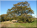
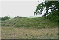
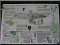
This must have been one of the largest Bronze Age (c 2000BC) round barrows on the Icknield and was used to line up the later Fleam Dyke (Saxon defence).
Update December 2017: The Northern Antiquarian (TNA) features a page for this site - see their entry for Mutlow Hill, Great Wilbraham, Cambridge, which gives directions for finding this location, together with a brief archaeology & history and local folklore.
This round barrow is also recorded as Pastscape Monument No. 374551 and scheduled as Historic England List ID 1006932. The HE entry currently has no details, except a 10 digit NGR, having been generated from an Old County Number. The Pastscape summary tells us: "Tumulus (bowl barrow)(two ring ditches). Mutlow Hill Bowl Barrow and moot is situated on a chalk knoll on the Earl Medieval Fleam Dyke standing between the junction of two prehistoric trackways. Secondary Saxon inhumations were uncovered by workmen in 1847 but have been attributed to Wendens Ambo, Essex, perhaps in error." Click on the Pastscape link for more details.
You may be viewing yesterday's version of this page. To see the most up to date information please register for a free account.
Do not use the above information on other web sites or publications without permission of the contributor.
Nearby Images from Geograph Britain and Ireland:
©2008(licence)
©2013(licence)
©2022(licence)
©2010(licence)
©2010(licence)
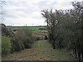
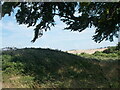
The above images may not be of the site on this page, they are loaded from Geograph.
Please Submit an Image of this site or go out and take one for us!
Click here to see more info for this site
Nearby sites
Key: Red: member's photo, Blue: 3rd party photo, Yellow: other image, Green: no photo - please go there and take one, Grey: site destroyed
Download sites to:
KML (Google Earth)
GPX (GPS waypoints)
CSV (Garmin/Navman)
CSV (Excel)
To unlock full downloads you need to sign up as a Contributory Member. Otherwise downloads are limited to 50 sites.
Turn off the page maps and other distractions
Nearby sites listing. In the following links * = Image available
4.0km WSW 252° Copley Hill* Round Barrow(s) (TL509530)
4.1km WSW 246° Babraham* Long Barrow (TL510526)
5.2km WSW 254° Wormwood Hill* Round Barrow(s) (TL497528)
5.4km W 261° Wandlebury* Hillfort (TL493534)
5.5km W 262° Gog and Magog Giants Hill Figures* Hill Figure or Geoglyph (TL492534)
6.2km WNW 282° East Pit Nature Reserve* Ancient Village or Settlement (TL485555)
6.3km WNW 289° The Kingship Stone, Cherry Hinton Natural Stone / Erratic / Other Natural Feature (TL486562)
7.5km N 2° Bottisham Cursus Cursus (TL547619)
8.3km W 271° Nine wells* Holy Well or Sacred Spring (TL46305420)
9.7km S 175° St. Botolph's Well (Hadstock)* Holy Well or Sacred Spring (TL55864478)
9.7km WSW 255° Little Shelford Crosses* Ancient Cross (TL453516)
10.3km SSE 159° Bartlow Hills* Barrow Cemetery (TL586449)
10.3km WNW 292° Cambridge Fitzwilliam Museum* Museum (TL44955790)
10.3km WNW 293° Cambridge Museum of Archaeology & Anthropology* Museum (TL450581)
10.7km NNE 20° Devil's Dyke, Cambridgeshire* Misc. Earthwork (TL580646)
11.7km SW 236° Chronicle Hills Barrow Cemetery (TL452475)
12.1km NNE 18° The Burwells* Holy Well or Sacred Spring (TL5866)
12.6km SSE 164° Lady Well (Ashdon) Holy Well or Sacred Spring (TL586424)
12.7km SW 236° Thriplow Round Barrow(s) (TL4431646901)
13.3km SW 229° Thriplow Ring Ditch Misc. Earthwork (TL44784537)
13.7km SW 228° Thriplow Heath 1 Round Barrow(s) (TL4479044782)
14.1km SSW 209° Valance Farm Round Barrow(s) (TL4823241818)
14.1km SE 126° Haverhill marker stone* Marker Stone (TL6633546395)
15.4km SW 227° Thrplow Heath 2 Round Barrow(s) (TL4362943549)
15.6km S 188° Saffron Walden Puddingstone* Natural Stone / Erratic / Other Natural Feature (TL530389)
View more nearby sites and additional images


 We would like to know more about this location. Please feel free to add a brief description and any relevant information in your own language.
 Wir möchten mehr über diese Stätte erfahren. Bitte zögern Sie nicht, eine kurze Beschreibung und relevante Informationen in Deutsch hinzuzufügen.
 Nous aimerions en savoir encore un peu sur les lieux. S'il vous plaît n'hesitez pas à ajouter une courte description et tous les renseignements pertinents dans votre propre langue.
 Quisieramos informarnos un poco más de las lugares. No dude en añadir una breve descripción y otros datos relevantes en su propio idioma.