 with our Megalithic Portal iPhone app")


<< Text Pages >> Philpots Camp Mesolithic Rock Shelters - Cave or Rock Shelter in England in West Sussex
Submitted by coldrum on Friday, 27 November 2020 Page Views: 1303
Natural PlacesSite Name: Philpots Camp Mesolithic Rock SheltersCountry: England County: West Sussex Type: Cave or Rock Shelter
Nearest Village: Ardingly
Map Ref: TQ34873212
Latitude: 51.072569N Longitude: 0.076295W
Condition:
| 5 | Perfect |
| 4 | Almost Perfect |
| 3 | Reasonable but with some damage |
| 2 | Ruined but still recognisable as an ancient site |
| 1 | Pretty much destroyed, possibly visible as crop marks |
| 0 | No data. |
| -1 | Completely destroyed |
| 5 | Superb |
| 4 | Good |
| 3 | Ordinary |
| 2 | Not Good |
| 1 | Awful |
| 0 | No data. |
| 5 | Can be driven to, probably with disabled access |
| 4 | Short walk on a footpath |
| 3 | Requiring a bit more of a walk |
| 2 | A long walk |
| 1 | In the middle of nowhere, a nightmare to find |
| 0 | No data. |
| 5 | co-ordinates taken by GPS or official recorded co-ordinates |
| 4 | co-ordinates scaled from a detailed map |
| 3 | co-ordinates scaled from a bad map |
| 2 | co-ordinates of the nearest village |
| 1 | co-ordinates of the nearest town |
| 0 | no data |
Be the first person to rate this site - see the 'Contribute!' box in the right hand menu.
Internal Links:
External Links:
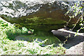
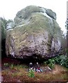
Rock Shelter in West Sussex
From Heritage Gateway:
"The earlier prehistoric rock shelters are situated beneath the overhanging rocks of the natural cliffs which form the south western and south eastern edges of the monument."
https://www.heritagegateway.org.uk/Gateway/Results_Single.aspx?uid=MWS5805&resourceID=1032
You may be viewing yesterday's version of this page. To see the most up to date information please register for a free account.
Do not use the above information on other web sites or publications without permission of the contributor.
Nearby Images from Geograph Britain and Ireland:

©2010(licence)

©2010(licence)
©2010(licence)

©2010(licence)
©2006(licence)
The above images may not be of the site on this page, they are loaded from Geograph.
Please Submit an Image of this site or go out and take one for us!
Click here to see more info for this site
Nearby sites
Key: Red: member's photo, Blue: 3rd party photo, Yellow: other image, Green: no photo - please go there and take one, Grey: site destroyed
Download sites to:
KML (Google Earth)
GPX (GPS waypoints)
CSV (Garmin/Navman)
CSV (Excel)
To unlock full downloads you need to sign up as a Contributory Member. Otherwise downloads are limited to 50 sites.
Turn off the page maps and other distractions
Nearby sites listing. In the following links * = Image available
139m SSW 212° Big on Little* Rock Outcrop (TQ348320)
193m NNW 340° Philpots Promontory Camp* Hillfort (TQ348323)
2.9km E 89° St Mary's Rocks Cave or Rock Shelter (TQ37773226)
3.4km NW 308° Ashdown Forest - Horsham ridgeway Ancient Trackway (TQ32153416)
4.0km NNE 33° Cinder Mead and Furnace Mead Ancient Mine, Quarry or other Industry (TQ37003552)
4.1km NE 53° Stone Rocks West Sussex Cave or Rock Shelter (TQ381347)
4.4km NNE 33° Ridge Hill Rock Shelter Cave or Rock Shelter (TQ37203590)
6.6km ESE 102° The Danes Churchyard Ancient Village or Settlement (TQ41343089)
7.6km NE 40° East Grinstead Museum* Museum (TQ3960338031)
7.7km NE 55° Blunds Hole Cave or Rock Shelter (TQ41103670)
7.9km WSW 253° Mesolithic settlement near Pulpit Rock* Ancient Village or Settlement (TQ27362955)
8.3km E 90° Ashdown Forest Centre* Museum (TQ432323)
9.5km E 93° The Park Fort (Ashdown Forest) Hillfort (TQ44373195)
9.9km E 95° Birch Wood Ironworks Ancient Mine, Quarry or other Industry (TQ448316)
10.0km ESE 109° Millbrook Barrow Round Barrow(s) (TQ444291)
10.5km W 276° Blackhill Barrow Round Barrow(s) (TQ244330)
11.0km W 277° Shepherdsfield Barrow Round Barrow(s) (TQ239332)
11.9km E 92° A.A.Milne & E.H.Shephard Memorial* Modern Stone Circle etc (TQ468321)
11.9km E 96° Peat Lump Hill* Round Barrow(s) (TQ46773120)
12.1km ESE 110° Duddleswell Round Barrow(s) (TQ463282)
12.5km E 95° Greenwood Gate Clump Enclosure Ancient Village or Settlement (TQ47373127)
12.6km E 88° Lone Oak Spring Holy Well or Sacred Spring (TQ475328)
12.7km NE 42° Dry Hill Fort* Hillfort (TQ432417)
12.8km NNE 18° St. Margaret's Well (Lingfield)* Holy Well or Sacred Spring (TQ386444)
13.0km ESE 102° Kings Standing* Ancient Village or Settlement (TQ477298)
View more nearby sites and additional images
<< Steyning Round Hill Cross Dyke
Muntham Court Iron Age/Romano British Settlement/Shrine/Well >>


 We would like to know more about this location. Please feel free to add a brief description and any relevant information in your own language.
 Wir möchten mehr über diese Stätte erfahren. Bitte zögern Sie nicht, eine kurze Beschreibung und relevante Informationen in Deutsch hinzuzufügen.
 Nous aimerions en savoir encore un peu sur les lieux. S'il vous plaît n'hesitez pas à ajouter une courte description et tous les renseignements pertinents dans votre propre langue.
 Quisieramos informarnos un poco más de las lugares. No dude en añadir una breve descripción y otros datos relevantes en su propio idioma.