<< Our Photo Pages >> Seamer Beacon - Round Barrow(s) in England in Yorkshire (North)
Submitted by rogerkread on Wednesday, 06 November 2019 Page Views: 2299
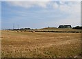
Neolithic and Bronze AgeSite Name: Seamer BeaconCountry: England County: Yorkshire (North) Type: Round Barrow(s)
Nearest Town: Scarborough
Map Ref: TA008876
Latitude: 54.274121N Longitude: 0.453532W
Condition:
| 5 | Perfect |
| 4 | Almost Perfect |
| 3 | Reasonable but with some damage |
| 2 | Ruined but still recognisable as an ancient site |
| 1 | Pretty much destroyed, possibly visible as crop marks |
| 0 | No data. |
| -1 | Completely destroyed |
| 5 | Superb |
| 4 | Good |
| 3 | Ordinary |
| 2 | Not Good |
| 1 | Awful |
| 0 | No data. |
| 5 | Can be driven to, probably with disabled access |
| 4 | Short walk on a footpath |
| 3 | Requiring a bit more of a walk |
| 2 | A long walk |
| 1 | In the middle of nowhere, a nightmare to find |
| 0 | No data. |
| 5 | co-ordinates taken by GPS or official recorded co-ordinates |
| 4 | co-ordinates scaled from a detailed map |
| 3 | co-ordinates scaled from a bad map |
| 2 | co-ordinates of the nearest village |
| 1 | co-ordinates of the nearest town |
| 0 | no data |
Internal Links:
External Links:
")
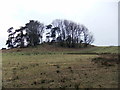
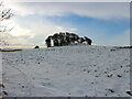
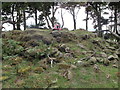
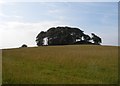
The main one is approximately 1m high and 10m in diameter. It has suffered from being the site of a mediaeval beacon and then a C19th folly. Still well worth a visit and there are several other barrows nearby.
You may be viewing yesterday's version of this page. To see the most up to date information please register for a free account.
")
")
")
Do not use the above information on other web sites or publications without permission of the contributor.
Nearby Images from Geograph Britain and Ireland:
©2018(licence)
©2023(licence)
©2013(licence)
©2014(licence)
©2014(licence)
The above images may not be of the site on this page, they are loaded from Geograph.
Please Submit an Image of this site or go out and take one for us!
Click here to see more info for this site
Nearby sites
Key: Red: member's photo, Blue: 3rd party photo, Yellow: other image, Green: no photo - please go there and take one, Grey: site destroyed
Download sites to:
KML (Google Earth)
GPX (GPS waypoints)
CSV (Garmin/Navman)
CSV (Excel)
To unlock full downloads you need to sign up as a Contributory Member. Otherwise downloads are limited to 50 sites.
Turn off the page maps and other distractions
Nearby sites listing. In the following links * = Image available
1.4km SW 215° East Ayton Long Barrow Long Barrow (TA000864)
2.0km E 91° Falsgrave Park Circle* Modern Stone Circle etc (TA028876)
3.6km E 81° Rotunda Museum* Museum (TA0432588255)
4.2km SSE 151° Crossgates Stone (Seamer) Natural Stone / Erratic / Other Natural Feature (TA02948398)
4.5km ENE 72° Our Lady's Well (Scarborough)* Holy Well or Sacred Spring (TA051891)
4.8km NW 312° St Hilda's Holy Well* Holy Well or Sacred Spring (SE9714890729)
4.9km NW 309° Hackness Church* Ancient Cross (SE96919056)
5.0km W 267° California Belt Round Barrows Barrow Cemetery (SE95808719)
5.1km W 267° Fox Head Round Barrow* Round Barrow(s) (SE95748723)
5.7km WNW 290° Wykeham Forest Iron Age Square Barrow Cemetery Misc. Earthwork (SE954894)
5.8km W 276° Loft Howe* Round Barrow(s) (SE95018804)
6.9km SSE 164° Star Carr* Ancient Village or Settlement (TA0282181013)
8.4km N 358° Cloughton Moor Stone Circle (TA0036595947)
9.5km NNW 346° Linglands Farm NW (Hardwood Dale) Cairn (SE9830296749)
9.5km ESE 119° Gristhorpe Tumuli* Round Barrow(s) (TA093832)
9.7km NNW 345° Linglands Farm Cairnfields (Hardwood Dale) Cairn (SE9804796859)
9.7km NNW 346° Harwood Dale* Stone Circle (SE9824796976)
10.5km SSE 148° Spell Howe (Folkton) Cairn (TA06577878)
10.6km W 263° Rob Howe Long Barrow Long Barrow (SE90308600)
10.7km SSE 159° Sharp Howes* Barrow Cemetery (TA049777)
10.9km WNW 287° Three Howes (South Moor)* Round Barrow(s) (SE90329063)
10.9km SSE 163° Elf Howe Round Barrow(s) (TA04227725)
11.0km SSE 154° Folkton Round Barrow* Round Barrow(s) (TA059778)
11.1km WNW 289° Fox Howe* Round Barrow(s) (SE90249096)
11.2km NNW 339° Three Howes (Hallow Rigg)* Barrow Cemetery (SE9659998032)
View more nearby sites and additional images


 We would like to know more about this location. Please feel free to add a brief description and any relevant information in your own language.
 Wir möchten mehr über diese Stätte erfahren. Bitte zögern Sie nicht, eine kurze Beschreibung und relevante Informationen in Deutsch hinzuzufügen.
 Nous aimerions en savoir encore un peu sur les lieux. S'il vous plaît n'hesitez pas à ajouter une courte description et tous les renseignements pertinents dans votre propre langue.
 Quisieramos informarnos un poco más de las lugares. No dude en añadir una breve descripción y otros datos relevantes en su propio idioma.