<< Our Photo Pages >> Culverswell Barrow - Round Barrow(s) in England in Surrey
Submitted by michaelpeer on Saturday, 11 August 2018 Page Views: 1940
Neolithic and Bronze AgeSite Name: Culverswell BarrowCountry: England
NOTE: This site is 0.4 km away from the location you searched for.
County: Surrey Type: Round Barrow(s)
Nearest Village: Elstead
Map Ref: SU892456
Latitude: 51.202659N Longitude: 0.72462W
Condition:
| 5 | Perfect |
| 4 | Almost Perfect |
| 3 | Reasonable but with some damage |
| 2 | Ruined but still recognisable as an ancient site |
| 1 | Pretty much destroyed, possibly visible as crop marks |
| 0 | No data. |
| -1 | Completely destroyed |
| 5 | Superb |
| 4 | Good |
| 3 | Ordinary |
| 2 | Not Good |
| 1 | Awful |
| 0 | No data. |
| 5 | Can be driven to, probably with disabled access |
| 4 | Short walk on a footpath |
| 3 | Requiring a bit more of a walk |
| 2 | A long walk |
| 1 | In the middle of nowhere, a nightmare to find |
| 0 | No data. |
| 5 | co-ordinates taken by GPS or official recorded co-ordinates |
| 4 | co-ordinates scaled from a detailed map |
| 3 | co-ordinates scaled from a bad map |
| 2 | co-ordinates of the nearest village |
| 1 | co-ordinates of the nearest town |
| 0 | no data |
Internal Links:
External Links:
")
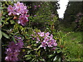
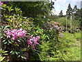
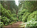
This alignment passes through the ancient site, with a possible recumbent stone. of Wanborough Church, and finishes at Crooksbury Barrows. Culverswell Barrow was found to be precisely on this line in a forest of pines. The pines have now been felled and the barrow is revealed as shown in the photographs.
It has been verified by Surrey Archaeology and added to their HER register. You can find full details of the barrow and alignment on my website Surrey's Ritual Landscape and navigate to the Crooksbury Line entry.
You may be viewing yesterday's version of this page. To see the most up to date information please register for a free account.
")
")
")
Do not use the above information on other web sites or publications without permission of the contributor.
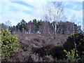
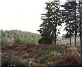
Nearby Images from Geograph Britain and Ireland:
©2012(licence)
©2008(licence)
©2012(licence)
©2008(licence)
©2015(licence)
The above images may not be of the site on this page, they are loaded from Geograph.
Please Submit an Image of this site or go out and take one for us!
Click here to see more info for this site
Nearby sites
Key: Red: member's photo, Blue: 3rd party photo, Yellow: other image, Green: no photo - please go there and take one, Grey: site destroyed
Download sites to:
KML (Google Earth)
GPX (GPS waypoints)
CSV (Garmin/Navman)
CSV (Excel)
To unlock full downloads you need to sign up as a Contributory Member. Otherwise downloads are limited to 50 sites.
Turn off the page maps and other distractions
Nearby sites listing. In the following links * = Image available
608m S 172° Crooksbury Common Barrows* Barrow Cemetery (SU893450)
1.3km SSW 194° Tilford Barrows Barrow Cemetery (SU889443)
1.3km WNW 298° Soldier's Ring* Hillfort (SU880462)
1.8km WNW 290° Botany Hill Camp Hillfort (SU875462)
2.2km W 274° St. Mary's Well (Compton)* Holy Well or Sacred Spring (SU870457)
2.2km ENE 59° Hillbury hillfort* Hillfort (SU911468)
3.9km NW 308° Badshot Lea* Long Barrow (SU86084793)
6.2km SW 219° Frensham Common Barrows* Barrow Cemetery (SU85334070)
7.2km NW 309° Caesar's Camp (Hampshire)* Hillfort (SU835501)
7.4km NW 324° Bat's Hogsty* Misc. Earthwork (SU84685152)
8.0km WNW 299° Heath Brow Barrows* Barrow Cemetery (SU82184937)
8.2km NNW 344° Barrow on Queen's Hotel roundabout* Round Barrow(s) (SU8682953432)
8.3km ESE 116° Lady Well (Tuesley)* Holy Well or Sacred Spring (SU968421)
10.3km ENE 72° St. Edward's Well* Holy Well or Sacred Spring (SU9949)
10.5km ENE 77° Artington Spring* Holy Well or Sacred Spring (SU994482)
11.1km ENE 72° Guildford Museum* Museum (SU9968349258)
11.3km NNE 31° Bullswater Common Barrows Barrow Cemetery (SU9487555356)
11.7km WSW 253° Binsted Cursus Cursus (SU7842)
11.9km SSW 198° Wishing Well at Waggoners Wells* Holy Well or Sacred Spring (SU857342)
12.6km S 175° Haslemere Educational Museum* Museum (SU9061833107)
13.1km NE 53° Whitmoor Common* Round Barrow(s) (SU996536)
13.2km ESE 123° Hascombe Hill* Hillfort (TQ004386)
13.2km ENE 78° Tyting Farm Bowl Barrow* Round Barrow(s) (TQ02124857)
13.7km E 80° St Martha's on the Hill Earth Circles* Misc. Earthwork (TQ027482)
13.8km ESE 122° The Dragonstones Modern Stone Circle etc (TQ0105038489)
View more nearby sites and additional images


 We would like to know more about this location. Please feel free to add a brief description and any relevant information in your own language.
 Wir möchten mehr über diese Stätte erfahren. Bitte zögern Sie nicht, eine kurze Beschreibung und relevante Informationen in Deutsch hinzuzufügen.
 Nous aimerions en savoir encore un peu sur les lieux. S'il vous plaît n'hesitez pas à ajouter une courte description et tous les renseignements pertinents dans votre propre langue.
 Quisieramos informarnos un poco más de las lugares. No dude en añadir una breve descripción y otros datos relevantes en su propio idioma.