<< Our Photo Pages >> Flat Howe (Sleights Moor) - Round Barrow(s) in England in Yorkshire (North)
Submitted by vicky on Sunday, 21 July 2002 Page Views: 8865
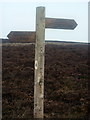
Neolithic and Bronze AgeSite Name: Flat Howe (Sleights Moor)Country: England County: Yorkshire (North) Type: Round Barrow(s)
Map Ref: NZ85510461 Landranger Map Number: 94
Latitude: 54.429734N Longitude: 0.683387W
Condition:
| 5 | Perfect |
| 4 | Almost Perfect |
| 3 | Reasonable but with some damage |
| 2 | Ruined but still recognisable as an ancient site |
| 1 | Pretty much destroyed, possibly visible as crop marks |
| 0 | No data. |
| -1 | Completely destroyed |
| 5 | Superb |
| 4 | Good |
| 3 | Ordinary |
| 2 | Not Good |
| 1 | Awful |
| 0 | No data. |
| 5 | Can be driven to, probably with disabled access |
| 4 | Short walk on a footpath |
| 3 | Requiring a bit more of a walk |
| 2 | A long walk |
| 1 | In the middle of nowhere, a nightmare to find |
| 0 | No data. |
| 5 | co-ordinates taken by GPS or official recorded co-ordinates |
| 4 | co-ordinates scaled from a detailed map |
| 3 | co-ordinates scaled from a bad map |
| 2 | co-ordinates of the nearest village |
| 1 | co-ordinates of the nearest town |
| 0 | no data |
Internal Links:
External Links:
I have visited· I would like to visit
kthdsn visited on 20th Jul 2014 - their rating: Cond: 3 Amb: 3 Access: 5
 (PID:172208)")
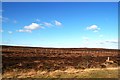
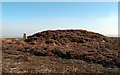
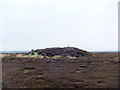
On a good day they can be seen from miles around.
You may be viewing yesterday's version of this page. To see the most up to date information please register for a free account.
 (PID:172207)")
 (PID:172206)")
 (PID:172205)")
 (PID:172204)")
Do not use the above information on other web sites or publications without permission of the contributor.
Nearby Images from Geograph Britain and Ireland:
©2012(licence)
©2011(licence)
©2018(licence)
©2019(licence)
©2011(licence)
The above images may not be of the site on this page, they are loaded from Geograph.
Please Submit an Image of this site or go out and take one for us!
Click here to see more info for this site
Nearby sites
Key: Red: member's photo, Blue: 3rd party photo, Yellow: other image, Green: no photo - please go there and take one, Grey: site destroyed
Download sites to:
KML (Google Earth)
GPX (GPS waypoints)
CSV (Garmin/Navman)
CSV (Excel)
To unlock full downloads you need to sign up as a Contributory Member. Otherwise downloads are limited to 50 sites.
Turn off the page maps and other distractions
Nearby sites listing. In the following links * = Image available
512m W 273° High Bridestones (Yorks)* Stone Circle (NZ8499704629)
897m S 173° Pen Howe (Sleights Moor)* Round Barrow(s) (NZ8563903722)
983m W 277° Low Bridestones (S) (Yorks)* Stone Row / Alignment (NZ84530472)
999m WNW 286° Low Bridestones (N) (Yorks)* Standing Stones (NZ84540486)
1.2km S 187° Breckon Howe (Sleights Moor)* Round Barrow(s) (NZ8537603406)
1.7km SE 129° Greenland's Howe (Sleights Moor)* Cist (NZ8688103552)
1.8km S 191° Sil Howe* Round Barrow(s) (NZ8519002830)
1.9km SW 234° Stony Rigg RB1 (Goathland Moor)* Round Barrow(s) (NZ8395703441)
2.0km SSE 161° Flass Brow Marker Stones* Marker Stone (NZ8620802708)
2.3km SSE 169° Flass Brow Round Barrow* Round Barrow(s) (NZ860024)
2.9km WSW 239° Allan Tofts 2d* Rock Art (NZ8303503047)
2.9km WSW 240° Allan Tofts 2b* Rock Art (NZ8300503083)
2.9km SW 234° Allan Tofts 9* Rock Art (NZ8316902842)
2.9km WSW 239° Allan Tofts 2c* Rock Art (NZ8300503059)
3.0km SSE 154° Robbed Howe* Round Barrow(s) (NZ8685001958)
3.0km WSW 239° Allan Tofts 2e* Rock Art (NZ8298903016)
3.0km WSW 239° Allan Tofts 2g* Rock Art (NZ8294903016)
3.2km WSW 239° Allan Tofts 4b* Rock Art (NZ8283002928)
3.2km SW 235° Allan Tofts 7* Rock Art (NZ8294502747)
3.4km WSW 239° Allan Tofts 5c* Rock Art (NZ8265502816)
3.4km N 9° Aislaby Moor Rock Art (NZ8608)
3.7km SW 234° Pennock Puzzle Stone* Carving (NZ8252902337)
3.9km SE 144° York Cross (Sneaton High Moor)* Ancient Cross (NZ8785901524)
4.1km SSE 153° Foster Howes* Round Barrow(s) (NZ8744800991)
4.3km NNW 342° Swarth Howe Cross* Ancient Cross (NZ8412508649)
View more nearby sites and additional images


 We would like to know more about this location. Please feel free to add a brief description and any relevant information in your own language.
 Wir möchten mehr über diese Stätte erfahren. Bitte zögern Sie nicht, eine kurze Beschreibung und relevante Informationen in Deutsch hinzuzufügen.
 Nous aimerions en savoir encore un peu sur les lieux. S'il vous plaît n'hesitez pas à ajouter une courte description et tous les renseignements pertinents dans votre propre langue.
 Quisieramos informarnos un poco más de las lugares. No dude en añadir una breve descripción y otros datos relevantes en su propio idioma.