<< Text Pages >> Exbury - Promontory Fort / Cliff Castle in England in Hampshire
Submitted by JimChampion on Thursday, 02 June 2005 Page Views: 6368
Iron Age and Later PrehistorySite Name: ExburyCountry: England County: Hampshire Type: Promontory Fort / Cliff Castle
Nearest Village: Exbury
Map Ref: SZ419987
Latitude: 50.786364N Longitude: 1.406983W
Condition:
| 5 | Perfect |
| 4 | Almost Perfect |
| 3 | Reasonable but with some damage |
| 2 | Ruined but still recognisable as an ancient site |
| 1 | Pretty much destroyed, possibly visible as crop marks |
| 0 | No data. |
| -1 | Completely destroyed |
| 5 | Superb |
| 4 | Good |
| 3 | Ordinary |
| 2 | Not Good |
| 1 | Awful |
| 0 | No data. |
| 5 | Can be driven to, probably with disabled access |
| 4 | Short walk on a footpath |
| 3 | Requiring a bit more of a walk |
| 2 | A long walk |
| 1 | In the middle of nowhere, a nightmare to find |
| 0 | No data. |
| 5 | co-ordinates taken by GPS or official recorded co-ordinates |
| 4 | co-ordinates scaled from a detailed map |
| 3 | co-ordinates scaled from a bad map |
| 2 | co-ordinates of the nearest village |
| 1 | co-ordinates of the nearest town |
| 0 | no data |
Be the first person to rate this site - see the 'Contribute!' box in the right hand menu.
Internal Links:
External Links:
Promontory Fort in Hampshire
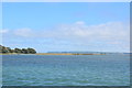
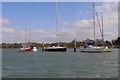
Iron Age promontory fort enclosing just under 10 acres in the New Forest. It is defended on the west by the River Beaulieu and on east by a bank and outer ditch. [source]
You may be viewing yesterday's version of this page. To see the most up to date information please register for a free account.
Do not use the above information on other web sites or publications without permission of the contributor.
Nearby Images from Geograph Britain and Ireland:
©2020(licence)
©2015(licence)
©2007(licence)
©2015(licence)
©2008(licence)
The above images may not be of the site on this page, they are loaded from Geograph.
Please Submit an Image of this site or go out and take one for us!
Click here to see more info for this site
Nearby sites
Key: Red: member's photo, Blue: 3rd party photo, Yellow: other image, Green: no photo - please go there and take one, Grey: site destroyed
Download sites to:
KML (Google Earth)
GPX (GPS waypoints)
CSV (Garmin/Navman)
CSV (Excel)
To unlock full downloads you need to sign up as a Contributory Member. Otherwise downloads are limited to 50 sites.
Turn off the page maps and other distractions
Nearby sites listing. In the following links * = Image available
4.4km NNW 349° Beaulieu Heath (East)* Round Barrow(s) (SU4103)
5.0km NE 53° Poppy Pond* Round Barrow(s) (SU45920174)
5.1km ENE 59° Talia's Torque* Round Barrow(s) (SU46240138)
7.3km NW 324° Culverley Farm Bowl Barrow Round Barrow(s) (SU37530461)
7.8km W 275° Laurences Barrow* Round Barrow(s) (SZ34139937)
8.0km W 280° Beaulieu Heath (West)* Round Barrow(s) (SU3400)
8.1km NNW 336° Dibden Bottom* Barrow Cemetery (SU385061)
8.2km NNW 344° Darcy Island* Round Barrow(s) (SU39520654)
8.7km NNW 341° The Dibden-Lynch Bottom Ring Henge
8.7km NNW 345° Tricia's Tor* Barrow Cemetery (SU3960807074)
8.8km NW 314° Deny Lodge Cattle Pen* Artificial Mound (SU3548404771)
8.8km WNW 291° Pudding Barrow* Round Barrow(s) (SU336018)
9.2km NNW 340° Ipley Cross* Round Barrow(s) (SU38670735)
9.7km SSE 156° Vittlefields Farm Bowl Barrow* Round Barrow(s) (SZ4592389814)
9.9km NW 323° Yew Tree Heath* Round Barrow(s) (SU3589506556)
10.1km SSW 211° Bouldnor Underwater Settlement and Wooden Structure* Ancient Trackway (SZ367900)
10.5km W 260° Buckland Rings* Ancient Village or Settlement (SZ315968)
11.1km NNW 330° Longdown (New Forest) tumuli* Round Barrow(s) (SU363083)
11.7km SSE 167° Round Copse* Round Barrow(s) (SZ447873)
12.2km SSE 160° Bowcombe Down* Round Barrow(s) (SZ461872)
12.3km W 277° Setley Plain disc barrows* Round Barrow(s) (SU29620002)
12.4km W 270° Shirley Holms* Round Barrow(s) (SZ295985)
12.6km NW 319° Matley Heath* Round Barrow(s) (SU336082)
12.7km S 173° Newbarn Combe Enclosures Ancient Village or Settlement (SZ435861)
12.8km NW 320° Ashurst Lodge Earthworks* Misc. Earthwork (SU336085)
View more nearby sites and additional images


 We would like to know more about this location. Please feel free to add a brief description and any relevant information in your own language.
 Wir möchten mehr über diese Stätte erfahren. Bitte zögern Sie nicht, eine kurze Beschreibung und relevante Informationen in Deutsch hinzuzufügen.
 Nous aimerions en savoir encore un peu sur les lieux. S'il vous plaît n'hesitez pas à ajouter une courte description et tous les renseignements pertinents dans votre propre langue.
 Quisieramos informarnos un poco más de las lugares. No dude en añadir una breve descripción y otros datos relevantes en su propio idioma.