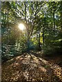
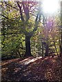
<< Our Photo Pages >> Ecclesall Woods - Rock Art in England in Yorkshire (South)
Submitted by baz on Friday, 16 July 2010 Page Views: 25528
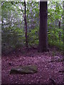
Rock ArtSite Name: Ecclesall WoodsCountry: England County: Yorkshire (South) Type: Rock Art
Nearest Town: Sheffield
Map Ref: SK326831
Latitude: 53.343798N Longitude: 1.51181W
Condition:
| 5 | Perfect |
| 4 | Almost Perfect |
| 3 | Reasonable but with some damage |
| 2 | Ruined but still recognisable as an ancient site |
| 1 | Pretty much destroyed, possibly visible as crop marks |
| 0 | No data. |
| -1 | Completely destroyed |
| 5 | Superb |
| 4 | Good |
| 3 | Ordinary |
| 2 | Not Good |
| 1 | Awful |
| 0 | No data. |
| 5 | Can be driven to, probably with disabled access |
| 4 | Short walk on a footpath |
| 3 | Requiring a bit more of a walk |
| 2 | A long walk |
| 1 | In the middle of nowhere, a nightmare to find |
| 0 | No data. |
| 5 | co-ordinates taken by GPS or official recorded co-ordinates |
| 4 | co-ordinates scaled from a detailed map |
| 3 | co-ordinates scaled from a bad map |
| 2 | co-ordinates of the nearest village |
| 1 | co-ordinates of the nearest town |
| 0 | no data |
Internal Links:
External Links:
I have visited· I would like to visit
johnwhitehead macfarlanep would like to visit
a60wattfish visited on 1st Jan 2024 - their rating: Cond: 3 Amb: 4 Access: 3 Easy to find off the footpath, in a nice clearing. Surprising it’s not more well known.
markp1999 visited on 23rd Sep 2022 - their rating: Cond: 4 Amb: 5 Access: 3
stretchyboy visited on 1st Aug 2020 - their rating: Cond: 4 Amb: 4 Access: 4
MartinRS have visited here
Average ratings for this site from all visit loggers: Condition: 3.67 Ambience: 4.33 Access: 3.33
")
An extract from the monuments description in the S.M.R.:
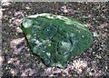
"The carving on the slightly domed upper surface of the rock consists of three sub-oval, deeply cut rings, each surrounding one to four shallower cups connected by gutters. The central ring with its internal cups has been emphasised by cutting away the sandstone on three sides to form a raised oval boss. This feature is possibly unique and illustrates that the carving was designed with visual prominence in mind rather than being executed purely as a ceremonial act. Other unusual features of the carving are the gutters near the edge of the slab which surround much of the carving. Internal gutters subdivide the slab into several irregular, enclosure-like, zones. The various elements of the carving are not cut to a consistent depth, frequently shallow features being intersected by deeper ones. This feature indicates that the carving was not executed as a unitary design but has been modified over time. There are several irregular patches of shallow carving on the slab which may represent attempts to cut away obtrusive features of earlier designs. Elsewhere on the slab they serve to emphasise particular features."
Note: Second example of prehistoric rock art found in park.
You may be viewing yesterday's version of this page. To see the most up to date information please register for a free account.
")
")
")
")
Do not use the above information on other web sites or publications without permission of the contributor.
Nearby Images from Geograph Britain and Ireland:
©2022(licence)
©2022(licence)
©2018(licence)
©2018(licence)
©2013(licence)
The above images may not be of the site on this page, they are loaded from Geograph.
Please Submit an Image of this site or go out and take one for us!
Click here to see more info for this site
Nearby sites
Key: Red: member's photo, Blue: 3rd party photo, Yellow: other image, Green: no photo - please go there and take one, Grey: site destroyed
Download sites to:
KML (Google Earth)
GPX (GPS waypoints)
CSV (Garmin/Navman)
CSV (Excel)
To unlock full downloads you need to sign up as a Contributory Member. Otherwise downloads are limited to 50 sites.
Turn off the page maps and other distractions
Nearby sites listing. In the following links * = Image available
2.6km SW 220° Peace Well* Holy Well or Sacred Spring (SK3093881126)
3.9km WSW 244° Giant's Chair (Yorkshire)* Standing Stone (Menhir) (SK291814)
4.4km NNE 18° Weston Park Museum* Museum (SK3389487292)
4.4km WSW 257° God's Spring* Holy Well or Sacred Spring (SK283821)
4.4km W 261° Harrys Stone* Ancient Temple (SK282824)
5.0km SW 231° Strawberry Lea* Ring Cairn (SK287799)
5.5km SSE 151° St John's Well (Dronfield) Holy Well or Sacred Spring (SK353783)
5.6km WSW 246° Ciceley Low I* Ring Cairn (SK2752080782)
5.6km WSW 246° Ciceley Low II* Ring Cairn (SK2752080782)
5.6km SW 223° Brown Edge* Stone Circle (SK288790)
5.7km WSW 248° Fingerem Stone* Cairn (SK273809)
6.2km SW 215° Owler Bar Cairn (SK291780)
6.4km WNW 301° Ash Cabin Fort* Hillfort (SK271864)
6.5km WNW 300° Ash Cabin Flat* Stone Circle (SK2693186251)
6.5km WNW 301° Ash Cabin standing stone* Standing Stone (Menhir) (SK270864)
6.8km WSW 257° Carl Wark* Hillfort (SK260815)
7.0km WSW 239° Little John's Well (Hathersage)* Holy Well or Sacred Spring (SK266794)
7.2km SW 217° Barbrook 3* Stone Circle (SK28337728)
7.2km WSW 253° Hathersage Moor Ring Cairn (SK257809)
7.2km WSW 250° Toads Mouth (Hathersage)* Natural Stone / Erratic / Other Natural Feature (SK258806)
7.4km WNW 301° Reddicar Clough (Hallam Moor) Cairn (SK26248688)
7.5km WSW 257° Winyards Nick* Round Barrow(s) (SK253813)
7.6km N 350° Wadsley Common* Stone Circle (SK312906)
7.6km NE 43° Darnall Common* Modern Stone Circle etc (SK378887)
7.8km WNW 301° New Hagg (Hallam Moors)* Standing Stone (Menhir) (SK2581587058)
View more nearby sites and additional images


 We would like to know more about this location. Please feel free to add a brief description and any relevant information in your own language.
 Wir möchten mehr über diese Stätte erfahren. Bitte zögern Sie nicht, eine kurze Beschreibung und relevante Informationen in Deutsch hinzuzufügen.
 Nous aimerions en savoir encore un peu sur les lieux. S'il vous plaît n'hesitez pas à ajouter une courte description et tous les renseignements pertinents dans votre propre langue.
 Quisieramos informarnos un poco más de las lugares. No dude en añadir una breve descripción y otros datos relevantes en su propio idioma.