<< Our Photo Pages >> Lad Barrow - Chambered Tomb in England in Gloucestershire
Submitted by vicky on Tuesday, 24 September 2002 Page Views: 6240
Neolithic and Bronze AgeSite Name: Lad Barrow Alternative Name: Aldsworth ICountry: England County: Gloucestershire Type: Chambered Tomb
Map Ref: SP166097 Landranger Map Number: 163
Latitude: 51.785717N Longitude: 1.760752W
Condition:
| 5 | Perfect |
| 4 | Almost Perfect |
| 3 | Reasonable but with some damage |
| 2 | Ruined but still recognisable as an ancient site |
| 1 | Pretty much destroyed, possibly visible as crop marks |
| 0 | No data. |
| -1 | Completely destroyed |
| 5 | Superb |
| 4 | Good |
| 3 | Ordinary |
| 2 | Not Good |
| 1 | Awful |
| 0 | No data. |
| 5 | Can be driven to, probably with disabled access |
| 4 | Short walk on a footpath |
| 3 | Requiring a bit more of a walk |
| 2 | A long walk |
| 1 | In the middle of nowhere, a nightmare to find |
| 0 | No data. |
| 5 | co-ordinates taken by GPS or official recorded co-ordinates |
| 4 | co-ordinates scaled from a detailed map |
| 3 | co-ordinates scaled from a bad map |
| 2 | co-ordinates of the nearest village |
| 1 | co-ordinates of the nearest town |
| 0 | no data |
Internal Links:
External Links:
I have visited· I would like to visit
4clydesdale7 visited on 14th Jan 2012 - their rating: Cond: 3 Amb: 4 Access: 4 Nice spot - avoid shooting days and low-flying partridge
")
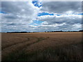
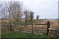
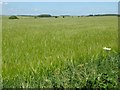
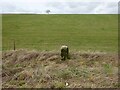
This mound has been badly damaged by ploughing. Two possible stones from the burial chamber lie at the eastern end.
From 4clydesdale7: A pleasantly sited Neolithic Chambered Tomb Long Barrow which has been damaged (but not too severely) over time by the plough. Orientated E/W it is 40m by 30m and about 0.8m high with two stones protruding on the E side.
Reported in the County of Gloucester Gazetteer by Daniel/Corcoran/Darvill/Grinsell as GLO66 but unusually ignored by George Witts 1883 who seemed to miss a lot near the Glos/Oxon borders. Well reported by BGAS 1960 Vol.79 p 69 and pastscape 329667 Gloucestershire; Cotswolds; Aldsworth.
Easy to visit and so worth a trip (Windrush Camp also close-by).
You may be viewing yesterday's version of this page. To see the most up to date information please register for a free account.
")
")
Do not use the above information on other web sites or publications without permission of the contributor.
davidmorgan has found this location on Google Street View:
Nearby Images from Geograph Britain and Ireland:
©2020(licence)
©2006(licence)
©2019(licence)
©2017(licence)
©2022(licence)
The above images may not be of the site on this page, they are loaded from Geograph.
Please Submit an Image of this site or go out and take one for us!
Click here to see more info for this site
Nearby sites
Key: Red: member's photo, Blue: 3rd party photo, Yellow: other image, Green: no photo - please go there and take one, Grey: site destroyed
Download sites to:
KML (Google Earth)
GPX (GPS waypoints)
CSV (Garmin/Navman)
CSV (Excel)
To unlock full downloads you need to sign up as a Contributory Member. Otherwise downloads are limited to 50 sites.
Turn off the page maps and other distractions
Nearby sites listing. In the following links * = Image available
1.0km S 184° Ladborough Camp* Hillfort (SP16540870)
3.0km NNE 30° Windrush Camp* Hillfort (SP181123)
3.7km NW 321° Lodge Park* Long Barrow (SP1426712550)
5.1km W 263° Saltway Barn Chambered Cairn (SP115091)
5.5km S 185° Barrow Elm* Round Barrow(s) (SP16110420)
5.7km W 266° Ablington Long Barrow Chambered Tomb (SP10910925)
5.8km W 267° Lamborough Banks* Chambered Cairn (SP10760942)
6.5km WSW 249° Ablington Camp* Hillfort (SP105074)
6.8km WNW 288° Crickley Barrow Chambered Tomb (SP101118)
7.1km NNW 328° Norbury Hillfort (Farmington)* Hillfort (SP128157)
7.2km NW 324° Norbury Hillfort Barrow* Chambered Tomb (SP124155)
8.2km NNW 327° Leygore Manor II* Chambered Tomb (SP121166)
8.4km NW 326° Leygore Manor* Chambered Tomb (SP1178816648)
8.9km NW 316° Burn Ground* Chambered Cairn (SP104161)
9.6km NW 305° Hangman's Stone (Northleach)* Standing Stone (Menhir) (SP087151)
9.9km W 263° Colnpen* Chambered Tomb (SP068084)
10.1km NW 308° Furzenhill Barn* Chambered Tomb (SP086159)
10.2km WNW 285° Woodbarrow (Glos)* Chambered Tomb (SP06731228)
10.2km WNW 285° Royal Oak* Round Barrow(s) (SP06701239)
10.3km SSE 154° Lechlade Cursus Cursus (SP212005)
10.3km NW 309° Cheltenham Road Plantation* Chambered Cairn (SP085161)
10.3km SSE 154° Lechlade Cursus Cursus (SP21240048)
10.5km NNE 30° Fifield Chambered Cairn (SP218188)
10.6km SSE 153° Lechlade Cursus Cursus (SP214002)
11.1km N 5° Salmonsbury Camp* Hillfort (SP175208)
View more nearby sites and additional images


 We would like to know more about this location. Please feel free to add a brief description and any relevant information in your own language.
 Wir möchten mehr über diese Stätte erfahren. Bitte zögern Sie nicht, eine kurze Beschreibung und relevante Informationen in Deutsch hinzuzufügen.
 Nous aimerions en savoir encore un peu sur les lieux. S'il vous plaît n'hesitez pas à ajouter une courte description et tous les renseignements pertinents dans votre propre langue.
 Quisieramos informarnos un poco más de las lugares. No dude en añadir una breve descripción y otros datos relevantes en su propio idioma.