<< Our Photo Pages >> Pateley Moor - Standing Stone (Menhir) in England in Yorkshire (North)
Submitted by PeterCrump on Sunday, 14 December 2003 Page Views: 9508
Neolithic and Bronze AgeSite Name: Pateley MoorCountry: England
NOTE: This site is 3.7 km away from the location you searched for.
County: Yorkshire (North) Type: Standing Stone (Menhir)
Nearest Town: Ripon Nearest Village: Pateley Bridge
Map Ref: SE193695 Landranger Map Number: 99
Latitude: 54.121006N Longitude: 1.706212W
Condition:
| 5 | Perfect |
| 4 | Almost Perfect |
| 3 | Reasonable but with some damage |
| 2 | Ruined but still recognisable as an ancient site |
| 1 | Pretty much destroyed, possibly visible as crop marks |
| 0 | No data. |
| -1 | Completely destroyed |
| 5 | Superb |
| 4 | Good |
| 3 | Ordinary |
| 2 | Not Good |
| 1 | Awful |
| 0 | No data. |
| 5 | Can be driven to, probably with disabled access |
| 4 | Short walk on a footpath |
| 3 | Requiring a bit more of a walk |
| 2 | A long walk |
| 1 | In the middle of nowhere, a nightmare to find |
| 0 | No data. |
| 5 | co-ordinates taken by GPS or official recorded co-ordinates |
| 4 | co-ordinates scaled from a detailed map |
| 3 | co-ordinates scaled from a bad map |
| 2 | co-ordinates of the nearest village |
| 1 | co-ordinates of the nearest town |
| 0 | no data |
Internal Links:
External Links:
")
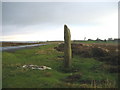
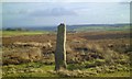
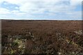
This single standing stone lies on Pateley Moor in North Yorkshire (Landranger ref SE193695 approx). Its provenance is unknown, possibly modern?
You may be viewing yesterday's version of this page. To see the most up to date information please register for a free account.
")
")
Do not use the above information on other web sites or publications without permission of the contributor.
Runemage has found this location on Google Street View:
Nearby Images from Geograph Britain and Ireland:
©2006(licence)
©2014(licence)
©2021(licence)
©2005(licence)
©2021(licence)
The above images may not be of the site on this page, they are loaded from Geograph.
Please Submit an Image of this site or go out and take one for us!
Click here to see more info for this site
Nearby sites
Key: Red: member's photo, Blue: 3rd party photo, Yellow: other image, Green: no photo - please go there and take one, Grey: site destroyed
Download sites to:
KML (Google Earth)
GPX (GPS waypoints)
CSV (Garmin/Navman)
CSV (Excel)
To unlock full downloads you need to sign up as a Contributory Member. Otherwise downloads are limited to 50 sites.
Turn off the page maps and other distractions
Nearby sites listing. In the following links * = Image available
2.2km NNE 29° Cast Hills* Ancient Village or Settlement (SE20377147)
2.4km N 357° Hell Holme Bank (Dallowgill) Rock Art (SE1917071909)
3.9km NNW 339° Fortress Dyke camp* Ancient Village or Settlement (SE1789173178)
4.4km ESE 118° Wine Wife Well* Holy Well or Sacred Spring (SE23216742)
4.6km SSE 164° Brimham Rocks Circle Stone Circle (SE20566507)
4.8km SSE 167° Brimham Rocks Rock Art Rock Art (SE2039764782)
4.9km SSE 160° Brimham Rocks* Rock Outcrop (SE210649)
5.0km NNW 341° Carle Tower* Marker Stone (SE177742)
5.6km SSE 162° Graffa Plain (Hartwith) Cairn (SE211642)
6.6km SSW 206° Guisecliff Wood (629)* Rock Art (SE1641563565)
6.7km SSW 209° Guisecliff Wood (626)* Rock Art (SE1607863641)
7.0km SSW 206° Hayshaw Moor North (Dacre) Cairn (SE1621863253)
7.0km SSE 164° Hartwith Moor* Standing Stone (Menhir) (SE2123362737)
7.2km W 266° Gouthwaite Lodge Farm 03* Rock Art (SE1213568998)
7.2km W 266° Gouthwaite Lodge Farm 02* Rock Art (SE1213468996)
7.2km W 266° Gouthwaite Lodge Farm 01* Rock Art (SE1213168992)
7.2km S 185° Bryan's Wood 01 Rock Art (SE1866362280)
7.3km W 262° Gouthwaite Lodge Farm* Rock Art (SE121684)
7.3km S 186° Eastwoods Farm 01 (Heyshaw) Rock Art (SE1855662240)
7.3km S 186° Fertility Stone (CR-638)* Rock Art (SE1855262228)
7.4km S 186° Eastwoods Farm 02 (Heyshaw) Rock Art (SE1857262168)
7.4km NNE 26° Billey Keld* Holy Well or Sacred Spring (SE2251376193)
7.5km S 186° Eastwoods Cross Base (Summerbridge) Rock Art (SE1850662013)
7.5km S 186° Eastwoods Farm Cup (Heyshaw)* Rock Art (SE1852062010)
7.7km S 186° Morphing Stone (Dacre)* Rock Art (SE1855961795)
View more nearby sites and additional images


 We would like to know more about this location. Please feel free to add a brief description and any relevant information in your own language.
 Wir möchten mehr über diese Stätte erfahren. Bitte zögern Sie nicht, eine kurze Beschreibung und relevante Informationen in Deutsch hinzuzufügen.
 Nous aimerions en savoir encore un peu sur les lieux. S'il vous plaît n'hesitez pas à ajouter une courte description et tous les renseignements pertinents dans votre propre langue.
 Quisieramos informarnos un poco más de las lugares. No dude en añadir una breve descripción y otros datos relevantes en su propio idioma.