 with our Megalithic Portal iPhone app")


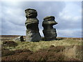
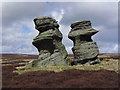
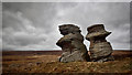
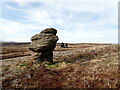
<< Our Photo Pages >> Jenny Twig and Tib - Rock Outcrop in England in Yorkshire (North)
Submitted by DavidRaven on Sunday, 14 December 2003 Page Views: 16978
Natural PlacesSite Name: Jenny Twig and TibCountry: England County: Yorkshire (North) Type: Rock Outcrop
Nearest Town: Ripon Nearest Village: Bouthwaite
Map Ref: SE129741 Landranger Map Number: 99
Latitude: 54.162547N Longitude: 1.803934W
Condition:
| 5 | Perfect |
| 4 | Almost Perfect |
| 3 | Reasonable but with some damage |
| 2 | Ruined but still recognisable as an ancient site |
| 1 | Pretty much destroyed, possibly visible as crop marks |
| 0 | No data. |
| -1 | Completely destroyed |
| 5 | Superb |
| 4 | Good |
| 3 | Ordinary |
| 2 | Not Good |
| 1 | Awful |
| 0 | No data. |
| 5 | Can be driven to, probably with disabled access |
| 4 | Short walk on a footpath |
| 3 | Requiring a bit more of a walk |
| 2 | A long walk |
| 1 | In the middle of nowhere, a nightmare to find |
| 0 | No data. |
| 5 | co-ordinates taken by GPS or official recorded co-ordinates |
| 4 | co-ordinates scaled from a detailed map |
| 3 | co-ordinates scaled from a bad map |
| 2 | co-ordinates of the nearest village |
| 1 | co-ordinates of the nearest town |
| 0 | no data |
Internal Links:
External Links:
")
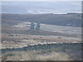
On the broad expanse of Fountains Earth Moor can be found the towering stone stacks of Jenny Twig and her daughter Tib. They stand together, set apart from the neighbouring outcrop of Millstone Grit called Sypeland Crags. Nobody local knows the origin of the names. One writer noted the similarity to the Gaelic 'Tuig', 'to be wise'. In 1863, William Graing rather romantically referred to them as 'Giantesses in broad bonnetts'. It's easy to believe this when you spend any time here. The moorland hereabouts is trackless, remote, scattered with bogs and eerie rock features.
You may be viewing yesterday's version of this page. To see the most up to date information please register for a free account.
")
Do not use the above information on other web sites or publications without permission of the contributor.
Nearby Images from Geograph Britain and Ireland:
©2018(licence)
©2013(licence)
©2019(licence)
©2021(licence)
©2007(licence)
The above images may not be of the site on this page, they are loaded from Geograph.
Please Submit an Image of this site or go out and take one for us!
Click here to see more info for this site
Nearby sites
Key: Red: member's photo, Blue: 3rd party photo, Yellow: other image, Green: no photo - please go there and take one, Grey: site destroyed
Download sites to:
KML (Google Earth)
GPX (GPS waypoints)
CSV (Garmin/Navman)
CSV (Excel)
To unlock full downloads you need to sign up as a Contributory Member. Otherwise downloads are limited to 50 sites.
Turn off the page maps and other distractions
Nearby sites listing. In the following links * = Image available
1.9km SSW 212° Fountains Earth 01 Rock Art (SE1188572499)
3.6km W 271° St Chad (Middlesmoor)* Ancient Cross (SE09257414)
4.8km E 89° Carle Tower* Marker Stone (SE177742)
5.1km E 101° Fortress Dyke camp* Ancient Village or Settlement (SE1789173178)
5.2km S 189° Gouthwaite Lodge Farm 03* Rock Art (SE1213568998)
5.2km S 189° Gouthwaite Lodge Farm 02* Rock Art (SE1213468996)
5.2km S 189° Gouthwaite Lodge Farm 01* Rock Art (SE1213168992)
5.8km S 188° Gouthwaite Lodge Farm* Rock Art (SE121684)
6.5km NE 45° Swinton Druid's Temple* Modern Stone Circle etc (SE1746478713)
6.6km ESE 109° Hell Holme Bank (Dallowgill) Rock Art (SE1917071909)
7.1km NE 56° Skew Skell Well* Holy Well or Sacred Spring (SE1876078084)
7.6km N 9° West Agra Carving 1 Rock Art (SE1406981627)
7.7km N 9° West Agra Carving 2b Rock Art (SE1412681669)
7.7km N 10° West Agra 3a and 3b* Rock Art (SE1423681675)
7.8km N 10° West Agra* Rock Art (SE14248175)
7.9km NNE 15° Gollinglith Foot (West Agra) Standing Stone (Menhir) (SE149817)
7.9km SE 126° Pateley Moor* Standing Stone (Menhir) (SE193695)
7.9km ESE 110° Cast Hills* Ancient Village or Settlement (SE20377147)
8.0km NNE 31° Healey Stone Circles (Masham) Stone Circle (SE170810)
8.2km NE 46° Fearby, Masham* Stone Circle (SE188798)
8.4km N 4° Agra Moor Standing Stone* Standing Stone (Menhir) (SE1349982440)
9.1km ENE 69° Himalayan Gardens & Sculpture Park* Modern Stone Circle etc (SE2139577417)
9.6km ENE 73° Lime Tree Modern Stone Circle* Modern Stone Circle etc (SE2212876922)
9.6km ENE 74° Lime Tree Roundhouse* Modern Stone Circle etc (SE2216776849)
9.8km ENE 78° Billey Keld* Holy Well or Sacred Spring (SE2251376193)
View more nearby sites and additional images


 We would like to know more about this location. Please feel free to add a brief description and any relevant information in your own language.
 Wir möchten mehr über diese Stätte erfahren. Bitte zögern Sie nicht, eine kurze Beschreibung und relevante Informationen in Deutsch hinzuzufügen.
 Nous aimerions en savoir encore un peu sur les lieux. S'il vous plaît n'hesitez pas à ajouter une courte description et tous les renseignements pertinents dans votre propre langue.
 Quisieramos informarnos un poco más de las lugares. No dude en añadir una breve descripción y otros datos relevantes en su propio idioma.