


<< Our Photo Pages >> Piggle Dene - Natural Stone / Erratic / Other Natural Feature in England in Wiltshire
Submitted by tjhavenith on Thursday, 17 August 2017 Page Views: 4134
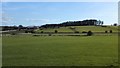
Natural PlacesSite Name: Piggle Dene Alternative Name: PiggledeneCountry: England County: Wiltshire Type: Natural Stone / Erratic / Other Natural Feature
Nearest Town: Marlborough Nearest Village: Fyfield
Map Ref: SU14126858
Latitude: 51.416064N Longitude: 1.798347W
Condition:
| 5 | Perfect |
| 4 | Almost Perfect |
| 3 | Reasonable but with some damage |
| 2 | Ruined but still recognisable as an ancient site |
| 1 | Pretty much destroyed, possibly visible as crop marks |
| 0 | No data. |
| -1 | Completely destroyed |
| 5 | Superb |
| 4 | Good |
| 3 | Ordinary |
| 2 | Not Good |
| 1 | Awful |
| 0 | No data. |
| 5 | Can be driven to, probably with disabled access |
| 4 | Short walk on a footpath |
| 3 | Requiring a bit more of a walk |
| 2 | A long walk |
| 1 | In the middle of nowhere, a nightmare to find |
| 0 | No data. |
| 5 | co-ordinates taken by GPS or official recorded co-ordinates |
| 4 | co-ordinates scaled from a detailed map |
| 3 | co-ordinates scaled from a bad map |
| 2 | co-ordinates of the nearest village |
| 1 | co-ordinates of the nearest town |
| 0 | no data |
Internal Links:
External Links:
I have visited· I would like to visit
Humbucker has visited here
")
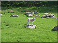
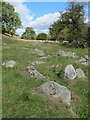
This is because Fyfield down, of which Piggle Dene is part, is home to an assemblage of many thousand sarsen stones, often called grey wethers as from a distance people have mistaken them for sheep. This whole area was made by natural forces which were not only strong enough to shape this landscape, but also to carry the stones to where they lie.
The stones seem to lay in a 'train' or 'boulder stream' and were transported and dropped into position via a process of freezing and thawing.
Sarsen stones are composed of sand particles that have cemented together over time to form a very hard sandstone. Amazingly, the roots of tropical plants can be seen in some stones. These root holes were made 50 million years ago, when the stones were still sandy soil. The cementation of the sediments happened about 5-10 million years ago just below the surface of the ground (at the time). The uncemented sediments have long since washed away. You can see sarsen stones in use at important sites such as Avebury and Stone Henge.
To save Piggledene and Locheridge Dene from being broken up for use in pavements, the National Trust along with Marlborough College Natural History Society and the Wiltshire Archaeological Society launched an appeal in 1907 to raise funds to purchase these sites. Having raised £612, the National Trust purchased the sites in 1908 [1][2].
Access
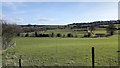
Access is over a stile on the edge of the busy and fast A4. I would suggest parking on one of the side roads, Church Hill is to the east and High Street is to the west (and has a bus stop a few metres in from the A4). There is a path to the side of the road heading west.
Accessibility
The A4 is a busy road and the path that leads to the site is narrow and not kept very well. At the entrance to the site, there is a stile to get over - there is a gate next to it, but I am not sure if this can be opened. Once you get into the site, the field is grassy and uneven - with the grass only kept short by the sheep.
[1] National Trust
[2] Wiltshire archaeological and natural history magazine
You may be viewing yesterday's version of this page. To see the most up to date information please register for a free account.
")
")
")
")
Do not use the above information on other web sites or publications without permission of the contributor.
Nearby Images from Geograph Britain and Ireland:
©2007(licence)
©2016(licence)
©2022(licence)
©2019(licence)
©2016(licence)
The above images may not be of the site on this page, they are loaded from Geograph.
Please Submit an Image of this site or go out and take one for us!
Click here to see more info for this site
Nearby sites
Key: Red: member's photo, Blue: 3rd party photo, Yellow: other image, Green: no photo - please go there and take one, Grey: site destroyed
Download sites to:
KML (Google Earth)
GPX (GPS waypoints)
CSV (Garmin/Navman)
CSV (Excel)
To unlock full downloads you need to sign up as a Contributory Member. Otherwise downloads are limited to 50 sites.
Turn off the page maps and other distractions
Nearby sites listing. In the following links * = Image available
1.1km SSW 201° West Overton Bowl Barrow Round Barrow(s) (SU13736758)
1.3km S 172° Lockeridge Grey Wethers* Natural Stone / Erratic / Other Natural Feature (SU143673)
1.5km NW 308° Down Barn* Standing Stones (SU12966949)
1.5km NE 46° Devils Den* Burial Chamber or Dolmen (SU1521169654)
1.6km NW 325° Pickledean Stone Circle (SU13196988)
2.0km E 92° Broadstones* Stone Circle (SU161685)
2.0km NNW 348° Mother's Jam* Natural Stone / Erratic / Other Natural Feature (SU13697052)
2.0km ENE 78° Broad Stones (Clatford) Stone Circle (SU16096900)
2.1km NNW 343° The Toad Stone* Natural Stone / Erratic / Other Natural Feature (SU135706)
2.2km W 259° The Sanctuary Barrows* Barrow Cemetery (SU11966816)
2.2km NNW 331° Overton Downs Tumuli* Round Barrow(s) (SU13057051)
2.3km SSE 164° West Woods Polissoir No.1* Polissoir (SU1476966380)
2.3km WSW 255° Bowl Barrow SE of the Sanctuary Barrow Cemetery (SU11896797)
2.4km WSW 256° The Sanctuary.* Stone Circle (SU11836802)
2.4km WSW 255° Bowl Barrow South of the Sanctuary* Barrow Cemetery (SU11836794)
2.4km N 2° Fyfield Down* Ancient Village or Settlement (SU142710)
2.4km ENE 78° Manton Round Barrow* Round Barrow(s) (SU165691)
2.5km WSW 236° East Kennett garden feature* Modern Stone Circle etc (SU12066720)
2.5km NNW 331° Overton Down second polisher* Polissoir (SU1290170736)
2.6km SSE 155° West Woods (Hursley Bottom) Standing Stone* Standing Stone (Menhir) (SU15226625)
2.6km W 271° Overton Hill barrow cemetery* Barrow Cemetery (SU11526863)
2.6km S 172° West Woods Sarsen Stones* Natural Stone / Erratic / Other Natural Feature (SU145660)
2.7km WNW 304° Avebury Down barrow cemetery* Barrow Cemetery (SU11877007)
2.7km N 6° Long Tom (Avebury)* Standing Stone (Menhir) (SU1438371290)
2.8km WSW 252° Stone pair between Kennetts* Natural Stone / Erratic / Other Natural Feature (SU115677)
View more nearby sites and additional images


 We would like to know more about this location. Please feel free to add a brief description and any relevant information in your own language.
 Wir möchten mehr über diese Stätte erfahren. Bitte zögern Sie nicht, eine kurze Beschreibung und relevante Informationen in Deutsch hinzuzufügen.
 Nous aimerions en savoir encore un peu sur les lieux. S'il vous plaît n'hesitez pas à ajouter une courte description et tous les renseignements pertinents dans votre propre langue.
 Quisieramos informarnos un poco más de las lugares. No dude en añadir una breve descripción y otros datos relevantes en su propio idioma.