<< Our Photo Pages >> Lanshaw Lass - Standing Stone (Menhir) in England in Yorkshire (West)
Submitted by andy_h on Sunday, 14 December 2003 Page Views: 8850
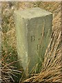
Neolithic and Bronze AgeSite Name: Lanshaw LassCountry: England County: Yorkshire (West) Type: Standing Stone (Menhir)
Nearest Town: Ilkley
Map Ref: SE13204545 Landranger Map Number: 104
Latitude: 53.905046N Longitude: 1.800574W
Condition:
| 5 | Perfect |
| 4 | Almost Perfect |
| 3 | Reasonable but with some damage |
| 2 | Ruined but still recognisable as an ancient site |
| 1 | Pretty much destroyed, possibly visible as crop marks |
| 0 | No data. |
| -1 | Completely destroyed |
| 5 | Superb |
| 4 | Good |
| 3 | Ordinary |
| 2 | Not Good |
| 1 | Awful |
| 0 | No data. |
| 5 | Can be driven to, probably with disabled access |
| 4 | Short walk on a footpath |
| 3 | Requiring a bit more of a walk |
| 2 | A long walk |
| 1 | In the middle of nowhere, a nightmare to find |
| 0 | No data. |
| 5 | co-ordinates taken by GPS or official recorded co-ordinates |
| 4 | co-ordinates scaled from a detailed map |
| 3 | co-ordinates scaled from a bad map |
| 2 | co-ordinates of the nearest village |
| 1 | co-ordinates of the nearest town |
| 0 | no data |
Internal Links:
External Links:
")
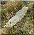
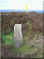
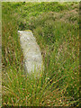
Although this fallen boundary stone is thought to be Saxon in origin, I've included it here for the reason that it occupies the centre point of the long edge of the isosceles triangle formed by the Backstone Circle, Twelve Apostles and the Grubstones and maybe a replacement for an earlier standing stone in this spot. There are also hints of being a sunrise marker. SE1320 4545
You may be viewing yesterday's version of this page. To see the most up to date information please register for a free account.
")
Do not use the above information on other web sites or publications without permission of the contributor.
Nearby Images from Geograph Britain and Ireland:
©2019(licence)
©2023(licence)
©2024(licence)
©2014(licence)
©2019(licence)
The above images may not be of the site on this page, they are loaded from Geograph.
Please Submit an Image of this site or go out and take one for us!
Click here to see more info for this site
Nearby sites
Key: Red: member's photo, Blue: 3rd party photo, Yellow: other image, Green: no photo - please go there and take one, Grey: site destroyed
Download sites to:
KML (Google Earth)
GPX (GPS waypoints)
CSV (Garmin/Navman)
CSV (Excel)
To unlock full downloads you need to sign up as a Contributory Member. Otherwise downloads are limited to 50 sites.
Turn off the page maps and other distractions
Nearby sites listing. In the following links * = Image available
62m WNW 291° Lanshaw Delves 05* Rock Art (SE1314245472)
80m WNW 302° Lanshaw Delves 04* Rock Art (SE1313245492)
119m WSW 248° Lanshaw Delves 02* Rock Art (SE1308945406)
227m NNW 338° Lanshaw Delves 03* Rock Art (SE1311545661)
234m ESE 105° Lanshaw 01* Rock Art (SE1342745390)
240m E 97° Lanshaw 02* Rock Art (SE1343945421)
244m E 92° Lanshaw 09* Rock Art (SE1344545444)
269m E 99° Lanshaw 04* Rock Art (SE1346645407)
269m NNW 338° Green Crag Plain (Ilkley Moor) Standing Stone (Menhir) (SE131457)
277m ESE 108° Lanshaw 03 Rock Art (SE1346545366)
278m ESE 105° Lanshaw Rock Art (SE13474538)
279m ESE 104° Lanshaw 06* Rock Art (SE1347145382)
280m W 265° Lanshaw Delves 01* Rock Art (SE1292045423)
283m ESE 107° Lanshaw 05* Rock Art (SE1347145366)
283m ESE 107° Lanshaw 07* Rock Art (SE1347245369)
287m E 81° Lanshaw 08* Rock Art (SE1348445495)
302m E 95° Lanshaw 10* Rock Art (SE1350245424)
306m E 94° Lanshaw 11* Rock Art (SE1350645428)
339m ENE 60° Green Crag 15* Rock Art (SE1349345623)
344m E 100° Lanshaw 12* Rock Art (SE1354045390)
364m NNW 344° Green Crag Top (Ilkley Moor) Cairn (SE131458)
388m ENE 64° Green Crag 18 Rock Art (SE1355045620)
412m NNW 345° Green Crag 12.* Rock Art (SE1309045847)
414m NNE 15° Green Crag Slack 10* Rock Art (SE1330845850)
433m NE 46° Green Crag 16* Rock Art (SE1351445750)
View more nearby sites and additional images


 We would like to know more about this location. Please feel free to add a brief description and any relevant information in your own language.
 Wir möchten mehr über diese Stätte erfahren. Bitte zögern Sie nicht, eine kurze Beschreibung und relevante Informationen in Deutsch hinzuzufügen.
 Nous aimerions en savoir encore un peu sur les lieux. S'il vous plaît n'hesitez pas à ajouter une courte description et tous les renseignements pertinents dans votre propre langue.
 Quisieramos informarnos un poco más de las lugares. No dude en añadir una breve descripción y otros datos relevantes en su propio idioma.