 with our Megalithic Portal iPhone app")

<< Our Photo Pages >> Cowper's Cross (Ilkley Moor) - Ancient Cross in England in Yorkshire (West)
Submitted by Anne T on Thursday, 13 July 2017 Page Views: 5344
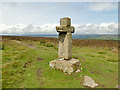
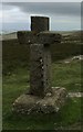
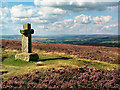
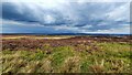
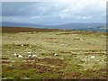
Early MedievalSite Name: Cowper's Cross (Ilkley Moor) Alternative Name: Cawper's Cross (Ilkley Moor)Country: England County: Yorkshire (West) Type: Ancient Cross
Nearest Town: Ilkley
Map Ref: SE1022345609
Latitude: 53.906541N Longitude: 1.84588W
Condition:
| 5 | Perfect |
| 4 | Almost Perfect |
| 3 | Reasonable but with some damage |
| 2 | Ruined but still recognisable as an ancient site |
| 1 | Pretty much destroyed, possibly visible as crop marks |
| 0 | No data. |
| -1 | Completely destroyed |
| 5 | Superb |
| 4 | Good |
| 3 | Ordinary |
| 2 | Not Good |
| 1 | Awful |
| 0 | No data. |
| 5 | Can be driven to, probably with disabled access |
| 4 | Short walk on a footpath |
| 3 | Requiring a bit more of a walk |
| 2 | A long walk |
| 1 | In the middle of nowhere, a nightmare to find |
| 0 | No data. |
| 5 | co-ordinates taken by GPS or official recorded co-ordinates |
| 4 | co-ordinates scaled from a detailed map |
| 3 | co-ordinates scaled from a bad map |
| 2 | co-ordinates of the nearest village |
| 1 | co-ordinates of the nearest town |
| 0 | no data |
Be the first person to rate this site - see the 'Contribute!' box in the right hand menu.
Internal Links:
External Links:
I have visited· I would like to visit
ewmjc visited on 1st Jan 2018 - their rating: Cond: 4 Access: 4
 (PID:229452)")
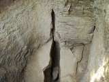
This cross, dated to possibly the 16th or 17th century and restored in the 19th is recorded as Pastscape Monument No. 49856. They add that the cross is complete, but mainly modern and badly restored; only the socket stone appears to be original.
Cowper's Cross also features on The Northern Antiquarian (TNA) - see their entry for Cowper’s Cross, Ilkley Moor, West Yorkshire which gives directions on how to find the cross, includes the location of the cross on the OS map of 1851 and the image of a 1920's postcard. In addition, they include some archaeology and history and some local folklore.
TNA adds that this site is on the way to the Badger Stone and is near the lesser-known Black Knoll Cross.
You may be viewing yesterday's version of this page. To see the most up to date information please register for a free account.
 (PID:230004)")
Do not use the above information on other web sites or publications without permission of the contributor.
Nearby Images from Geograph Britain and Ireland:
©2020(licence)
©2019(licence)
©2005(licence)
©2022(licence)
©2023(licence)
The above images may not be of the site on this page, they are loaded from Geograph.
Please Submit an Image of this site or go out and take one for us!
Click here to see more info for this site
Nearby sites
Key: Red: member's photo, Blue: 3rd party photo, Yellow: other image, Green: no photo - please go there and take one, Grey: site destroyed
Download sites to:
KML (Google Earth)
GPX (GPS waypoints)
CSV (Garmin/Navman)
CSV (Excel)
To unlock full downloads you need to sign up as a Contributory Member. Otherwise downloads are limited to 50 sites.
Turn off the page maps and other distractions
Nearby sites listing. In the following links * = Image available
250m SE 141° Whetstone Gate 02* Rock Art (SE1038045414)
277m SSE 168° Whetstone Gate 01* Rock Art (SE1027945338)
324m SE 135° Whetstone Gate 03* Rock Art (SE1045345380)
483m ENE 74° Green Gates 01a* Rock Art (SE1068845745)
751m NNE 31° Weary Hill 02* Rock Art (SE1061446251)
782m NNW 345° Coarse Stone Edge 01.* Rock Art (SE1001846364)
786m W 281° East Buck Stones 02* Rock Art (SE0944845751)
789m SSE 153° Two Eggs (N) 02* Rock Art (SE1057844904)
798m NNE 12° Coarse Stone Edge 04* Rock Art (SE1039046390)
798m NNE 12° Neb Stone* Rock Art (SE10394639)
801m SSE 154° Two Eggs (S) 01 Rock Art (SE1057244887)
804m NNE 12° Coarse Stone Edge 03* Rock Art (SE1039246396)
806m NNE 26° Weary Hill 01* Rock Art (SE1057246336)
808m N 11° Coarse Stone Edge 01a* Rock Art (SE1036946404)
808m SE 125° Thimble Stones 01* Rock Art (SE1089045150)
827m NNE 12° Coarse Stone Edge 02a* Rock Art (SE1039246419)
869m WNW 286° East Buck Stones 01* Rock Art (SE0938645853)
893m N 356° Course Stone Edge Ark* Rock Art (SE10164650)
956m ENE 63° Badger Stone* Rock Art (SE1107446050)
970m N 2° Silver Well 01* Rock Art (SE1025246579)
971m N 349° Black Beck Hole 04* Rock Art (SE1003746563)
975m S 173° Black Knowle (Morton Moor)* Ancient Cross (SE10344464)
990m N 350° Black Beck Hole 05* Rock Art (SE1005646585)
1.0km ENE 60° Green Gates 01.* Rock Art (SE1110546127)
1.0km NNW 332° Black Beck Hole 01* Rock Art (SE0973246521)
View more nearby sites and additional images


 We would like to know more about this location. Please feel free to add a brief description and any relevant information in your own language.
 Wir möchten mehr über diese Stätte erfahren. Bitte zögern Sie nicht, eine kurze Beschreibung und relevante Informationen in Deutsch hinzuzufügen.
 Nous aimerions en savoir encore un peu sur les lieux. S'il vous plaît n'hesitez pas à ajouter une courte description et tous les renseignements pertinents dans votre propre langue.
 Quisieramos informarnos un poco más de las lugares. No dude en añadir una breve descripción y otros datos relevantes en su propio idioma.