

<< Our Photo Pages >> East Buck Stones 02 - Rock Art in England in Yorkshire (West)
Submitted by Anne T on Wednesday, 31 January 2018 Page Views: 1157
Rock ArtSite Name: East Buck Stones 02 Alternative Name: ERA-2501; PRN9319Country: England
NOTE: This site is 0.3 km away from the location you searched for.
County: Yorkshire (West) Type: Rock Art
Nearest Town: Ilkley / Keighley
Map Ref: SE0944845751
Latitude: 53.907832N Longitude: 1.857672W
Condition:
| 5 | Perfect |
| 4 | Almost Perfect |
| 3 | Reasonable but with some damage |
| 2 | Ruined but still recognisable as an ancient site |
| 1 | Pretty much destroyed, possibly visible as crop marks |
| 0 | No data. |
| -1 | Completely destroyed |
| 5 | Superb |
| 4 | Good |
| 3 | Ordinary |
| 2 | Not Good |
| 1 | Awful |
| 0 | No data. |
| 5 | Can be driven to, probably with disabled access |
| 4 | Short walk on a footpath |
| 3 | Requiring a bit more of a walk |
| 2 | A long walk |
| 1 | In the middle of nowhere, a nightmare to find |
| 0 | No data. |
| 5 | co-ordinates taken by GPS or official recorded co-ordinates |
| 4 | co-ordinates scaled from a detailed map |
| 3 | co-ordinates scaled from a bad map |
| 2 | co-ordinates of the nearest village |
| 1 | co-ordinates of the nearest town |
| 0 | no data |
Be the first person to rate this site - see the 'Contribute!' box in the right hand menu.
Internal Links:
External Links:
")
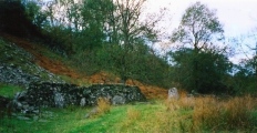
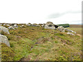
This rock art panel has probable carvings which are all located on its western sloping face. These carvings include two cups close together, and two more possible cups. For more information see England's Rock Art entry for ERA-2501 East Buck Stones 02, which includes a detailed description, photographs, a plan of the rock and its motifs, plus photogrammetry. ERA notes that there are other marks/carvings on the surface of this rock, but they are unlikely to be prehistoric.
This rock art panel is located on Open Access land.
Note: Have you seen this rock art panel? Do you have any photographs or information to add?
You may be viewing yesterday's version of this page. To see the most up to date information please register for a free account.
Do not use the above information on other web sites or publications without permission of the contributor.
Nearby Images from Geograph Britain and Ireland:
©2009(licence)

©2020(licence)
©2013(licence)
©2020(licence)
©2020(licence)
The above images may not be of the site on this page, they are loaded from Geograph.
Please Submit an Image of this site or go out and take one for us!
Click here to see more info for this site
Nearby sites
Key: Red: member's photo, Blue: 3rd party photo, Yellow: other image, Green: no photo - please go there and take one, Grey: site destroyed
Download sites to:
KML (Google Earth)
GPX (GPS waypoints)
CSV (Garmin/Navman)
CSV (Excel)
To unlock full downloads you need to sign up as a Contributory Member. Otherwise downloads are limited to 50 sites.
Turn off the page maps and other distractions
Nearby sites listing. In the following links * = Image available
119m NNW 329° East Buck Stones 01* Rock Art (SE0938645853)
786m E 101° Cowper's Cross (Ilkley Moor)* Ancient Cross (SE1022345609)
820m NNE 20° Black Beck Hole 01* Rock Art (SE0973246521)
836m NE 43° Coarse Stone Edge 01.* Rock Art (SE1001846364)
926m ESE 117° Whetstone Gate 01* Rock Art (SE1027945338)
988m ESE 110° Whetstone Gate 02* Rock Art (SE1038045414)
1.0km NE 36° Black Beck Hole 04* Rock Art (SE1003746563)
1.0km NE 36° Black Beck Hole 05* Rock Art (SE1005646585)
1.0km NE 44° Course Stone Edge Ark* Rock Art (SE10164650)
1.0km WSW 244° Bucking Hill 04 & 05 Rock Art (SE0851045300)
1.1km ESE 110° Whetstone Gate 03* Rock Art (SE1045345380)
1.1km SSW 210° Kirk Stones (Morton Moor) Natural Stone / Erratic / Other Natural Feature (SE089448)
1.1km WSW 245° Bucking Hill 03* Rock Art (SE0845045290)
1.1km NE 55° Coarse Stone Edge 01a* Rock Art (SE1036946404)
1.1km NE 56° Coarse Stone Edge 04* Rock Art (SE1039046390)
1.1km NE 56° Neb Stone* Rock Art (SE10394639)
1.1km NE 56° Coarse Stone Edge 03* Rock Art (SE1039246396)
1.2km NE 44° Silver Well 01* Rock Art (SE1025246579)
1.2km NE 55° Coarse Stone Edge 02a* Rock Art (SE1039246419)
1.2km WSW 239° Bucking Hill 02 Rock Art (SE0842045130)
1.2km NNW 341° High Crag 01 (Ilkley)* Rock Art (SE0904946899)
1.2km N 2° Woodhouse Crag 03* Rock Art (SE0949646967)
1.2km N 5° Swastika Stone 01* Rock Art (SE0955446968)
1.2km E 90° Green Gates 01a* Rock Art (SE1068845745)
1.2km NNE 20° Heber's Ghyll Chalybeate (Ilkley)* Holy Well or Sacred Spring (SE09884692)
View more nearby sites and additional images


 We would like to know more about this location. Please feel free to add a brief description and any relevant information in your own language.
 Wir möchten mehr über diese Stätte erfahren. Bitte zögern Sie nicht, eine kurze Beschreibung und relevante Informationen in Deutsch hinzuzufügen.
 Nous aimerions en savoir encore un peu sur les lieux. S'il vous plaît n'hesitez pas à ajouter une courte description et tous les renseignements pertinents dans votre propre langue.
 Quisieramos informarnos un poco más de las lugares. No dude en añadir una breve descripción y otros datos relevantes en su propio idioma.