


<< Other Photo Pages >> South Street Long Barrow - Chambered Tomb in England in Wiltshire
Submitted by vicky on Tuesday, 24 September 2002 Page Views: 11314
Neolithic and Bronze AgeSite Name: South Street Long BarrowCountry: England County: Wiltshire Type: Chambered Tomb
Map Ref: SU09006927 Landranger Map Number: 173
Latitude: 51.422371N Longitude: 1.871954W
Condition:
| 5 | Perfect |
| 4 | Almost Perfect |
| 3 | Reasonable but with some damage |
| 2 | Ruined but still recognisable as an ancient site |
| 1 | Pretty much destroyed, possibly visible as crop marks |
| 0 | No data. |
| -1 | Completely destroyed |
| 5 | Superb |
| 4 | Good |
| 3 | Ordinary |
| 2 | Not Good |
| 1 | Awful |
| 0 | No data. |
| 5 | Can be driven to, probably with disabled access |
| 4 | Short walk on a footpath |
| 3 | Requiring a bit more of a walk |
| 2 | A long walk |
| 1 | In the middle of nowhere, a nightmare to find |
| 0 | No data. |
| 5 | co-ordinates taken by GPS or official recorded co-ordinates |
| 4 | co-ordinates scaled from a detailed map |
| 3 | co-ordinates scaled from a bad map |
| 2 | co-ordinates of the nearest village |
| 1 | co-ordinates of the nearest town |
| 0 | no data |
Internal Links:
External Links:
I have visited· I would like to visit
trystan_hughes would like to visit
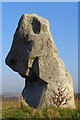
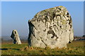
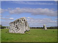
This badly damaged long mound apparently had a chamber at the eastern end.
"Neolithic unchambered long barrow (Grinsell's Avebury 68), excavated 1964-7, and radiocarbon dated to the 3rd millenium bc. Associated finds of pottery, flint, human and animal bone. Grooves scored across the old land surface beneath the barrow have been interpreted as ploughmarks. The barrow, which is in arable land, survives only as an amorphous ground swelling. It is visible as cropmarks on air photographs." - Pastscape monument no. 215484.
You may be viewing yesterday's version of this page. To see the most up to date information please register for a free account.
")
Do not use the above information on other web sites or publications without permission of the contributor.
coldrum has found this location on Google Street View:
Nearby Images from Geograph Britain and Ireland:
![SU0869 : A circular walk on the Downs from Avebury [3] by Michael Dibb](https://s2.geograph.org.uk/geophotos/06/47/06/6470670_0e335e58_120x120.jpg)
©2020(licence)
©2008(licence)
©2008(licence)
©2011(licence)
![SU0869 : A circular walk on the Downs from Avebury [2] by Michael Dibb](https://s1.geograph.org.uk/geophotos/06/47/06/6470669_b1452b3a_120x120.jpg)
©2020(licence)
The above images may not be of the site on this page, they are loaded from Geograph.
Please Submit an Image of this site or go out and take one for us!
Click here to see more info for this site
Nearby sites
Key: Red: member's photo, Blue: 3rd party photo, Yellow: other image, Green: no photo - please go there and take one, Grey: site destroyed
Download sites to:
KML (Google Earth)
GPX (GPS waypoints)
CSV (Garmin/Navman)
CSV (Excel)
To unlock full downloads you need to sign up as a Contributory Member. Otherwise downloads are limited to 50 sites.
Turn off the page maps and other distractions
Nearby sites listing. In the following links * = Image available
117m WNW 285° Longstone Cove* Standing Stones (SU0888769301)
326m WSW 247° Longstones Barrow* Long Barrow (SU08706914)
502m W 263° South of Penning Barn* Round Barrow(s) (SU08506921)
658m W 271° North of The Grange Round Barrow(s) (SU08346928)
1.1km ENE 62° Alexander Keiller Museum* Museum (SU100698)
1.2km NE 54° St. James's Church (Avebury) Ancient Cross (SU0997669968)
1.2km SE 126° Silbury Hill* Artificial Mound (SU10016853)
1.4km ENE 61° Avebury* Stone Circle (SU10266996)
1.5km ENE 59° Avebury - The Cove* Standing Stones (SU10257002)
1.5km WSW 238° Beckhampton Bowl Barrow Round Barrow(s) (SU07726847)
1.6km WSW 250° Fox Covert Barrows* Barrow Cemetery (SU07536873)
1.6km E 83° West Kennet Avenue polisher* Polissoir (SU10576947)
1.6km SE 137° Swallowhead Spring* Holy Well or Sacred Spring (SU101681)
1.7km E 90° West Kennet Avenue* Multiple Stone Rows / Avenue (SU10696928)
1.7km WSW 248° Fox Covert Bowl Barrows Barrow Cemetery (SU07416861)
1.7km W 268° Knoll Down Barrows* Barrow Cemetery (SU0725369219)
1.9km SE 138° West Kennet Barrow Round Barrow(s) (SU10246788)
1.9km ESE 120° Silbaby* Misc. Earthwork (SU1062668354)
1.9km SW 215° Bishops Cannings 88 Bell Barrow* Round Barrow(s) (SU0793367741)
1.9km SW 217° Bishops Cannings 89 Bowl Barrow* Round Barrow(s) (SU0785467757)
2.0km E 89° Falkner's Circle* Stone Circle (SU10986931)
2.1km N 349° Picket Barrow* Round Barrow(s) (SU086713)
2.1km WNW 291° Cherhill Cursus Cursus (SU07057000)
2.1km N 350° Windmill Hill Barrows* Round Barrow(s) (SU08637135)
2.1km S 171° Beckhampton Penning barrows Barrow Cemetery (SU09356717)
View more nearby sites and additional images


 We would like to know more about this location. Please feel free to add a brief description and any relevant information in your own language.
 Wir möchten mehr über diese Stätte erfahren. Bitte zögern Sie nicht, eine kurze Beschreibung und relevante Informationen in Deutsch hinzuzufügen.
 Nous aimerions en savoir encore un peu sur les lieux. S'il vous plaît n'hesitez pas à ajouter une courte description et tous les renseignements pertinents dans votre propre langue.
 Quisieramos informarnos un poco más de las lugares. No dude en añadir una breve descripción y otros datos relevantes en su propio idioma.