<< Our Photo Pages >> Redman's Hill Barrow - Round Barrow(s) in England in Dorset
Submitted by Gedv1 on Friday, 18 March 2011 Page Views: 5142
Neolithic and Bronze AgeSite Name: Redman's Hill BarrowCountry: England
NOTE: This site is 0.9 km away from the location you searched for.
County: Dorset Type: Round Barrow(s)
Nearest Town: Verwood Nearest Village: Three Legged Cross
Map Ref: SU073075
Latitude: 50.866960N Longitude: 1.897635W
Condition:
| 5 | Perfect |
| 4 | Almost Perfect |
| 3 | Reasonable but with some damage |
| 2 | Ruined but still recognisable as an ancient site |
| 1 | Pretty much destroyed, possibly visible as crop marks |
| 0 | No data. |
| -1 | Completely destroyed |
| 5 | Superb |
| 4 | Good |
| 3 | Ordinary |
| 2 | Not Good |
| 1 | Awful |
| 0 | No data. |
| 5 | Can be driven to, probably with disabled access |
| 4 | Short walk on a footpath |
| 3 | Requiring a bit more of a walk |
| 2 | A long walk |
| 1 | In the middle of nowhere, a nightmare to find |
| 0 | No data. |
| 5 | co-ordinates taken by GPS or official recorded co-ordinates |
| 4 | co-ordinates scaled from a detailed map |
| 3 | co-ordinates scaled from a bad map |
| 2 | co-ordinates of the nearest village |
| 1 | co-ordinates of the nearest town |
| 0 | no data |
Internal Links:
External Links:
")
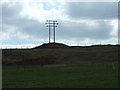
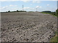
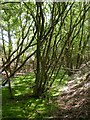
This high barrow on a north eastern spur on the northern side of the hill away from the dyke and ditch complex, is greatly degraded due to farming, and no doubt its exposure. It is on private land only to be seen by climbing a bank to field fence line.
The mound to extreme right is modern to hold telegraph poles.
You may be viewing yesterday's version of this page. To see the most up to date information please register for a free account.
")
Do not use the above information on other web sites or publications without permission of the contributor.
Nearby Images from Geograph Britain and Ireland:
©2010(licence)
©2009(licence)
©2009(licence)
©2009(licence)
©2009(licence)
The above images may not be of the site on this page, they are loaded from Geograph.
Please Submit an Image of this site or go out and take one for us!
Click here to see more info for this site
Nearby sites
Key: Red: member's photo, Blue: 3rd party photo, Yellow: other image, Green: no photo - please go there and take one, Grey: site destroyed
Download sites to:
KML (Google Earth)
GPX (GPS waypoints)
CSV (Garmin/Navman)
CSV (Excel)
To unlock full downloads you need to sign up as a Contributory Member. Otherwise downloads are limited to 50 sites.
Turn off the page maps and other distractions
Nearby sites listing. In the following links * = Image available
360m SSE 146° Horton Common Earthworks* Misc. Earthwork (SU075072)
1.0km W 264° David's Cross* Round Barrow(s) (SU063074)
1.6km NNW 330° Woodlands Common Barrow* Round Barrow(s) (SU065089)
2.2km W 265° Roman Barrow, Knob's Crook* Round Barrow(s) (SU051073)
2.8km NE 39° Stephen's Castle Tumulus* Round Barrow(s) (SU091097)
3.2km SW 215° Holt Heath* Round Barrow(s) (SU055049)
3.3km NE 39° Verwood Stone* Standing Stone (Menhir) (SU09371005)
3.4km NE 36° Boveridge Heath* Round Barrow(s) (SU093103)
3.6km E 84° Ebblake Barrow* Round Barrow(s) (SU109079)
3.9km ESE 102° Ashley Heath North* Round Barrow(s) (SU111067)
4.4km NE 55° Plumley Wood* Barrow Cemetery (SU109100)
4.4km WSW 246° Colebarrow* Hillfort (SU033057)
4.7km SE 140° Lions Hill Enclosure* Misc. Earthwork (SU103039)
5.1km NE 52° Sleep Valley Barrow* Round Barrow(s) (SU113106)
5.1km NW 305° Knowle Hill Farm long barrow* Long Barrow (SU0306210415)
5.4km WNW 296° Knowlton Great Circle* Henge (SU024099)
5.5km WNW 300° Knowlton Great Barrow* Round Barrow(s) (SU02541027)
5.6km WNW 300° Knowlton Rings* Henge (SU02381028)
5.7km NW 326° Wimborne St Giles* Round Barrow(s) (SU041122)
5.7km ESE 105° Bakers Hanging* Round Barrow(s) (SU128060)
5.8km ESE 108° Ashley Heath* Round Barrow(s) (SU128057)
6.2km ESE 110° Watchmoor Wood* Round Barrow(s) (SU131054)
6.4km NNW 345° The Ancient Technology Centre* Museum (SU05671374)
7.1km SSE 162° Trickett's Cross Barrow* Round Barrow(s) (SU095007)
7.5km W 259° High Lea Farm* Barrow Cemetery (ST999061)
View more nearby sites and additional images


 We would like to know more about this location. Please feel free to add a brief description and any relevant information in your own language.
 Wir möchten mehr über diese Stätte erfahren. Bitte zögern Sie nicht, eine kurze Beschreibung und relevante Informationen in Deutsch hinzuzufügen.
 Nous aimerions en savoir encore un peu sur les lieux. S'il vous plaît n'hesitez pas à ajouter une courte description et tous les renseignements pertinents dans votre propre langue.
 Quisieramos informarnos un poco más de las lugares. No dude en añadir una breve descripción y otros datos relevantes en su propio idioma.