


<< Our Photo Pages >> Old Bath Road Tumulus - Round Barrow(s) in England in Wiltshire
Submitted by vieveforward on Friday, 24 March 2017 Page Views: 1910
Neolithic and Bronze AgeSite Name: Old Bath Road TumulusCountry: England County: Wiltshire Type: Round Barrow(s)
Nearest Village: Yatesbury
Map Ref: SU06746963
Latitude: 51.425639N Longitude: 1.90445W
Condition:
| 5 | Perfect |
| 4 | Almost Perfect |
| 3 | Reasonable but with some damage |
| 2 | Ruined but still recognisable as an ancient site |
| 1 | Pretty much destroyed, possibly visible as crop marks |
| 0 | No data. |
| -1 | Completely destroyed |
| 5 | Superb |
| 4 | Good |
| 3 | Ordinary |
| 2 | Not Good |
| 1 | Awful |
| 0 | No data. |
| 5 | Can be driven to, probably with disabled access |
| 4 | Short walk on a footpath |
| 3 | Requiring a bit more of a walk |
| 2 | A long walk |
| 1 | In the middle of nowhere, a nightmare to find |
| 0 | No data. |
| 5 | co-ordinates taken by GPS or official recorded co-ordinates |
| 4 | co-ordinates scaled from a detailed map |
| 3 | co-ordinates scaled from a bad map |
| 2 | co-ordinates of the nearest village |
| 1 | co-ordinates of the nearest town |
| 0 | no data |
Internal Links:
External Links:
I have visited· I would like to visit
TheCaptain visited on 4th Oct 1998 Visit lots of ancient sites on a long off road cycle tour from Avebury to Windmill Hill, along the Wansdyke and back up Kennet Avenue
")
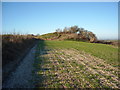
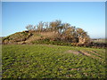
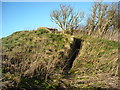
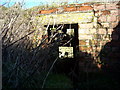
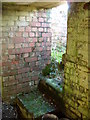
During WW2, the barrow was damaged in order to insert an anti-aircraft post, one of five light anti-aircraft gun emplacements that made up part of the airfield defences of the Radio School at RAF Yatesbury. The extant gun emplacement consists of a twin gun‐pit, blast shelter and zig‐zag blast corridor.
You may be viewing yesterday's version of this page. To see the most up to date information please register for a free account.
Do not use the above information on other web sites or publications without permission of the contributor.
Nearby Images from Geograph Britain and Ireland:
©2014(licence)
©2014(licence)
©2014(licence)
©2014(licence)
©2014(licence)
The above images may not be of the site on this page, they are loaded from Geograph.
Please Submit an Image of this site or go out and take one for us!
Click here to see more info for this site
Nearby sites
Key: Red: member's photo, Blue: 3rd party photo, Yellow: other image, Green: no photo - please go there and take one, Grey: site destroyed
Download sites to:
KML (Google Earth)
GPX (GPS waypoints)
CSV (Garmin/Navman)
CSV (Excel)
To unlock full downloads you need to sign up as a Contributory Member. Otherwise downloads are limited to 50 sites.
Turn off the page maps and other distractions
Nearby sites listing. In the following links * = Image available
482m NE 40° Cherhill Cursus Cursus (SU07057000)
656m SE 129° Knoll Down Barrows* Barrow Cemetery (SU0725369219)
1.2km W 280° Whitehorse Plantation NE Barrow* Round Barrow(s) (SU0556669845)
1.2km SE 139° Fox Covert Barrows* Barrow Cemetery (SU07536873)
1.2km SSE 147° Fox Covert Bowl Barrows Barrow Cemetery (SU07416861)
1.4km SSE 167° Henge and Four Bronze Age Barrows South West of Fox Covert* Barrow Cemetery (SU07066830)
1.5km SSW 214° Beckhampton (Avebury 6) Round Barrow(s) (SU05936841)
1.5km SE 140° Beckhampton Bowl Barrow Round Barrow(s) (SU07726847)
1.6km S 181° Bishops Cannings 26 Bell Barrow* Round Barrow(s) (SU0671268009)
1.6km ESE 102° North of The Grange Round Barrow(s) (SU08346928)
1.7km W 270° Oldbury Earthwork Misc. Earthwork (SU05036964)
1.8km W 268° Cherhill White Horse* Hill Figure or Geoglyph (SU04986958)
1.8km ESE 104° South of Penning Barn* Round Barrow(s) (SU08506921)
1.8km SSE 163° Beckhampton Firs Barrows* Barrow Cemetery (SU07276787)
1.8km WSW 250° Oldbury Barrow Round Barrow(s) (SU050690)
1.9km W 260° Oldbury Castle* Hillfort (SU049693)
1.9km SSW 209° North Down Tumulus Round Barrow(s) (SU05836797)
1.9km S 179° Beckhampton Firs Long Barrow* Long Barrow (SU0678267707)
2.0km S 180° Beckhampton Buildings Barrows Round Barrow(s) (SU06736766)
2.0km S 191° Down Barn Tumuli* Round Barrow(s) (SU06366766)
2.0km ESE 104° Longstones Barrow* Long Barrow (SU08706914)
2.1km W 261° Oldbury Hill Chambered Tomb (SU047693)
2.1km S 177° Beckhampton Firs Tumulus* Round Barrow(s) (SU06846754)
2.1km SW 222° North Down Barrows Round Barrow(s) (SU05316804)
2.2km E 99° Longstone Cove* Standing Stones (SU0888769301)
View more nearby sites and additional images


 We would like to know more about this location. Please feel free to add a brief description and any relevant information in your own language.
 Wir möchten mehr über diese Stätte erfahren. Bitte zögern Sie nicht, eine kurze Beschreibung und relevante Informationen in Deutsch hinzuzufügen.
 Nous aimerions en savoir encore un peu sur les lieux. S'il vous plaît n'hesitez pas à ajouter une courte description et tous les renseignements pertinents dans votre propre langue.
 Quisieramos informarnos un poco más de las lugares. No dude en añadir una breve descripción y otros datos relevantes en su propio idioma.