<< Our Photo Pages >> Stoup High Edge - Cairn in England in Derbyshire
Submitted by postman on Wednesday, 15 January 2014 Page Views: 2222
Neolithic and Bronze AgeSite Name: Stoup High EdgeCountry: England County: Derbyshire Type: Cairn
Nearest Town: Buxton Nearest Village: Hollinsclough
Map Ref: SK061684
Latitude: 53.212627N Longitude: 1.910116W
Condition:
| 5 | Perfect |
| 4 | Almost Perfect |
| 3 | Reasonable but with some damage |
| 2 | Ruined but still recognisable as an ancient site |
| 1 | Pretty much destroyed, possibly visible as crop marks |
| 0 | No data. |
| -1 | Completely destroyed |
| 5 | Superb |
| 4 | Good |
| 3 | Ordinary |
| 2 | Not Good |
| 1 | Awful |
| 0 | No data. |
| 5 | Can be driven to, probably with disabled access |
| 4 | Short walk on a footpath |
| 3 | Requiring a bit more of a walk |
| 2 | A long walk |
| 1 | In the middle of nowhere, a nightmare to find |
| 0 | No data. |
| 5 | co-ordinates taken by GPS or official recorded co-ordinates |
| 4 | co-ordinates scaled from a detailed map |
| 3 | co-ordinates scaled from a bad map |
| 2 | co-ordinates of the nearest village |
| 1 | co-ordinates of the nearest town |
| 0 | no data |
Internal Links:
External Links:
")
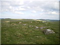
A fairly low but easily identified barrow with some stone poking through the grass.
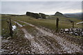
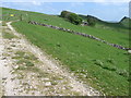
A short walk from the road with loads of parking opportunities.
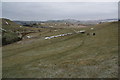
Another cairn from the upper Dove valley, and another cairn with a tremendous view, over to the south is Hollins hill and its cairn, east is Chrome hill, caves and more cairns, north is high edge and it's cairn (which ive yet to find) and west is where the peak district fades off to the Cheshire plains and home.
You may be viewing yesterday's version of this page. To see the most up to date information please register for a free account.
")
Do not use the above information on other web sites or publications without permission of the contributor.
Nearby Images from Geograph Britain and Ireland:
©2010(licence)
©2013(licence)
©2009(licence)

©2018(licence)
©2013(licence)
The above images may not be of the site on this page, they are loaded from Geograph.
Please Submit an Image of this site or go out and take one for us!
Click here to see more info for this site
Nearby sites
Key: Red: member's photo, Blue: 3rd party photo, Yellow: other image, Green: no photo - please go there and take one, Grey: site destroyed
Download sites to:
KML (Google Earth)
GPX (GPS waypoints)
CSV (Garmin/Navman)
CSV (Excel)
To unlock full downloads you need to sign up as a Contributory Member. Otherwise downloads are limited to 50 sites.
Turn off the page maps and other distractions
Nearby sites listing. In the following links * = Image available
510m SSW 191° Hollins Hill* Cairn (SK060679)
1.2km NNW 329° The Frith* Round Barrow(s) (SK055694)
1.2km W 269° Brand End standing stones* Standing Stones (SK0488868373)
1.5km E 88° Upper Edge* Cairn (SK07656845)
1.7km ESE 118° Dowel Cave* Cave or Rock Shelter (SK076676)
1.7km ESE 121° Etches cave* Cave or Rock Shelter (SK076675)
2.1km S 175° Coatestown Barrow Round Barrow(s) (SK063663)
2.1km E 101° Harley Grange Tumulus* Round Barrow(s) (SK082680)
2.3km ESE 119° Hatch-a-way* Cairn (SK081673)
2.7km NNW 327° Anthony Hill bowl barrow* Round Barrow(s) (SK04657066)
2.9km NNE 13° Fox Low Round Barrow(s) (SK06737122)
3.1km ESE 123° Hitter hill* Cairn (SK087667)
3.4km NNW 348° Grin Low* Cairn (SK05397173)
3.6km E 93° Hind Low* Ancient Village or Settlement (SK097682)
3.8km NNE 12° Staden Low* Misc. Earthwork (SK06917212)
4.0km WNW 300° Dane Head* Marker Stone (SK02657036)
4.0km NE 39° Gospel Hillocks* Long Barrow (SK086715)
4.2km NNW 345° Poole’s Cavern* Cave or Rock Shelter (SK050725)
4.3km WSW 251° Flash Chambered Tomb (SK0267)
4.4km ESE 120° Fox Hole Cave* Cave or Rock Shelter (SK099662)
4.4km ESE 121° Fox Hole Cave (Earl Sterndale)* Cave or Rock Shelter (SK099661)
4.6km NE 51° Hob Thirst's Cave* Cave or Rock Shelter (SK097713)
4.8km E 81° Nether Low* Round Barrow(s) (SK10896917)
4.9km N 358° Buxton Museum & Art Gallery* Museum (SK059733)
5.1km N 356° St Ann's Well (Buxton)* Holy Well or Sacred Spring (SK057735)
View more nearby sites and additional images


 We would like to know more about this location. Please feel free to add a brief description and any relevant information in your own language.
 Wir möchten mehr über diese Stätte erfahren. Bitte zögern Sie nicht, eine kurze Beschreibung und relevante Informationen in Deutsch hinzuzufügen.
 Nous aimerions en savoir encore un peu sur les lieux. S'il vous plaît n'hesitez pas à ajouter une courte description et tous les renseignements pertinents dans votre propre langue.
 Quisieramos informarnos un poco más de las lugares. No dude en añadir una breve descripción y otros datos relevantes en su propio idioma.