


<< Our Photo Pages >> Low Moor (W Yorks) - Round Barrow(s) in England in Yorkshire (West)
Submitted by rich32 on Monday, 22 August 2005 Page Views: 4664
Neolithic and Bronze AgeSite Name: Low Moor (W Yorks)Country: England County: Yorkshire (West) Type: Round Barrow(s)
Nearest Town: Ilkley Nearest Village: Addingham
Map Ref: SE0581750001
Latitude: 53.946083N Longitude: 1.912862W
Condition:
| 5 | Perfect |
| 4 | Almost Perfect |
| 3 | Reasonable but with some damage |
| 2 | Ruined but still recognisable as an ancient site |
| 1 | Pretty much destroyed, possibly visible as crop marks |
| 0 | No data. |
| -1 | Completely destroyed |
| 5 | Superb |
| 4 | Good |
| 3 | Ordinary |
| 2 | Not Good |
| 1 | Awful |
| 0 | No data. |
| 5 | Can be driven to, probably with disabled access |
| 4 | Short walk on a footpath |
| 3 | Requiring a bit more of a walk |
| 2 | A long walk |
| 1 | In the middle of nowhere, a nightmare to find |
| 0 | No data. |
| 5 | co-ordinates taken by GPS or official recorded co-ordinates |
| 4 | co-ordinates scaled from a detailed map |
| 3 | co-ordinates scaled from a bad map |
| 2 | co-ordinates of the nearest village |
| 1 | co-ordinates of the nearest town |
| 0 | no data |
Internal Links:
External Links:
 (PID:16338)")
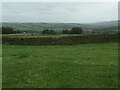
A rather sorry flattened round barrow, some 270 meters SE of the settlement at Round Dykes. Believe it, or not, this is actually scheduled, but it doesn’t seem to have afforded it any protection.
You may be viewing yesterday's version of this page. To see the most up to date information please register for a free account.
Do not use the above information on other web sites or publications without permission of the contributor.
Nearby Images from Geograph Britain and Ireland:
©2023(licence)

©2025(licence)
©2023(licence)
©2023(licence)

©2011(licence)
The above images may not be of the site on this page, they are loaded from Geograph.
Please Submit an Image of this site or go out and take one for us!
Click here to see more info for this site
Nearby sites
Key: Red: member's photo, Blue: 3rd party photo, Yellow: other image, Green: no photo - please go there and take one, Grey: site destroyed
Download sites to:
KML (Google Earth)
GPX (GPS waypoints)
CSV (Garmin/Navman)
CSV (Excel)
To unlock full downloads you need to sign up as a Contributory Member. Otherwise downloads are limited to 50 sites.
Turn off the page maps and other distractions
Nearby sites listing. In the following links * = Image available
321m WNW 292° Round Dykes* Ancient Village or Settlement (SE0551850121)
722m W 278° Counter Hill (Addingham) Misc. Earthwork (SE051501)
952m WSW 238° High Marchup (Silsden) Cairn (SE0501249489)
1.2km W 268° Counter Hill (31) Rock Art (SE0463049950)
2.7km E 96° Wulfhere's Cross* Ancient Cross (SE085497)
2.7km E 97° St Peter (Addingham)* Ancient Cross (SE0851049671)
3.2km S 191° Haw 01* Rock Art (SE0520646856)
3.4km SE 143° Addingham Crag 01.* Rock Art (SE0787247265)
3.4km SE 143° Addingham Crag 01a* Rock Art (SE0790547265)
3.5km E 99° Castleberg (Nesfield) Promontory Fort / Cliff Castle (SE09254946)
3.6km SE 143° Noon Stone* Natural Stone / Erratic / Other Natural Feature (SE0804847106)
3.7km SE 137° Hardwick Holes 01* Rock Art (SE0830747310)
3.7km SSE 154° Doubler Stones Allotment 02* Rock Art (SE0745246655)
3.7km SSE 156° Doubler Stones Allotment 01* Rock Art (SE0735346584)
3.8km SSE 158° Doubler Stones* Rock Art (SE0723046523)
3.9km SSE 152° Doubler Stones Allotment 04* Rock Art (SE0765546610)
3.9km S 181° High Brunthwaite (32)* Rock Art (SE0576746143)
3.9km SE 138° Rock Art above Hardwick, Ilkley* Rock Art (SE0839947108)
3.9km S 176° Brunthwaite Crag 01* Rock Art (SE0609946106)
3.9km SE 133° Hardwick House 01* Rock Art (SE0871847337)
3.9km SE 137° Piper's Crag Stone* Rock Art (SE08494710)
3.9km SE 137° Piper's Crag 02* Rock Art (SE0849447103)
4.0km SSE 153° Doubler Stones Allotment 03* Rock Art (SE0765046480)
4.1km SE 136° Piper's Crag 03a* Rock Art (SE0867547067)
4.1km SE 136° Piper's Crag 03.* Rock Art (SE0867347062)
View more nearby sites and additional images


 We would like to know more about this location. Please feel free to add a brief description and any relevant information in your own language.
 Wir möchten mehr über diese Stätte erfahren. Bitte zögern Sie nicht, eine kurze Beschreibung und relevante Informationen in Deutsch hinzuzufügen.
 Nous aimerions en savoir encore un peu sur les lieux. S'il vous plaît n'hesitez pas à ajouter une courte description et tous les renseignements pertinents dans votre propre langue.
 Quisieramos informarnos un poco más de las lugares. No dude en añadir una breve descripción y otros datos relevantes en su propio idioma.