<< Our Photo Pages >> Maiden Castle (N Yorks) - Ancient Village or Settlement in England in Yorkshire (North)
Submitted by NeilD on Friday, 09 September 2005 Page Views: 14731
Multi-periodSite Name: Maiden Castle (N Yorks)Country: England
NOTE: This site is 4.084 km away from the location you searched for.
County: Yorkshire (North) Type: Ancient Village or Settlement
Nearest Town: Richmond Nearest Village: Grinton
Map Ref: SE02189808
Latitude: 54.378216N Longitude: 1.967944W
Condition:
| 5 | Perfect |
| 4 | Almost Perfect |
| 3 | Reasonable but with some damage |
| 2 | Ruined but still recognisable as an ancient site |
| 1 | Pretty much destroyed, possibly visible as crop marks |
| 0 | No data. |
| -1 | Completely destroyed |
| 5 | Superb |
| 4 | Good |
| 3 | Ordinary |
| 2 | Not Good |
| 1 | Awful |
| 0 | No data. |
| 5 | Can be driven to, probably with disabled access |
| 4 | Short walk on a footpath |
| 3 | Requiring a bit more of a walk |
| 2 | A long walk |
| 1 | In the middle of nowhere, a nightmare to find |
| 0 | No data. |
| 5 | co-ordinates taken by GPS or official recorded co-ordinates |
| 4 | co-ordinates scaled from a detailed map |
| 3 | co-ordinates scaled from a bad map |
| 2 | co-ordinates of the nearest village |
| 1 | co-ordinates of the nearest town |
| 0 | no data |
Internal Links:
External Links:
I have visited· I would like to visit
SumDoood would like to visit
drolaf visited on 2nd Jul 2024 - their rating: Cond: 3 Amb: 4 Access: 3 a large site the size only realised on visiting. ditches about 2m in quite good condition. on a flat site on the hillside. orientated with entrance to east on west east running hillside and valley.
Anne T visited on 30th Jul 2014 - their rating: Cond: 4 Amb: 4 Access: 3 We ran out of time to see this site on 11th July, when we visited Thorborough Henges and West Agra (we got thoroughly distracted by the tremendous rock art at the latter), so took advantage of a trip down to Nottingham to detour via North Yorkshire and Swaledale to visit Maiden Castle.
Signs of the recent Tour de France were everywhere in this area (lots of yellow bunting and yellow bicycles, and spray-painted signs of encouragement to the riders on the roads). We stopped off in picturesque Reeth for lunch, then headed off southwards through the village of Grinton, turning west down a small narrow road with views of the river Swale to the north. This single track road runs for about 2km past ‘Bleak House’ and Harkerside Place. There are a number of footpaths and bridleways which run past Maiden Castle, but we picked the westernmost one, just past the fort, where there is a small parking area, sufficient for 4 or 5 cars.
From the car park, there is clearly marked path which runs (quite steeply) up past the western edge of the fort. As we were putting on our walking boots, two walkers were coming down and commented that the fort was ‘very well preserved; well worth seeing’.
I don’t like steep slopes or drops, but the path was relatively easy, and I needed a helping hand in only one or two rocky parts.
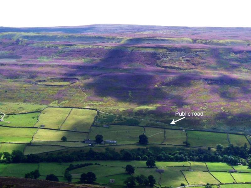
The fort was virtually invisible from the path, and is strangely situated part-way up the hillside. About 200 metres up the slope, the wsestern ditches of the fort suddenly come into view, then a few more paces open up a vista across the whole of the fort area. Turning to look back down the path, there are stunning views across the Swale valley and to the villages of Healaugh and Reeth across the valley.
There is a clear ditch and bank surrounding the fort; from the footpath to the west of the fort, it’s relatively easy to negotiate the ditch and bank easily (husband like a mountain goat, me picking my way gingerly), and ended up in a quiet, gentle spot, out of the wind and spotting rain. The brush underfoot wasn’t like other sites I’ve visited – the interior of the fort had what appeared to be low growing box plants with ferns, and we used sheep tracks to navigate from one point to the next within the fort area to avoid prickled ankles. At the southern end of the fort, where the slope drops steeply into the valley, there are quite a few tumbled stones, as if the fort had an outer wall at some point.
Before we visited, I had come across, and downloaded, the Durham University Archaeological Services report on Maiden Castle and West Hagg (geophysical surveys, report 2631, May 2011), which is available on the web when typing in ‘Maiden Castle Yorkshire’ on my web browser, so were able to largely identify the features they found within the fort, which was a real help in understanding what we were looking at.
Where their report had indicated a probable roundhouse, we found a circular area with very different vegetation, with low lying stones popping up through the grass to indicate where the foundation walls had been.
The walled approaches on the eastern side of the fort were impressive, giving the fort a ‘banjo’ shape. There is also a cairn/round barrow immediately adjacent to the northern end of the northern wall approach road to the fort.
Whilst exploring the fort, we saw other walkers pass by on the footpaths above and below, but very few people actually came into the fort, which was surprising. Definitely worth a visit.
Average ratings for this site from all visit loggers: Condition: 3.5 Ambience: 4 Access: 3

This monument has been described as a 'defended settlement' rather than a hillfort. It stands on the north-facing slope of Harker Hill. The earthworks here are fairly substantial measuring 108m east-west and 88m north-south. Hut circles and walls have also been found on the site.
You may be viewing yesterday's version of this page. To see the most up to date information please register for a free account.


Do not use the above information on other web sites or publications without permission of the contributor.
Click here to see more info for this site
Nearby sites
Key: Red: member's photo, Blue: 3rd party photo, Yellow: other image, Green: no photo - please go there and take one, Grey: site destroyed
Download sites to:
KML (Google Earth)
GPX (GPS waypoints)
CSV (Garmin/Navman)
CSV (Excel)
To unlock full downloads you need to sign up as a Contributory Member. Otherwise downloads are limited to 50 sites.
Turn off the page maps and other distractions
Nearby sites listing. In the following links * = Image available
170m ENE 69° Maiden Castle Barrow (Yorkshire North) Round Barrow(s) (SE02349814)
1.4km ESE 110° Harkerside Moor circle* Stone Circle (SE035976)
5.0km ENE 61° Whitton Burn(Rock Art) Rock Art (NZ066005)
5.9km ENE 65° Forty Acres 03 (Stelling) Rock Art (NZ07580058)
8.5km S 190° St Matthew's Well (Carperby)* Holy Well or Sacred Spring (SE0065689756)
8.5km S 191° Carperby Cross* Ancient Cross (SE0063189729)
8.6km SSW 202° Carperby Stone Circle* Stone Circle (SD99009013)
9.5km NNE 25° Frankinshaw* Cairn (NZ06170672)
9.8km NNE 18° Barningham Moor 60* Rock Art (NZ0520607422)
9.9km NNE 17° How Tallon Stone Circle* Stone Circle (NZ05150755)
10.0km NNE 21° How Tallon Cairn* Cairn (NZ05730740)
10.0km NNE 21° Barningham Moor 61 Rock Art (NZ0573907410)
10.0km NNE 18° Barningham Moor 59* Rock Art (NZ0522007624)
10.1km NNE 18° Barningham Moor 58* Rock Art (NZ0523207672)
10.1km NNE 18° Barningham Moor 89 Rock Art (NZ0534107709)
10.1km NNE 19° Barningham Moor 81 Rock Art (NZ0544307698)
10.2km NNE 19° Barningham Moor 77 Rock Art (NZ0547407695)
10.2km NNE 17° Barningham Moor 57* Rock Art (NZ0512907806)
10.2km NNE 19° Barningham Moor 118 Rock Art (NZ0549207690)
10.2km NNE 19° Barningham Moor 95 Rock Art (NZ0551607685)
10.2km NNE 19° Barningham Moor 80 Rock Art (NZ0545107708)
10.2km NNE 19° Barningham Moor 122 Rock Art (NZ0548507697)
10.2km NNE 19° Barningham Moor 78 Rock Art (NZ0547507704)
10.2km NNE 19° Barningham Moor 76 Rock Art (NZ0548507701)
10.2km NNE 19° Barningham Moor 74 Rock Art (NZ0552607687)
View more nearby sites and additional images


 We would like to know more about this location. Please feel free to add a brief description and any relevant information in your own language.
 Wir möchten mehr über diese Stätte erfahren. Bitte zögern Sie nicht, eine kurze Beschreibung und relevante Informationen in Deutsch hinzuzufügen.
 Nous aimerions en savoir encore un peu sur les lieux. S'il vous plaît n'hesitez pas à ajouter une courte description et tous les renseignements pertinents dans votre propre langue.
 Quisieramos informarnos un poco más de las lugares. No dude en añadir una breve descripción y otros datos relevantes en su propio idioma.