

<< Our Photo Pages >> Hasleden Barrow - Round Barrow(s) in England in Gloucestershire
Submitted by 4clydesdale7 on Friday, 12 August 2011 Page Views: 3684
Neolithic and Bronze AgeSite Name: Hasleden Barrow Alternative Name: Inlands Plantation BarrowCountry: England County: Gloucestershire Type: Round Barrow(s)
Nearest Town: Tetbury Nearest Village: Rodmarton
Map Ref: ST92949760
Latitude: 51.677121N Longitude: 2.103502W
Condition:
| 5 | Perfect |
| 4 | Almost Perfect |
| 3 | Reasonable but with some damage |
| 2 | Ruined but still recognisable as an ancient site |
| 1 | Pretty much destroyed, possibly visible as crop marks |
| 0 | No data. |
| -1 | Completely destroyed |
| 5 | Superb |
| 4 | Good |
| 3 | Ordinary |
| 2 | Not Good |
| 1 | Awful |
| 0 | No data. |
| 5 | Can be driven to, probably with disabled access |
| 4 | Short walk on a footpath |
| 3 | Requiring a bit more of a walk |
| 2 | A long walk |
| 1 | In the middle of nowhere, a nightmare to find |
| 0 | No data. |
| 5 | co-ordinates taken by GPS or official recorded co-ordinates |
| 4 | co-ordinates scaled from a detailed map |
| 3 | co-ordinates scaled from a bad map |
| 2 | co-ordinates of the nearest village |
| 1 | co-ordinates of the nearest town |
| 0 | no data |
Internal Links:
External Links:
I have visited· I would like to visit
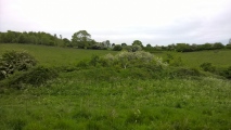
4clydesdale7 visited on 12th Aug 2011 - their rating: Cond: 2 Amb: 3 Access: 4 Those badgers have been working hard on their set - the Barrow is riddled with tunnels
")
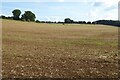
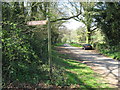
This Bronze Age Round Barrow never seems to be mentioned in its own right, because it is so near to the famous Windmill Tump and is less imposing it seems always to be the 'afterthought'. First excavated (before its illustrious neighbour) by Lysons in 1779, it is now in a seriously damaged condition having been the subject of a squat by badgers for countless years. It's diameter of 22m (curtailed to 15m by a drystone wall and a road to its S) is more impressive than its height of 1.5m. Although Lysons called it Inlands, it was given the Hasleden name by Rudder just a few years later, but then the nearest farm (to the N) is called Hazleton Manor Farm. You have to get into the thin sling of woodland or even into the field just to the north to get a fair appreciation of its size.
You may be viewing yesterday's version of this page. To see the most up to date information please register for a free account.
")
Do not use the above information on other web sites or publications without permission of the contributor.
Nearby Images from Geograph Britain and Ireland:
©2023(licence)
©2007(licence)
©2012(licence)
©2023(licence)
©2014(licence)
The above images may not be of the site on this page, they are loaded from Geograph.
Please Submit an Image of this site or go out and take one for us!
Click here to see more info for this site
Nearby sites
Key: Red: member's photo, Blue: 3rd party photo, Yellow: other image, Green: no photo - please go there and take one, Grey: site destroyed
Download sites to:
KML (Google Earth)
GPX (GPS waypoints)
CSV (Garmin/Navman)
CSV (Excel)
To unlock full downloads you need to sign up as a Contributory Member. Otherwise downloads are limited to 50 sites.
Turn off the page maps and other distractions
Nearby sites listing. In the following links * = Image available
424m SE 133° Windmill Tump* Long Barrow (ST93259731)
2.5km E 95° Haresdown Barrow* Round Barrow(s) (ST95489737)
2.8km SW 228° Warren Tump (Gloucestershire)* Round Barrow(s) (ST90889577)
3.4km W 274° Barrow Tumps* Long Barrow (ST89519783)
3.7km NW 312° Devil's Churchyard Stones* Stone Circle (SO9017000060)
4.1km W 281° Norn's Tump* Chambered Tomb (ST88949839)
4.3km SW 222° Tetbury Bowl Barrow* Round Barrow(s) (ST90039441)
4.6km SW 217° Worswell* Holy Well or Sacred Spring (ST90149395)
4.9km WNW 286° The Tingle Stone* Long Barrow (ST88239899)
5.0km WNW 295° Gatcombe Lodge* Long Barrow (ST88399972)
5.1km WNW 302° Crackstone Long Barrow* Long Barrow (SO88650030)
5.1km W 279° Avening burial chambers* Burial Chamber or Dolmen (ST87899837)
5.1km NNE 26° Cassey Well* Holy Well or Sacred Spring (SO952022)
5.1km WNW 297° Long Stone (Minchinhampton)* Standing Stones (ST8835099920)
5.3km NW 314° Hyde Tumulus 2* Round Barrow(s) (SO89070130)
5.3km SW 223° Magdalen Mead Well* Holy Well or Sacred Spring (ST89269371)
5.5km NW 315° Hyde Tumulus 1* Round Barrow(s) (SO89060149)
5.6km ENE 67° Trewsbury Camp* Hillfort (ST98109980)
5.7km NNW 343° Ashmead Well* Holy Well or Sacred Spring (SO91270301)
5.8km ENE 76° King Athelstans Mounting Stone* Marker Stone (ST98549899)
6.0km WNW 295° Bubblewell* Standing Stone (Menhir) (SO875001)
6.0km SW 220° Magdalen's spring* Holy Well or Sacred Spring (ST890930)
6.1km WSW 255° Chavenage Sleight Round Barrows* Round Barrow(s) (ST87089601)
6.1km E 82° Lyd Well (Kemble) Holy Well or Sacred Spring (ST98969847)
6.2km WNW 300° The Bulwarks - East 1 and 2 - Minchinhampton* Misc. Earthwork (SO87620072)
View more nearby sites and additional images


 We would like to know more about this location. Please feel free to add a brief description and any relevant information in your own language.
 Wir möchten mehr über diese Stätte erfahren. Bitte zögern Sie nicht, eine kurze Beschreibung und relevante Informationen in Deutsch hinzuzufügen.
 Nous aimerions en savoir encore un peu sur les lieux. S'il vous plaît n'hesitez pas à ajouter une courte description et tous les renseignements pertinents dans votre propre langue.
 Quisieramos informarnos un poco más de las lugares. No dude en añadir una breve descripción y otros datos relevantes en su propio idioma.