

<< Our Photo Pages >> Friarsfield - Stone Circle in Scotland in Aberdeenshire
Submitted by cosmic on Thursday, 25 March 2004 Page Views: 8057
Neolithic and Bronze AgeSite Name: Friarsfield Alternative Name: CultsCountry: Scotland County: Aberdeenshire Type: Stone Circle
Nearest Town: Aberdeen Nearest Village: Cults
Map Ref: NJ894035 Landranger Map Number: 38
Latitude: 57.122309N Longitude: 2.176696W
Condition:
| 5 | Perfect |
| 4 | Almost Perfect |
| 3 | Reasonable but with some damage |
| 2 | Ruined but still recognisable as an ancient site |
| 1 | Pretty much destroyed, possibly visible as crop marks |
| 0 | No data. |
| -1 | Completely destroyed |
| 5 | Superb |
| 4 | Good |
| 3 | Ordinary |
| 2 | Not Good |
| 1 | Awful |
| 0 | No data. |
| 5 | Can be driven to, probably with disabled access |
| 4 | Short walk on a footpath |
| 3 | Requiring a bit more of a walk |
| 2 | A long walk |
| 1 | In the middle of nowhere, a nightmare to find |
| 0 | No data. |
| 5 | co-ordinates taken by GPS or official recorded co-ordinates |
| 4 | co-ordinates scaled from a detailed map |
| 3 | co-ordinates scaled from a bad map |
| 2 | co-ordinates of the nearest village |
| 1 | co-ordinates of the nearest town |
| 0 | no data |
Internal Links:
External Links:
I have visited· I would like to visit
pawel visited on 19th Jan 2020 - their rating: Cond: 2 Amb: 2
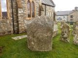
golux visited on 26th Oct 2014 - their rating: Cond: -1 Amb: 3 This site was reported destroyed in the Name Book of 1865. The stones lying on the site today are not likely to have any connection with the circle.
hamilton have visited here
Average ratings for this site from all visit loggers: Condition: 0.5 Ambience: 2.5
")
Friarsfield Road stone circle is still there. In the 1970s the Council (who own the land) did some landscaping and so the stones that can be seen at the site may be part of the original circle but they are not in their original positions.
You may be viewing yesterday's version of this page. To see the most up to date information please register for a free account.
")
")
")
Do not use the above information on other web sites or publications without permission of the contributor.
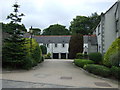
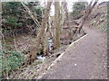
Nearby Images from Geograph Britain and Ireland:
©2005(licence)
©2005(licence)
©2009(licence)
©2014(licence)
©2010(licence)
The above images may not be of the site on this page, they are loaded from Geograph.
Please Submit an Image of this site or go out and take one for us!
Click here to see more info for this site
Nearby sites
Key: Red: member's photo, Blue: 3rd party photo, Yellow: other image, Green: no photo - please go there and take one, Grey: site destroyed
Download sites to:
KML (Google Earth)
GPX (GPS waypoints)
CSV (Garmin/Navman)
CSV (Excel)
To unlock full downloads you need to sign up as a Contributory Member. Otherwise downloads are limited to 50 sites.
Turn off the page maps and other distractions
Nearby sites listing. In the following links * = Image available
1.3km WSW 236° Bieldside* Cairn (NJ88340280)
2.4km ESE 119° Dunnicaer 1* Class I Pictish Symbol Stone (NJ91500232)
2.8km ESE 114° Tollohill* Ring Cairn (NJ91950235)
3.6km WNW 287° Blacktop* Rock Art (NJ85900455)
4.0km WSW 254° Binghill* Stone Circle (NJ85520237)
5.0km ENE 60° The Langstane* Standing Stone (Menhir) (NJ93770597)
5.5km NW 309° West Hatton* Chambered Cairn (NJ851070)
5.5km NNE 30° Lang Stane (Aberdeen)* Standing Stone (Menhir) (NJ922083)
5.6km E 91° Tullos Hut Circles* Ancient Village or Settlement (NJ950034)
5.6km ENE 60° Marischal Museum* Museum (NJ943063)
5.7km ENE 58° Tillytarmont 1* Class I Pictish Symbol Stone (NJ94280651)
5.8km E 94° Cat Cairn* Cairn (NJ952031)
6.0km SSE 163° Craighead Badentoy* Stone Circle (NO91189772)
6.1km SSE 168° Cairnwell* Stone Circle (NO90649750)
6.4km E 88° Baron's Cairn* Cairn (NJ958037)
6.5km S 181° Auchlee Cairn* Ring Cairn (NO893970)
6.5km E 85° Tullos Cairn* Cairn (NJ959041)
6.5km NE 44° King's Museum* Museum (NJ9391608216)
6.5km SSW 196° Craigentath Ancient Village or Settlement (NO876972)
6.6km S 183° Auchlee Circle* Stone Circle (NO890969)
6.9km E 88° Crab's Cairn* Cairn (NJ963037)
7.1km SSW 199° East Crossley Ancient Village or Settlement (NO871968)
7.2km S 174° Auchquhorthies* Stone Circle (NO90199634)
7.5km S 172° Old Bourtreebush* Stone Circle (NO9036096083)
7.6km SW 218° Standingstones* Standing Stones (NO847975)
View more nearby sites and additional images


 We would like to know more about this location. Please feel free to add a brief description and any relevant information in your own language.
 Wir möchten mehr über diese Stätte erfahren. Bitte zögern Sie nicht, eine kurze Beschreibung und relevante Informationen in Deutsch hinzuzufügen.
 Nous aimerions en savoir encore un peu sur les lieux. S'il vous plaît n'hesitez pas à ajouter une courte description et tous les renseignements pertinents dans votre propre langue.
 Quisieramos informarnos un poco más de las lugares. No dude en añadir una breve descripción y otros datos relevantes en su propio idioma.