<< Our Photo Pages >> Comb Scar - Ancient Village or Settlement in England in Yorkshire (North)
Submitted by rich32 on Thursday, 30 June 2005 Page Views: 7814
Multi-periodSite Name: Comb ScarCountry: England County: Yorkshire (North) Type: Ancient Village or Settlement
Nearest Town: Skipton Nearest Village: Malham
Map Ref: SD89366485
Latitude: 54.079459N Longitude: 2.164118W
Condition:
| 5 | Perfect |
| 4 | Almost Perfect |
| 3 | Reasonable but with some damage |
| 2 | Ruined but still recognisable as an ancient site |
| 1 | Pretty much destroyed, possibly visible as crop marks |
| 0 | No data. |
| -1 | Completely destroyed |
| 5 | Superb |
| 4 | Good |
| 3 | Ordinary |
| 2 | Not Good |
| 1 | Awful |
| 0 | No data. |
| 5 | Can be driven to, probably with disabled access |
| 4 | Short walk on a footpath |
| 3 | Requiring a bit more of a walk |
| 2 | A long walk |
| 1 | In the middle of nowhere, a nightmare to find |
| 0 | No data. |
| 5 | co-ordinates taken by GPS or official recorded co-ordinates |
| 4 | co-ordinates scaled from a detailed map |
| 3 | co-ordinates scaled from a bad map |
| 2 | co-ordinates of the nearest village |
| 1 | co-ordinates of the nearest town |
| 0 | no data |
Internal Links:
External Links:
I have visited· I would like to visit
SolarMegalith would like to visit
")
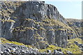
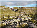
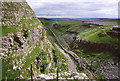
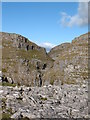
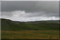
A single hut circle with a diameter of about 8 meters, tucked away in a gully between Comb Scar & Comb Hill. Protected from the elements by steep slopes to the north, east & west, with an open view looking south towards Malham. The entrance to dwelling faces east towards the steep slope.
This site was excavated in 1959 & is thought to date from the Bronze Age.
Well worth a visit for its location.
You may be viewing yesterday's version of this page. To see the most up to date information please register for a free account.
")
")
Do not use the above information on other web sites or publications without permission of the contributor.
Nearby Images from Geograph Britain and Ireland:
©2015(licence)
©2018(licence)
©2008(licence)
©2009(licence)
©2010(licence)
The above images may not be of the site on this page, they are loaded from Geograph.
Please Submit an Image of this site or go out and take one for us!
Click here to see more info for this site
Nearby sites
Key: Red: member's photo, Blue: 3rd party photo, Yellow: other image, Green: no photo - please go there and take one, Grey: site destroyed
Download sites to:
KML (Google Earth)
GPX (GPS waypoints)
CSV (Garmin/Navman)
CSV (Excel)
To unlock full downloads you need to sign up as a Contributory Member. Otherwise downloads are limited to 50 sites.
Turn off the page maps and other distractions
Nearby sites listing. In the following links * = Image available
228m S 190° Ing Scar* Ancient Village or Settlement (SD8931964626)
611m NE 44° Torlery Edge (Malham Moor) Ancient Village or Settlement (SD8978465292)
884m SW 222° Jorden Scar* Ancient Village or Settlement (SD88776419)
1.1km WSW 249° Ewe Moor* Ring Cairn (SD88326445)
1.4km ENE 68° Seaty Hill (Malham Moor) Cairn (SD9069265390)
1.8km SE 140° Malham settlements and field systems* Ancient Village or Settlement (SD905635)
3.3km WSW 242° Rye Loaf Hill (Settle) Cairn (SD8641963309)
5.0km NNE 21° Dewbottoms (Arncliffe) Ancient Village or Settlement (SD912695)
5.5km W 268° Attermire Scar (Settle)* Rock Art (SD83836464)
5.5km W 271° Victoria Cave* Cave or Rock Shelter (SD838650)
5.6km W 272° Albert Cave Cave or Rock Shelter (SD83796508)
5.6km E 86° Druid's Altar (Yorkshire)* Stone Circle (SD94946527)
5.8km E 86° Hammond Close Stone (Threshfield) Standing Stones (SD9516165209)
6.0km E 89° Hammond Close (Threshfield)* Ancient Village or Settlement (SD95386492)
6.0km E 82° Lantern Holes (Bordley)* Ancient Village or Settlement (SD95336566)
6.3km WNW 282° Samson's Toe (Langcliffe) Natural Stone / Erratic / Other Natural Feature (SD8317666229)
6.5km ENE 61° Kilnsey* Stone Circle (SD951680)
7.0km NE 55° Douky Bottom Ring (Arncliffe) Ancient Village or Settlement (SD9512668887)
7.1km NE 55° Dowkerbottom Cave* Cave or Rock Shelter (SD95176889)
7.1km E 92° Heights Cave* Cave or Rock Shelter (SD96446460)
7.2km NE 54° Douky Bottom Settlement (Arncliffe) Ancient Village or Settlement (SD9520369067)
7.3km NNE 32° Blue Scar (Arncliffe)* Ancient Village or Settlement (SD93237100)
7.6km S 171° Lower Colgarth Hill Tumulus* Round Barrow(s) (SD9048157360)
8.0km WSW 245° Cleatop Park* Stone Circle (SD82056145)
8.1km W 263° Bank Well* Holy Well or Sacred Spring (SD813639)
View more nearby sites and additional images


 We would like to know more about this location. Please feel free to add a brief description and any relevant information in your own language.
 Wir möchten mehr über diese Stätte erfahren. Bitte zögern Sie nicht, eine kurze Beschreibung und relevante Informationen in Deutsch hinzuzufügen.
 Nous aimerions en savoir encore un peu sur les lieux. S'il vous plaît n'hesitez pas à ajouter une courte description et tous les renseignements pertinents dans votre propre langue.
 Quisieramos informarnos un poco más de las lugares. No dude en añadir una breve descripción y otros datos relevantes en su propio idioma.