


<< Our Photo Pages >> Heights Cave - Cave or Rock Shelter in England in Yorkshire (North)
Submitted by cavegirl on Saturday, 04 September 2004 Page Views: 17384
Natural PlacesSite Name: Heights Cave Alternative Name: Calf Hole, Elland Cave, Skythorns CaveCountry: England County: Yorkshire (North) Type: Cave or Rock Shelter
Nearest Town: Grassington
Map Ref: SD96446460
Latitude: 54.077312N Longitude: 2.055902W
Condition:
| 5 | Perfect |
| 4 | Almost Perfect |
| 3 | Reasonable but with some damage |
| 2 | Ruined but still recognisable as an ancient site |
| 1 | Pretty much destroyed, possibly visible as crop marks |
| 0 | No data. |
| -1 | Completely destroyed |
| 5 | Superb |
| 4 | Good |
| 3 | Ordinary |
| 2 | Not Good |
| 1 | Awful |
| 0 | No data. |
| 5 | Can be driven to, probably with disabled access |
| 4 | Short walk on a footpath |
| 3 | Requiring a bit more of a walk |
| 2 | A long walk |
| 1 | In the middle of nowhere, a nightmare to find |
| 0 | No data. |
| 5 | co-ordinates taken by GPS or official recorded co-ordinates |
| 4 | co-ordinates scaled from a detailed map |
| 3 | co-ordinates scaled from a bad map |
| 2 | co-ordinates of the nearest village |
| 1 | co-ordinates of the nearest town |
| 0 | no data |
Internal Links:
External Links:
")
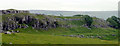
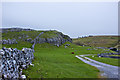
A nice cave with a prominent entrance split by a supporting rock column forming two arches.
It's got a great view across the valley and is in a lovely position. The cave was excavated in 1893 and a composite tool was found of a reindeer antler with a boar's tusk insert - this has been given a Mesolithic date. At a lower level were found bison, reindeer and bear bones. The wall was built by the excavators but sort of adds to the site. Please ask permission before visiting from Bell Bank (the farm lower down the lane)
You may be viewing yesterday's version of this page. To see the most up to date information please register for a free account.
Do not use the above information on other web sites or publications without permission of the contributor.
Nearby Images from Geograph Britain and Ireland:
©2020(licence)
©2019(licence)
©2008(licence)
©2019(licence)
©2010(licence)
The above images may not be of the site on this page, they are loaded from Geograph.
Please Submit an Image of this site or go out and take one for us!
Click here to see more info for this site
Nearby sites
Key: Red: member's photo, Blue: 3rd party photo, Yellow: other image, Green: no photo - please go there and take one, Grey: site destroyed
Download sites to:
KML (Google Earth)
GPX (GPS waypoints)
CSV (Garmin/Navman)
CSV (Excel)
To unlock full downloads you need to sign up as a Contributory Member. Otherwise downloads are limited to 50 sites.
Turn off the page maps and other distractions
Nearby sites listing. In the following links * = Image available
1.1km WNW 287° Hammond Close (Threshfield)* Ancient Village or Settlement (SD95386492)
1.3km NE 56° Chapel House Wood* Ancient Village or Settlement (SD9750165316)
1.4km WNW 295° Hammond Close Stone (Threshfield) Standing Stones (SD9516165209)
1.5km ENE 74° Brazen Gate* Round Cairn (SD9785964995)
1.5km NW 314° Lantern Holes (Bordley)* Ancient Village or Settlement (SD95336566)
1.6km WNW 294° Druid's Altar (Yorkshire)* Stone Circle (SD94946527)
1.8km E 100° Little Wood* Ancient Village or Settlement (SD98266429)
3.5km E 83° Cove Hole* Cave or Rock Shelter (SD99896499)
3.5km ENE 61° Lea Green cairn Cairn (SD995663)
3.7km NNW 338° Kilnsey* Stone Circle (SD951680)
3.9km E 80° Grassington Settlement Ancient Village or Settlement (SE0027765259)
4.2km ESE 110° The Linton Stones* Natural Stone / Erratic / Other Natural Feature (SE0042763177)
4.3km ESE 109° Linton Churchyard Cross* Ancient Cross (SE0053963220)
4.5km NNW 343° Dowkerbottom Cave* Cave or Rock Shelter (SD95176889)
4.5km NNW 343° Douky Bottom Ring (Arncliffe) Ancient Village or Settlement (SD9512668887)
4.6km NNW 345° Douky Bottom Settlement (Arncliffe) Ancient Village or Settlement (SD9520369067)
4.8km E 79° Yarnbury Settlement (Grassington) Ancient Village or Settlement (SE012655)
5.0km E 81° Yarnbury Henge* Henge (SE0140665415)
5.3km SE 125° Ebolton Cave* Cave or Rock Shelter (SE008616)
5.7km ENE 58° Green Hill Pasture Stone Circle* Stone Circle (SE013676)
5.8km W 278° Seaty Hill (Malham Moor) Cairn (SD9069265390)
5.8km S 173° St Peter's Church (Rylstone) Ancient Cross (SD972588)
6.0km W 259° Malham settlements and field systems* Ancient Village or Settlement (SD905635)
6.4km ENE 72° Grassington A* Stone Circle (SE025666)
6.4km ENE 71° Grassington B* Stone Circle (SE025667)
View more nearby sites and additional images


 We would like to know more about this location. Please feel free to add a brief description and any relevant information in your own language.
 Wir möchten mehr über diese Stätte erfahren. Bitte zögern Sie nicht, eine kurze Beschreibung und relevante Informationen in Deutsch hinzuzufügen.
 Nous aimerions en savoir encore un peu sur les lieux. S'il vous plaît n'hesitez pas à ajouter une courte description et tous les renseignements pertinents dans votre propre langue.
 Quisieramos informarnos un poco más de las lugares. No dude en añadir una breve descripción y otros datos relevantes en su propio idioma.