<< Our Photo Pages >> Fontmell Down - Misc. Earthwork in England in Dorset
Submitted by TimPrevett on Tuesday, 06 June 2006 Page Views: 7773
Multi-periodSite Name: Fontmell DownCountry: England County: Dorset Type: Misc. Earthwork
Nearest Town: Shaftesbury Nearest Village: Melbury Abbas
Map Ref: ST884183
Latitude: 50.964003N Longitude: 2.166554W
Condition:
| 5 | Perfect |
| 4 | Almost Perfect |
| 3 | Reasonable but with some damage |
| 2 | Ruined but still recognisable as an ancient site |
| 1 | Pretty much destroyed, possibly visible as crop marks |
| 0 | No data. |
| -1 | Completely destroyed |
| 5 | Superb |
| 4 | Good |
| 3 | Ordinary |
| 2 | Not Good |
| 1 | Awful |
| 0 | No data. |
| 5 | Can be driven to, probably with disabled access |
| 4 | Short walk on a footpath |
| 3 | Requiring a bit more of a walk |
| 2 | A long walk |
| 1 | In the middle of nowhere, a nightmare to find |
| 0 | No data. |
| 5 | co-ordinates taken by GPS or official recorded co-ordinates |
| 4 | co-ordinates scaled from a detailed map |
| 3 | co-ordinates scaled from a bad map |
| 2 | co-ordinates of the nearest village |
| 1 | co-ordinates of the nearest town |
| 0 | no data |
Internal Links:
External Links:
I have visited· I would like to visit
TimPrevett has visited here
")
A long cross dyke bisecting Fontmell Down, visible from Spread Eagle Hill road (used as an alternative Blandford - Shaftesbury route by many). A dedicated parking area, and public footpath give direct access to the centre of the dyke. Panoramic views to the west. One of 64+ cross dykes in Dorset.
You may be viewing yesterday's version of this page. To see the most up to date information please register for a free account.
")
Do not use the above information on other web sites or publications without permission of the contributor.
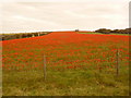
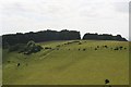
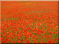
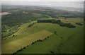
Nearby Images from Geograph Britain and Ireland:
©2009(licence)
©2017(licence)
©2009(licence)
©2017(licence)
©2009(licence)
The above images may not be of the site on this page, they are loaded from Geograph.
Please Submit an Image of this site or go out and take one for us!
Click here to see more info for this site
Nearby sites
Key: Red: member's photo, Blue: 3rd party photo, Yellow: other image, Green: no photo - please go there and take one, Grey: site destroyed
Download sites to:
KML (Google Earth)
GPX (GPS waypoints)
CSV (Garmin/Navman)
CSV (Excel)
To unlock full downloads you need to sign up as a Contributory Member. Otherwise downloads are limited to 50 sites.
Turn off the page maps and other distractions
Nearby sites listing. In the following links * = Image available
4.2km NNE 28° Chapel Well (Donhead St Mary) Holy Well or Sacred Spring (ST90372196)
5.3km ESE 120° Caesar's Camp (Dorset)* Hillfort (ST930156)
6.4km SW 221° Hambledon Farm Stone Circle* Modern Stone Circle etc (ST8420413467)
6.7km SW 217° Hambledon Hillfort Spur Enclosure Misc. Earthwork (ST84351290)
6.8km SSW 209° Eastern Cross Dyke Misc. Earthwork (ST85051242)
6.8km SW 215° Hambledon Hill hillfort* Hillfort (ST84511270)
6.8km N 4° Castle Rings* Hillfort (ST889251)
6.9km SW 214° Hambledon Hill long barrow Long Barrow (ST84511265)
7.1km SSW 210° Hambledon Hill enclosure* Causewayed Enclosure (ST848122)
7.1km SE 132° Chettle Long Barrow* Long Barrow (ST937135)
7.2km SSW 209° Hambledon Hill long barrow* Long Barrow (ST84891205)
7.2km SSW 210° Southern cross-dyke* Misc. Earthwork (ST84791202)
7.4km SSW 204° Stepleton Enclosure Causewayed Enclosure (ST8540311526)
7.6km ENE 63° Winklebury Camp (Wiltshire) Hillfort (ST952218)
8.2km SSW 200° Hod Hill* Hillfort (ST856106)
8.3km NE 45° White Sheet Hill Long Barrow (ST94242419)
8.5km SSE 157° Pimperne Long Barrow* Long Barrow (ST917105)
8.6km SE 129° Chettle House* Long Barrow (ST9506612803)
8.8km E 93° Scrubbity Barrows* Barrow Cemetery (ST97201789)
9.2km NE 51° Gallows Hill, Wiltshire Round Barrow(s) (ST95542411)
9.5km ESE 123° Thickthorn Farm Long Barrow (ST964131)
10.2km ESE 122° Ogden Down 3 Timber Circle (ST971129)
10.3km ENE 72° South Down Ox Drove Tumuli* Round Barrow(s) (ST982215)
10.3km SE 125° Gussage St Michael Cursus Cursus (ST969124)
10.4km SSE 163° Blandford Race Down Round Barrow(s) (ST91360836)
View more nearby sites and additional images


 We would like to know more about this location. Please feel free to add a brief description and any relevant information in your own language.
 Wir möchten mehr über diese Stätte erfahren. Bitte zögern Sie nicht, eine kurze Beschreibung und relevante Informationen in Deutsch hinzuzufügen.
 Nous aimerions en savoir encore un peu sur les lieux. S'il vous plaît n'hesitez pas à ajouter une courte description et tous les renseignements pertinents dans votre propre langue.
 Quisieramos informarnos un poco más de las lugares. No dude en añadir una breve descripción y otros datos relevantes en su propio idioma.