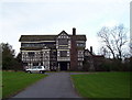
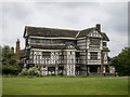
<< Our Photo Pages >> Little Moreton Hall - Round Barrow(s) in England in Cheshire
Submitted by PaulM on Sunday, 10 June 2007 Page Views: 11600
Neolithic and Bronze AgeSite Name: Little Moreton HallCountry: England
NOTE: This site is 2.6 km away from the location you searched for.
County: Cheshire Type: Round Barrow(s)
Nearest Town: Congleton Nearest Village: Astbury
Map Ref: SJ832589 Landranger Map Number: 118
Latitude: 53.126998N Longitude: 2.252518W
Condition:
| 5 | Perfect |
| 4 | Almost Perfect |
| 3 | Reasonable but with some damage |
| 2 | Ruined but still recognisable as an ancient site |
| 1 | Pretty much destroyed, possibly visible as crop marks |
| 0 | No data. |
| -1 | Completely destroyed |
| 5 | Superb |
| 4 | Good |
| 3 | Ordinary |
| 2 | Not Good |
| 1 | Awful |
| 0 | No data. |
| 5 | Can be driven to, probably with disabled access |
| 4 | Short walk on a footpath |
| 3 | Requiring a bit more of a walk |
| 2 | A long walk |
| 1 | In the middle of nowhere, a nightmare to find |
| 0 | No data. |
| 5 | co-ordinates taken by GPS or official recorded co-ordinates |
| 4 | co-ordinates scaled from a detailed map |
| 3 | co-ordinates scaled from a bad map |
| 2 | co-ordinates of the nearest village |
| 1 | co-ordinates of the nearest town |
| 0 | no data |
Internal Links:
External Links:
I have visited· I would like to visit
TimPrevett has visited here
")
One of two mounds located in the grounds of Little Moreton Hall in Cheshire. It is postulated that this mound is a barrow but could equally be a more recent landscaped mound. However Jodrell Hall nearby contains barrows that have been incorporated into the gardens as at Jodrell Hall in Cheshire.
Note: David Dimbleby's "How we built Britain" tonight visits Little Moreton Hall (among others), home to these two possible round barrows. BBC1 9.30 to 10.30pm BST.
You may be viewing yesterday's version of this page. To see the most up to date information please register for a free account.
")
")
Do not use the above information on other web sites or publications without permission of the contributor.
coldrum has found this location on Google Street View:
Nearby Images from Geograph Britain and Ireland:
©2005(licence)
©2013(licence)
©2015(licence)
©2015(licence)
©2013(licence)
The above images may not be of the site on this page, they are loaded from Geograph.
Please Submit an Image of this site or go out and take one for us!
Click here to see more info for this site
Nearby sites
Key: Red: member's photo, Blue: 3rd party photo, Yellow: other image, Green: no photo - please go there and take one, Grey: site destroyed
Download sites to:
KML (Google Earth)
GPX (GPS waypoints)
CSV (Garmin/Navman)
CSV (Excel)
To unlock full downloads you need to sign up as a Contributory Member. Otherwise downloads are limited to 50 sites.
Turn off the page maps and other distractions
Nearby sites listing. In the following links * = Image available
3.0km NNE 25° Astbury Churchyard* Round Barrow(s) (SJ845616)
3.0km NNE 30° St Marys (Astbury)* Ancient Cross (SJ847615)
3.3km SSW 198° All Saints (Church Lawton)* Artificial Mound (SJ82165573)
3.8km SW 217° Church Lawton Barrows* Barrow Cemetery (SJ809559)
4.0km SW 217° Church Lawton South* Stone Circle (SJ808557)
4.5km N 357° Loachbrook Farm* Long Barrow (SJ830634)
4.8km NE 34° Congleton Museum* Museum (SJ859629)
5.3km ESE 113° Red Cross* Ancient Cross (SJ881568)
6.0km NNW 339° Somerford Round Barrow Round Barrow(s) (SJ811645)
6.6km ENE 76° Shepherd's Cross* Standing Stone (Menhir) (SJ89626042)
7.4km ESE 117° Gawton's Well* Holy Well or Sacred Spring (SJ89825555)
7.5km ESE 118° Gawton's Stone* Modern Stone Circle etc (SJ898554)
7.6km WNW 285° Sandbach Crosses* Ancient Cross (SJ7587760825)
7.9km SSE 155° Tunstall Park* Natural Stone / Erratic / Other Natural Feature (SJ865517)
8.0km NNW 346° Swettenham Hall* Round Barrow(s) (SJ813667)
8.1km ENE 66° The Bridestones (Cheshire)* Chambered Tomb (SJ9058962190)
8.6km ENE 58° Bosley Cloud (2)* Standing Stone (Menhir) (SJ906634)
8.7km ENE 57° Bosley Cloud (1)* Standing Stone (Menhir) (SJ905636)
8.8km NNW 339° St Peter (Swettenham) Ancient Cross (SJ80086718)
10.7km ENE 73° Satan's Stone* Natural Stone / Erratic / Other Natural Feature (SJ93406206)
11.3km ENE 73° St Helen's Well (Rushton Spencer)* Holy Well or Sacred Spring (SJ94076222)
12.1km SSE 154° Hanley Stone Circle* Modern Stone Circle etc (SJ884480)
12.2km NNW 340° Jodrell Bank* Barrow Cemetery (SJ791704)
12.5km NNW 340° Axstone cross* Ancient Cross (SJ789706)
12.6km SSE 157° Potteries Museum & Art Gallery* Museum (SJ8815147308)
View more nearby sites and additional images


 We would like to know more about this location. Please feel free to add a brief description and any relevant information in your own language.
 Wir möchten mehr über diese Stätte erfahren. Bitte zögern Sie nicht, eine kurze Beschreibung und relevante Informationen in Deutsch hinzuzufügen.
 Nous aimerions en savoir encore un peu sur les lieux. S'il vous plaît n'hesitez pas à ajouter une courte description et tous les renseignements pertinents dans votre propre langue.
 Quisieramos informarnos un poco más de las lugares. No dude en añadir una breve descripción y otros datos relevantes en su propio idioma.