<< Text Pages >> Whitley Pike 1 - Rock Art in England in Northumberland
Submitted by Anne T on Sunday, 21 July 2002 Page Views: 3990
Rock ArtSite Name: Whitley Pike 1 Alternative Name: ERA-1421; Beckensall 695; North Sunday SightCountry: England County: Northumberland Type: Rock Art
Nearest Town: Otterburn Nearest Village: Highgreen Manor
Map Ref: NY8269791258 Landranger Map Number: 80
Latitude: 55.215253N Longitude: 2.273485W
Condition:
| 5 | Perfect |
| 4 | Almost Perfect |
| 3 | Reasonable but with some damage |
| 2 | Ruined but still recognisable as an ancient site |
| 1 | Pretty much destroyed, possibly visible as crop marks |
| 0 | No data. |
| -1 | Completely destroyed |
| 5 | Superb |
| 4 | Good |
| 3 | Ordinary |
| 2 | Not Good |
| 1 | Awful |
| 0 | No data. |
| 5 | Can be driven to, probably with disabled access |
| 4 | Short walk on a footpath |
| 3 | Requiring a bit more of a walk |
| 2 | A long walk |
| 1 | In the middle of nowhere, a nightmare to find |
| 0 | No data. |
| 5 | co-ordinates taken by GPS or official recorded co-ordinates |
| 4 | co-ordinates scaled from a detailed map |
| 3 | co-ordinates scaled from a bad map |
| 2 | co-ordinates of the nearest village |
| 1 | co-ordinates of the nearest town |
| 0 | no data |
Be the first person to rate this site - see the 'Contribute!' box in the right hand menu.
Internal Links:
External Links:
Rock Art in Northumberland
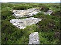
This rock art panel is recorded by NADRAP as being on a steeply sloping rock slab on a bank. The panel has a curved groove arising from its western edge where it forms a ridge and forms a rounded, but not circular feature. NADRAP says this is different from the other panels on the ridge which appear as shallow basins, and concludes this is possibly a natural erosion feature accentuated by water flowing down the rock surface. Beckensall had previously recorded this panel as having a single basin (taken from Charlton, 1983).
For a more detailed description and more information see England's Rock Art entry for ERA-1421 Whitley Pike 1, which includes NADRAP's notes, Beckensall's Archive Notes and description, photographs, a sketch of the rock and its motifs, plus photogrammetry and media from the Beckensall Archive.
The original Beckensall record can be found at Internet Archive: Beckensall 695 Whitley Pike 1, North Sunday Sight.
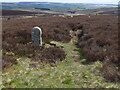
This rock art panel is located on Open Access land.
You may be viewing yesterday's version of this page. To see the most up to date information please register for a free account.
Do not use the above information on other web sites or publications without permission of the contributor.
Nearby Images from Geograph Britain and Ireland:
©2009(licence)
©2007(licence)
©2019(licence)
©2011(licence)
©2023(licence)
The above images may not be of the site on this page, they are loaded from Geograph.
Please Submit an Image of this site or go out and take one for us!
Click here to see more info for this site
Nearby sites
Key: Red: member's photo, Blue: 3rd party photo, Yellow: other image, Green: no photo - please go there and take one, Grey: site destroyed
Download sites to:
KML (Google Earth)
GPX (GPS waypoints)
CSV (Garmin/Navman)
CSV (Excel)
To unlock full downloads you need to sign up as a Contributory Member. Otherwise downloads are limited to 50 sites.
Turn off the page maps and other distractions
Nearby sites listing. In the following links * = Image available
61m E 99° Whitley Pike 2 Rock Art (NY8275791248)
62m E 101° Whitley Pike 3 Rock Art (NY8275891246)
83m ESE 109° Whitley Pike 4 Rock Art (NY8277691231)
101m ESE 114° Whitley Pike 5 Rock Art (NY8278991216)
1.1km NW 322° Padon Hill a Rock Art (NY8199692154)
1.1km NW 322° Padon Hill N01 Rock Art (NY8199292157)
1.4km NW 321° Padon Hill b Rock Art (NY8183292339)
4.6km NE 40° Brownrigg (Rochester)* Ancient Cross (NY8566894716)
5.8km WSW 249° Sidwood Iron Age Settlement* Ancient Village or Settlement (NY77288925)
6.6km NNE 26° Yatesfield Hill (Otterburn)* Standing Stone (Menhir) (NY8563297177)
6.6km ESE 107° St Cuthbert's Church (Corsenside)* Ancient Cross (NY8902089266)
6.9km N 2° Rochester (Otterburn)* Modern Stone Circle etc (NY8293998149)
6.9km S 180° Reenes Farm Rock Art (NY8266084340)
7.0km N 9° Bremenium Roman tumulus* Artificial Mound (NY8384098165)
7.1km ESE 120° Woodhouse (West Woodburn)* Cairn (NY8888187732)
7.1km NNE 27° Yatesfield (Otterburn)* Ancient Village or Settlement (NY85939763)
7.5km N 349° Burdhope (Rochester)* Ancient Village or Settlement (NY8128098584)
8.0km S 173° St Cuthbert's Well (Bellingham)* Holy Well or Sacred Spring (NY837833)
8.4km S 184° Crag Well (Bellingham)* Holy Well or Sacred Spring (NY8212282858)
8.6km ENE 58° Todlaw Pike Rock Art (NY900958)
8.6km SSE 153° Rede Settlement Ancient Village or Settlement (NY866836)
9.2km NNW 347° Bellshiel Law 2f Rock Art (NT8064400188)
9.3km N 353° Bellshiel Law 2e Rock Art (NT8158800501)
9.3km SE 127° Robin of Risingham (Woodburn)* Carving (NY90148564)
9.4km N 353° Bellshiel Law 2a Rock Art (NT8154200601)
View more nearby sites and additional images


 We would like to know more about this location. Please feel free to add a brief description and any relevant information in your own language.
 Wir möchten mehr über diese Stätte erfahren. Bitte zögern Sie nicht, eine kurze Beschreibung und relevante Informationen in Deutsch hinzuzufügen.
 Nous aimerions en savoir encore un peu sur les lieux. S'il vous plaît n'hesitez pas à ajouter une courte description et tous les renseignements pertinents dans votre propre langue.
 Quisieramos informarnos un poco más de las lugares. No dude en añadir una breve descripción y otros datos relevantes en su propio idioma.