<< Our Photo Pages >> Woodleaze Farm - Long Barrow in England in Gloucestershire
Submitted by TheCaptain on Monday, 15 November 2004 Page Views: 7289
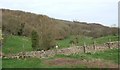
Neolithic and Bronze AgeSite Name: Woodleaze Farm Alternative Name: Kingscote ICountry: England County: Gloucestershire Type: Long Barrow
Nearest Town: Nailsworth Nearest Village: Kingscote
Map Ref: ST820976 Landranger Map Number: 162
Latitude: 51.676875N Longitude: 2.261718W
Condition:
| 5 | Perfect |
| 4 | Almost Perfect |
| 3 | Reasonable but with some damage |
| 2 | Ruined but still recognisable as an ancient site |
| 1 | Pretty much destroyed, possibly visible as crop marks |
| 0 | No data. |
| -1 | Completely destroyed |
| 5 | Superb |
| 4 | Good |
| 3 | Ordinary |
| 2 | Not Good |
| 1 | Awful |
| 0 | No data. |
| 5 | Can be driven to, probably with disabled access |
| 4 | Short walk on a footpath |
| 3 | Requiring a bit more of a walk |
| 2 | A long walk |
| 1 | In the middle of nowhere, a nightmare to find |
| 0 | No data. |
| 5 | co-ordinates taken by GPS or official recorded co-ordinates |
| 4 | co-ordinates scaled from a detailed map |
| 3 | co-ordinates scaled from a bad map |
| 2 | co-ordinates of the nearest village |
| 1 | co-ordinates of the nearest town |
| 0 | no data |
Internal Links:
External Links:
I have visited· I would like to visit
4clydesdale7 visited on 19th Apr 2013 - their rating: Cond: 2 Amb: 4 Access: 4 How on earth did the famed George Witts miss this one? - super views and loads of other interesting sites locally
TheCaptain have visited here
")
You may be viewing yesterday's version of this page. To see the most up to date information please register for a free account.
")
")
Do not use the above information on other web sites or publications without permission of the contributor.
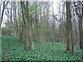
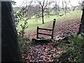
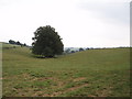
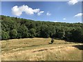
Nearby Images from Geograph Britain and Ireland:
©2009(licence)
©2023(licence)
©2006(licence)
©2018(licence)
©2007(licence)
The above images may not be of the site on this page, they are loaded from Geograph.
Please Submit an Image of this site or go out and take one for us!
Click here to see more info for this site
Nearby sites
Key: Red: member's photo, Blue: 3rd party photo, Yellow: other image, Green: no photo - please go there and take one, Grey: site destroyed
Download sites to:
KML (Google Earth)
GPX (GPS waypoints)
CSV (Garmin/Navman)
CSV (Excel)
To unlock full downloads you need to sign up as a Contributory Member. Otherwise downloads are limited to 50 sites.
Turn off the page maps and other distractions
Nearby sites listing. In the following links * = Image available
480m E 93° Woodleaze Bowl Barrow* Round Barrow(s) (ST82489757)
1.8km N 2° Lutheredge Earthworks* Misc. Earthwork (ST82089943)
2.8km SW 235° Symonds Hall Farm* Long Barrow (ST79719599)
3.0km SSW 195° Kingscote Standing Stones* Standing Stones (ST81189467)
3.4km WSW 247° Wotton Under Edge Cursus Cursus (ST789963)
3.8km WNW 290° Uley Bury* Hillfort (ST78459891)
3.9km NW 309° Hetty Pegler's Tump* Passage Grave (SO78960003)
3.9km ENE 77° Hazlewood Copse Camp* Hillfort (ST85829850)
4.0km E 91° Lechmore Round Barrow* Round Barrow(s) (ST860975)
4.0km E 87° Lechmore Tump* Long Barrow (ST86049783)
4.0km S 191° Brock Hill Round Barrow(s) (ST81219363)
4.1km NE 54° Beaudesert Park Standing Stone* Standing Stone (Menhir) (SO853000)
4.2km N 4° Bown Hill Long Barrow* Long Barrow (SO82290179)
4.2km W 261° Rowden Wood* Chambered Tomb (ST77819692)
4.2km ENE 75° Oldfield Wood* Chambered Tomb (ST861987)
4.2km N 3° Bown Hill Bowl Barrow* Round Barrow(s) (SO82240184)
4.5km NNW 348° Woodchester Beaker Barrow* Round Barrow(s) (SO81100198)
4.5km N 357° Kings Stanley Dyke* Misc. Earthwork (SO818021)
4.5km NNW 332° Buckholt Wood* Chambered Tomb (SO79860157)
4.5km NW 325° Nympsfield* Long Barrow (SO79400132)
4.6km SSE 155° Beverston Barrow 1* Round Barrow(s) (ST83949344)
4.6km NE 53° The Bulwarks (Gloucestershire)* Ancient Village or Settlement (SO857004)
4.7km NW 326° Soldier's Grave* Round Barrow(s) (SO79350150)
4.7km W 261° Folly Wood* Chambered Tomb (ST77339689)
4.8km NE 40° Amberley Cross Bank* Misc. Earthwork (SO85130124)
View more nearby sites and additional images


 We would like to know more about this location. Please feel free to add a brief description and any relevant information in your own language.
 Wir möchten mehr über diese Stätte erfahren. Bitte zögern Sie nicht, eine kurze Beschreibung und relevante Informationen in Deutsch hinzuzufügen.
 Nous aimerions en savoir encore un peu sur les lieux. S'il vous plaît n'hesitez pas à ajouter une courte description et tous les renseignements pertinents dans votre propre langue.
 Quisieramos informarnos un poco más de las lugares. No dude en añadir una breve descripción y otros datos relevantes en su propio idioma.