<< Our Photo Pages >> Kingscote Standing Stones - Standing Stones in England in Gloucestershire
Submitted by 4clydesdale7 on Thursday, 25 August 2011 Page Views: 5903
Neolithic and Bronze AgeSite Name: Kingscote Standing StonesCountry: England County: Gloucestershire Type: Standing Stones
Nearest Town: Nailsworth Nearest Village: Kingscote
Map Ref: ST81189467
Latitude: 51.650504N Longitude: 2.273419W
Condition:
| 5 | Perfect |
| 4 | Almost Perfect |
| 3 | Reasonable but with some damage |
| 2 | Ruined but still recognisable as an ancient site |
| 1 | Pretty much destroyed, possibly visible as crop marks |
| 0 | No data. |
| -1 | Completely destroyed |
| 5 | Superb |
| 4 | Good |
| 3 | Ordinary |
| 2 | Not Good |
| 1 | Awful |
| 0 | No data. |
| 5 | Can be driven to, probably with disabled access |
| 4 | Short walk on a footpath |
| 3 | Requiring a bit more of a walk |
| 2 | A long walk |
| 1 | In the middle of nowhere, a nightmare to find |
| 0 | No data. |
| 5 | co-ordinates taken by GPS or official recorded co-ordinates |
| 4 | co-ordinates scaled from a detailed map |
| 3 | co-ordinates scaled from a bad map |
| 2 | co-ordinates of the nearest village |
| 1 | co-ordinates of the nearest town |
| 0 | no data |
Internal Links:
External Links:
I have visited· I would like to visit
4clydesdale7 visited on 24th Aug 2011 - their rating: Cond: 2 Amb: 3 Access: 3 Difficult to find but the reward is twofold - an isolated standing stone and some sloes
")
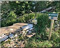
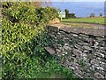
The same adheres today but it is much more difficult to find because it is being carefully cosseted by a very large bush of juicy sloes.
The wall is alongside (for most of the time) a public footpath between Bagpath and Newington Bagpath just N of Scrubbetts Farm. After the path veers NE the wall continues SE for about 200m and then itself turns NE but then it peters out and the field boundary becomes an hedge.
Just 3m before the end of the wall (on the N side) the sole remaining stone can be seen (below the sloe bush) jutting out. At this point the wall seems to have run along the top of a slightly higher piece of ground - what is more is that it is aligned NE/SW - so it just could be part of an old barrow.
oh! and by the way I shall be returning for the Sloes!
Pastscape website 209170
You may be viewing yesterday's version of this page. To see the most up to date information please register for a free account.
")
Do not use the above information on other web sites or publications without permission of the contributor.
Nearby Images from Geograph Britain and Ireland:
©2005(licence)
©2022(licence)
©2024(licence)
©2014(licence)
©2020(licence)
The above images may not be of the site on this page, they are loaded from Geograph.
Please Submit an Image of this site or go out and take one for us!
Click here to see more info for this site
Nearby sites
Key: Red: member's photo, Blue: 3rd party photo, Yellow: other image, Green: no photo - please go there and take one, Grey: site destroyed
Download sites to:
KML (Google Earth)
GPX (GPS waypoints)
CSV (Garmin/Navman)
CSV (Excel)
To unlock full downloads you need to sign up as a Contributory Member. Otherwise downloads are limited to 50 sites.
Turn off the page maps and other distractions
Nearby sites listing. In the following links * = Image available
1.0km S 178° Brock Hill Round Barrow(s) (ST81219363)
2.0km NW 312° Symonds Hall Farm* Long Barrow (ST79719599)
2.1km SSE 168° St. Mary's Well (Boxwell)* Holy Well or Sacred Spring (ST816926)
2.4km SSE 162° Boxwell Lodge* Chambered Tomb (ST819924)
2.8km NW 305° Wotton Under Edge Cursus Cursus (ST789963)
3.0km ESE 114° Beverston Barrow 1* Round Barrow(s) (ST83949344)
3.0km NNE 15° Woodleaze Farm* Long Barrow (ST820976)
3.2km NNE 24° Woodleaze Bowl Barrow* Round Barrow(s) (ST82489757)
3.4km SSE 167° Leighterton Long Barrow* Long Barrow (ST81929131)
3.9km WSW 248° Blackquarries Hill* Chambered Tomb (ST77529323)
4.0km WNW 304° Rowden Wood* Chambered Tomb (ST77819692)
4.3km SE 128° Bowldownwood Round Barrows* Round Barrow(s) (ST84569205)
4.4km WNW 300° Folly Wood* Chambered Tomb (ST77339689)
4.8km N 10° Lutheredge Earthworks* Misc. Earthwork (ST82089943)
5.0km NNW 327° Uley Bury* Hillfort (ST78459891)
5.1km SSE 168° Parkwood Farm* Round Barrow(s) (ST822897)
5.4km S 189° Nan Tow's Tump* Round Barrow(s) (ST80288932)
5.6km ENE 59° Lechmore Round Barrow* Round Barrow(s) (ST860975)
5.8km E 93° Beverston Barrow 2* Round Barrow(s) (ST86969433)
5.8km ENE 57° Lechmore Tump* Long Barrow (ST86049783)
5.8km NNW 337° Hetty Pegler's Tump* Passage Grave (SO78960003)
5.9km E 90° Beverston Barrow 4* Round Barrow(s) (ST87069460)
6.0km NE 50° Hazlewood Copse Camp* Hillfort (ST85829850)
6.0km ENE 77° Chavenage Sleight Round Barrows* Round Barrow(s) (ST87089601)
6.1km NW 323° Cam Long Down Hillfort* Hillfort (ST7753399507)
View more nearby sites and additional images


 We would like to know more about this location. Please feel free to add a brief description and any relevant information in your own language.
 Wir möchten mehr über diese Stätte erfahren. Bitte zögern Sie nicht, eine kurze Beschreibung und relevante Informationen in Deutsch hinzuzufügen.
 Nous aimerions en savoir encore un peu sur les lieux. S'il vous plaît n'hesitez pas à ajouter une courte description et tous les renseignements pertinents dans votre propre langue.
 Quisieramos informarnos un poco más de las lugares. No dude en añadir una breve descripción y otros datos relevantes en su propio idioma.