<< Our Photo Pages >> Wardstone Barrow - Round Barrow(s) in England in Dorset
Submitted by JimChampion on Monday, 31 December 2007 Page Views: 8081
Neolithic and Bronze AgeSite Name: Wardstone BarrowCountry: England County: Dorset Type: Round Barrow(s)
Nearest Town: Wareham Nearest Village: Chaldon Herring
Map Ref: SY79338133
Latitude: 50.631297N Longitude: 2.293615W
Condition:
| 5 | Perfect |
| 4 | Almost Perfect |
| 3 | Reasonable but with some damage |
| 2 | Ruined but still recognisable as an ancient site |
| 1 | Pretty much destroyed, possibly visible as crop marks |
| 0 | No data. |
| -1 | Completely destroyed |
| 5 | Superb |
| 4 | Good |
| 3 | Ordinary |
| 2 | Not Good |
| 1 | Awful |
| 0 | No data. |
| 5 | Can be driven to, probably with disabled access |
| 4 | Short walk on a footpath |
| 3 | Requiring a bit more of a walk |
| 2 | A long walk |
| 1 | In the middle of nowhere, a nightmare to find |
| 0 | No data. |
| 5 | co-ordinates taken by GPS or official recorded co-ordinates |
| 4 | co-ordinates scaled from a detailed map |
| 3 | co-ordinates scaled from a bad map |
| 2 | co-ordinates of the nearest village |
| 1 | co-ordinates of the nearest town |
| 0 | no data |
Internal Links:
External Links:
I have visited· I would like to visit
Ogham visited on 9th Aug 2008 - their rating: Cond: 3 Amb: 4 Access: 2 It is in a magnificent location on the chalk downs above the coastal path.
JimChampion have visited here
")
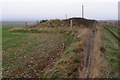
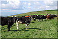
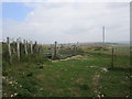
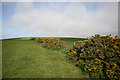
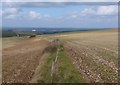
This barrow is on the chalk ridge just inland from the coast, between the White Nothe headland and West Lulworth. It was originally one of a pair, but the eastern barrow has been levelled by farming activity. The mound is 15 metres in diameter, up to 2 metres high, and the surrounding ditch is mostly infilled. The mound is now overgrown with gorse and brambles.
The name of this barrow probably comes from the Anglo-Saxon "weard-stān", meaning stone where watch was kept. The barrow is located in a very prominent position on the coastal ridge with good visibility all around, over land and sea. There is no record of a megalith at the site - only of an excavation in 1867 that uncovered a cinerary urn.
Access The barrow is alongside a permissive footpath, about 300 metres south of Chideock Farm.
You may be viewing yesterday's version of this page. To see the most up to date information please register for a free account.
Do not use the above information on other web sites or publications without permission of the contributor.
Nearby Images from Geograph Britain and Ireland:
©2007(licence)
©2008(licence)
©2014(licence)
©2007(licence)
©2009(licence)
The above images may not be of the site on this page, they are loaded from Geograph.
Please Submit an Image of this site or go out and take one for us!
Click here to see more info for this site
Nearby sites
Key: Red: member's photo, Blue: 3rd party photo, Yellow: other image, Green: no photo - please go there and take one, Grey: site destroyed
Download sites to:
KML (Google Earth)
GPX (GPS waypoints)
CSV (Garmin/Navman)
CSV (Excel)
To unlock full downloads you need to sign up as a Contributory Member. Otherwise downloads are limited to 50 sites.
Turn off the page maps and other distractions
Nearby sites listing. In the following links * = Image available
1.0km W 263° Chaldon Down* Barrow Cemetery (SY783812)
2.5km ESE 115° Hambury Tout Barrows* Barrow Cemetery (SY81588029)
2.9km N 353° Five Marys* Barrow Cemetery (SY790842)
3.3km NNW 332° Lord's Barrow* Round Barrow(s) (SY778842)
3.9km ESE 105° Bindon Hill* Hillfort (SY831803)
4.6km WNW 285° Southdown (Dorset)* Barrow Cemetery (SY749825)
4.8km ESE 103° Bindon Hill Barrows* Barrow Cemetery (SY84078026)
5.1km NNE 14° Blacknoll Hill* Barrow Cemetery (SY80638630)
5.3km WNW 295° Poxwell Cairn* Cairn (SY74518357)
7.0km E 89° East Lulworth* Barrow Cemetery (SY863814)
7.0km NE 51° Woodman's Cross* Barrow Cemetery (SY84838573)
7.1km E 96° Flower's Barrow* Hillfort (SY86388056)
7.2km E 86° Water Barrows Round Barrow(s) (SY865818)
7.3km E 87° Ferny Barrows* Round Barrow(s) (SY866817)
7.3km ENE 65° Coombe Beacon Barrow Cemetery (SY860844)
7.4km E 90° Boat Knoll* Round Barrow(s) (SY867813)
7.7km E 92° Lulworth stone circle Stone Circle (SY870810)
9.1km ENE 72° Povington Heath Barrows Barrow Cemetery (SY880841)
9.2km WNW 292° Northdown (Dorset)* Barrow Cemetery (SY708848)
9.3km NW 308° Little Mayne* Stone Circle (SY720870)
9.9km WNW 293° Broadmayne Bank Barrow* Long Barrow (SY702853)
10.1km WNW 284° Chalbury* Hillfort (SY695838)
10.3km NW 312° Whitcombe* Standing Stone (Menhir) (SY717883)
10.4km WNW 295° Whitcombe 1* Long Barrow (SY699858)
10.9km WNW 288° Bincombe Barrows* Barrow Cemetery (SY689847)
View more nearby sites and additional images


 We would like to know more about this location. Please feel free to add a brief description and any relevant information in your own language.
 Wir möchten mehr über diese Stätte erfahren. Bitte zögern Sie nicht, eine kurze Beschreibung und relevante Informationen in Deutsch hinzuzufügen.
 Nous aimerions en savoir encore un peu sur les lieux. S'il vous plaît n'hesitez pas à ajouter une courte description et tous les renseignements pertinents dans votre propre langue.
 Quisieramos informarnos un poco más de las lugares. No dude en añadir una breve descripción y otros datos relevantes en su propio idioma.